Supercharge Your Innovation With Domain-Expert AI Agents!

Unmanned global path planning and re-planning method in cross-country environment

A global path planning, unmanned technology, applied in two-dimensional position/channel control, vehicle position/route/altitude control, non-electric variable control and other directions, can solve unfavorable data analysis and visualization, complex process, high precision Problems such as complex map storage methods

Active Publication Date: 2021-07-16
HEFEI INSTITUTES OF PHYSICAL SCIENCE - CHINESE ACAD OF SCI
View PDF8 Cites 9 Cited by
  • Summary
  • Abstract
  • Description
  • Claims
  • Application Information

AI Technical Summary

Problems solved by technology

[0003] The disadvantage of the existing technology is that in the current high-precision map drawing scheme, a large number of steps such as laser point cloud conversion, splicing, labeling and indexing are required, and the process is very complicated and requires professional technicians
This makes high-precision maps expensive, highly specialized, and inefficient in production
At the same time, the storage method of the existing high-precision map is complicated, and it also relies on a large amount of manual work, and the analysis method is complicated, which is not conducive to the data analysis and visualization of the path planning of the autonomous vehicle.
At the same time, there are few automatic driving path planning methods for off-road environments. Compared with the traditional global path planning methods in urban structured environments, off-road environment maps cannot provide lane-level positioning and navigation information, which has great disadvantages. Deterministic, path planning is more difficult

Method used


Image

  • Unmanned global path planning and re-planning method in cross-country environment
  • Unmanned global path planning and re-planning method in cross-country environment
  • Unmanned global path planning and re-planning method in cross-country environment

Examples


Embodiment Construction

[0056] The following will clearly and completely describe the technical solutions in the embodiments of the present invention with reference to the accompanying drawings in the embodiments of the present invention. Obviously, the described embodiments are only some, not all, embodiments of the present invention. Based on the embodiments of the present invention, all other embodiments obtained by persons of ordinary skill in the art without making creative efforts belong to the protection scope of the present invention.

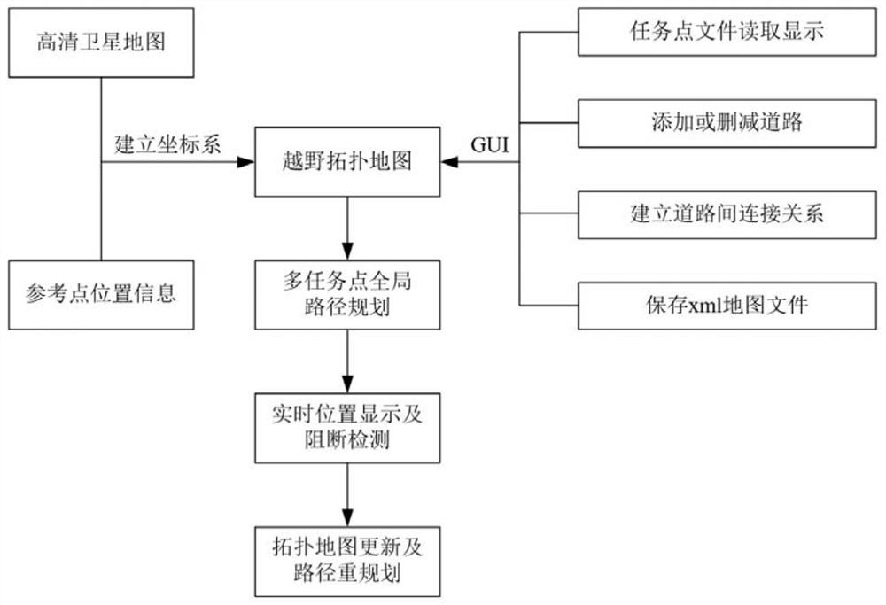
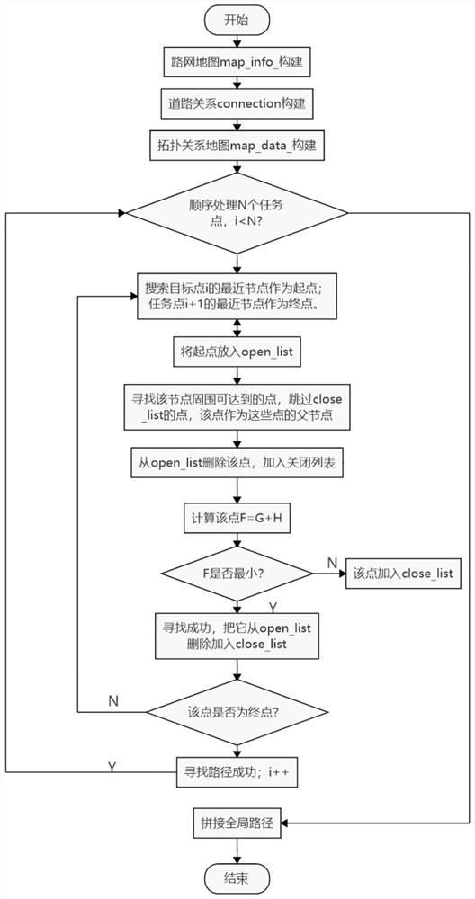
[0057] Please refer to figure 1 and figure 2 , in an embodiment of the present invention, an unmanned driving global path planning and re-planning method in an off-road environment, the specific steps include:

[0058] S1. Obtain satellite map information and reference point location information, and establish a coordinate system. The specific steps include:

[0059] Obtain high-definition satellite map information and reference point location information f...


PUM


Abstract

The invention discloses an unmanned global path planning and re-planning method in a cross-country environment. The method specifically comprises steps of obtaining the high-definition satellite map information and the position information of a plurality of reference points, and building a local coordinate system; acquiring a topological map, reading task point information, and editing and correcting the task point information to generate a map file; acquiring the global position information of each point of the topological map according to the coordinate system transformation; and realizing multi-task point path planning based on an Astar algorithm, determining the real-time position of the vehicle in the driving process, and carrying out road blocking detection and re-planning. In the driving process of the automatic driving vehicle, the vehicle position and track information can be displayed in real time, the blocking signal of the sensing module is received, if blocking is triggered after the blocking signal is filtered, a road topological structure is reset, a global path is re-planned according to the current position information, and a global path planning task of the remaining task points is completed.

Description

technical field [0001] The invention relates to the technical field of automatic driving path planning, in particular to an unmanned driving global path planning and re-planning method in an off-road environment. Background technique [0002] The global path planning of autonomous vehicles in off-road environments has important application significance. In the current global path planning method for autonomous vehicles, the path planning is mainly carried out under the urban structured roads, relying on the high-precision map of the urban area. A high-precision map, also called a high-resolution map, is a map specially designed for driverless driving. Compared with traditional maps, high-precision maps can not only provide road-level navigation information, but also lane-level positioning and navigation information. [0003] The disadvantage of the existing technology is that in the current high-precision map drawing scheme, a large number of steps such as laser point clou...

Claims


Application Information

Patent Timeline
Patent Type & Authority Applications(China)
IPC IPC(8): G05D1/02
CPCG05D1/0257G05D1/0221G05D1/0276
Inventor 丁袆章松赵盼梁华为祝辉
Owner HEFEI INSTITUTES OF PHYSICAL SCIENCE - CHINESE ACAD OF SCI
Features
  • R&D
  • Intellectual Property
  • Life Sciences
  • Materials
  • Tech Scout
  • Unparalleled Data Quality
  • Higher Quality Content
  • 60% Fewer Hallucinations
Learn More