Three-dimensional laser radar fast robust SLAM method and device

A technology of three-dimensional laser and laser radar, which is applied in the field of integrated navigation, can solve problems such as matching, error, and horizontal coupling of elevation error, achieve high calculation efficiency, improve the accuracy of pose estimation, and suppress the error of height calculation and horizontal coupling error. Effect

Pending Publication Date: 2021-07-16
NANJING UNIV OF AERONAUTICS & ASTRONAUTICS
View PDF0 Cites 2 Cited by
  • Summary
  • Abstract
  • Description
  • Claims
  • Application Information

AI Technical Summary

Problems solved by technology

However, during the flight of the UAV in the elevation direction, the perception ability of the airborne 3D lidar point cloud is weakened due to the structural characteristics of the environment. The traditional SLAM algorithm using NDT as the pose estimation cannot only match the actual overlapping parts of the two frames of point clouds. Introduce elevation error and horizontal coupling error to determine its relative pose relationship

Method used


Image

  • Three-dimensional laser radar fast robust SLAM method and device
  • Three-dimensional laser radar fast robust SLAM method and device
  • Three-dimensional laser radar fast robust SLAM method and device

Examples


Embodiment Construction

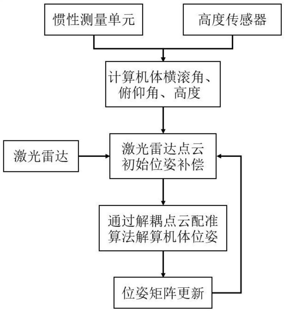
[0074] Such as figure 1 As shown, the present invention provides a fast and robust SLAM method for three-dimensional lidar, comprising the following steps:

[0075] Step 1. Collect inertial sensor and height sensor data, and calculate the roll angle, pitch angle and height of the body coordinate system relative to the global coordinate system at the current moment;

[0076] Step 2. Collect lidar point cloud data and perform pose compensation on the lidar point cloud;

[0077] Step 3. Use the point cloud after pose compensation in step 2 to calculate the decoupled point cloud registration algorithm, and calculate the six-degree-of-freedom pose of the body at the current moment;

[0078] Step 4: Update the pose matrix according to the update conditions of the SLAM framework, and pass the result to step 2.

[0079] Further, step 1 specifically includes:

[0080] Step 11. According to the inertial sensor and altitude sensor data, the pose matrix of the computer system relative ...


PUM


Abstract

The invention discloses a three-dimensional laser radar rapid robust SLAM method and device, and the method employs a height sensor and an inertial measurement unit to carry out information assistance on a laser radar, compensates the initial pose of a laser radar point cloud before point cloud registration, and achieves the six-degree-of-freedom navigation calculation of a UAV through a decoupling three-dimensional laser radar point cloud registration algorithm. Compared with a traditional laser SLAM algorithm, the invention has the advantages that height calculation errors and horizontal coupling errors caused by point cloud excessive matching are effectively restrained, the pose estimation precision of the UAV in a complex environment is improved, and higher calculation efficiency is achieved.

Description

technical field [0001] The invention belongs to the field of integrated navigation, in particular to a fast and robust SLAM method and device for three-dimensional laser radar, and in particular to a three-dimensional laser radar decoupling SLAM method and device for a micro-small aircraft (UAV) in a complex environment. Background technique [0002] Simultaneous localization and mapping (SLAM, Simultaneous Localization and Mapping) technology is a major research hotspot in the field of robot autonomous navigation technology. In an environment without GPS (Global Positioning System), the SLAM method can help robots realize navigation and positioning in unfamiliar environments, and is a key technology in the practical application of robots. [0003] In the SLAM algorithm, the pose of the body is determined by iteratively matching two frames of point clouds and finding the relative pose relationship between the two frames of point clouds. Usually, the multivariate normal trans...

Claims


Application Information

Patent Timeline
IPC IPC(8): G06T7/73G01S17/88G01S17/89G01S17/86
CPCG06T7/73G01S17/88G01S17/89G01S17/86G06T2207/10028G06T2207/10044Y02T10/40
Inventor 吕品温烨贝赖际舟何洪磊李志敏
Owner NANJING UNIV OF AERONAUTICS & ASTRONAUTICS
Why Eureka
Try Eureka