Seabed datum point position calibration system and method

A reference point and calibration technology, which is applied in the satellite radio beacon positioning system, radio wave measurement system, positioning, etc., can solve the problems of low efficiency, many repetitions, and long cycle, so as to save test time and resources, improve The effect of experimental efficiency

Active Publication Date: 2021-08-06
HARBIN ENG UNIV
View PDF5 Cites 0 Cited by
  • Summary
  • Abstract
  • Description
  • Claims
  • Application Information

AI Technical Summary

Problems solved by technology

[0004] The purpose of the present invention is to provide a seabed reference point position calibration system and method in order to ove

Method used


Image

  • Seabed datum point position calibration system and method
  • Seabed datum point position calibration system and method
  • Seabed datum point position calibration system and method

Examples


Example Embodiment

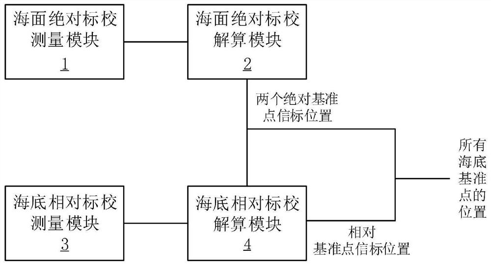
[0039] DETAILED DESCRIPTION First, in the following embodiment of the submarine reference point position, such as figure 1 The system workfinder block, the system includes: sea surface absolute standards measurement module 1 for sea vessel and absolute reference point signaling interposer information interaction; sea surface absolute standard gravity module 2, used to solve two absolute reference information The coordinates labeled under the geodetic coordinate system; the seabed relative to the standard module 3, which is used for the absolute reference point enclosure and adjacent relative reference doctrine between information interaction; the underlayer relative to the standard decision module 4 for solving The coordinates of all relative reference points in the gear coordinate system.

[0040] Among them, the submarine reference point entries include: buoyancy devices, water-acoustic transducers, withstand voltage housings, electronic compatibilities, battery compartment, aco...

Example Embodiment

[0045] BEST MODE FOR CARRYING OUT THE INVENTION Second, the second embodiment of the second embodiment includes the following steps: figure 2 Distance

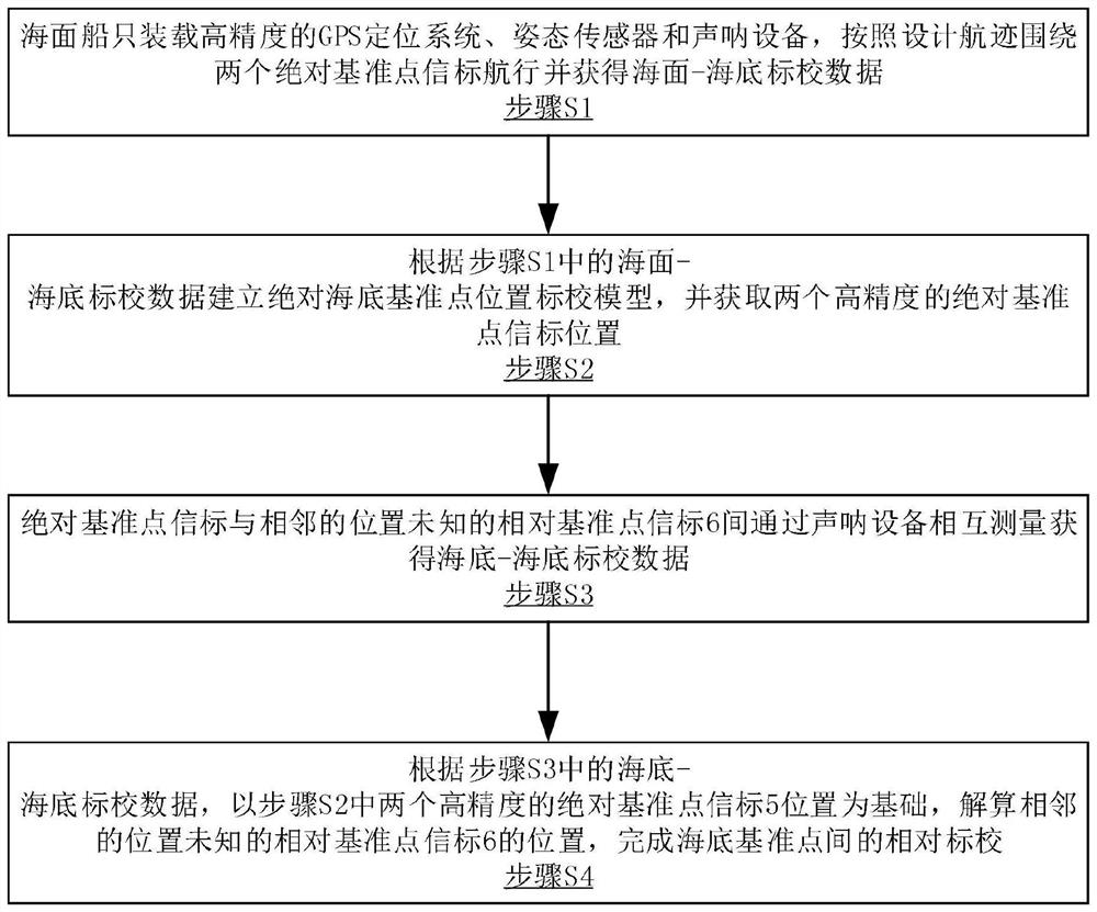
[0046] Step S1, the sea vessel loads high-precision GPS positioning system, attitude sensors and sonar equipment, sailing around two absolute reference points in the design of the design, and obtains the sea - seawato data data;

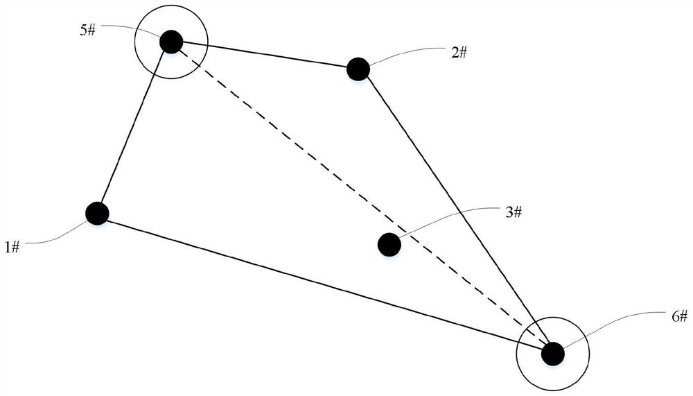
[0047] Step S2, establish an absolute submarine reference point position scalar model based on the sea surface-submarine data data in step S1, and obtain two high-precision absolute reference points beacon 5 position;

[0048] Step S3, the absolute reference point beacon and the adjacent position unknown relative reference point beacon 6 are measured by the sonar device to obtain the submarine-semicachiographic data data;

[0049] Step S4, based on the seabed-semicar circuit data data in step S3, the position of the adjacent position unknown relative reference point beacon 6 is solved by the position of ...


PUM


Abstract

The invention discloses a seabed reference point position calibration system and method, relates to the field of marine surveying and mapping, and aims at solving the problems that an existing seabed reference point position calibration method is long in period, low in efficiency and high in repetition frequency.The system comprises: a sea surface absolute calibration measurement module which sails around an absolute reference point beacon, and obtains sea surface-seabed calibration data; a sea surface absolute calibration resolving module which receives sea surface-seabed calibration data and calculates the coordinates of the two absolute reference point beacons in a geodetic coordinate system; a seabed relative calibration measurement module which is used for measuring and obtaining seabed-seabed calibration data; and a seabed relative calibration calculation module which is connected with the sea surface absolute calibration calculation module and the seabed relative calibration measurement module at the same time, and coordinates of all relative reference point beacons in the geodetic coordinate system are obtained through calculation.

Description

Technical field [0001] The present invention relates to the field of marine surveying and mapping. Background technique [0002] The marine earth measurement benchmark is the basic reference framework of marine environment information is the important foundation for the national planning and implementation of all marine strategies. In an environment based on vigorous development of the ocean, it is especially important to strengthen the monitoring of the marine environment. The construction of the seabed benchmark is an important part of the marine earth measurement benchmark. It is also an important part of the global benchmark. One of the difficulties is in the precise positioning of the seabed reference point. [0003] The method of the existing sea-shelf point position is based on the basement of the seabed, and the seas and vessels are saved around the absolute standard along the specific trajectory, but this absolute standard school is long and the efficiency is low, and th...

Claims


Application Information

Patent Timeline
IPC IPC(8): G01C13/00G01S5/30G01S19/48
CPCG01C13/00G01S5/30G01S19/48
Inventor 孙大军郑翠娥张居成韩云峰崔宏宇张殿伦
Owner HARBIN ENG UNIV
Why Eureka
Try Eureka