A remote supercomputing method for gnss data

A data and remote technology, applied in the direction of instruments, measuring devices, electrical components, etc., to achieve the effect of not being limited by hardware, saving hardware costs, operating system costs, solidifying software costs, and reducing observation time

Active Publication Date: 2021-09-28
四川中科川信科技有限公司
View PDF16 Cites 0 Cited by
  • Summary
  • Abstract
  • Description
  • Claims
  • Application Information

AI Technical Summary

Problems solved by technology

[0003] The purpose of the present invention is to solve the problem of GNSS data calculation, and propose a remote over-computing method for GNSS data

Method used


Image

  • A remote supercomputing method for gnss data
  • A remote supercomputing method for gnss data
  • A remote supercomputing method for gnss data

Examples


Embodiment Construction

[0054]Embodiments of the present invention will be further described below in conjunction with the accompanying drawings.

[0055] Before describing the specific embodiments of the present invention, in order to make the scheme of the present invention more clear and complete, at first the abbreviations and key term definitions that appear in the present invention are explained:

[0056] CRC check: Cyclic redundancy check code, cyclic code for short, is a commonly used check code with error detection and error correction capabilities.

[0057] ttag: tag indicates a tag, and ttag indicates that the second of the week is used as the time scale, which belongs to the common knowledge of those skilled in the art.

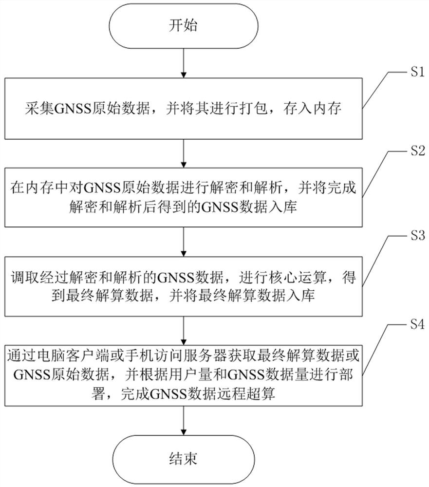
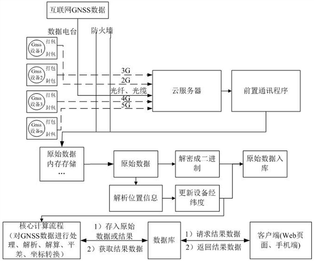
[0058] Such as figure 1 As shown, the present invention provides a kind of GNSS data long-distance overcomputing method, comprises the following steps:

[0059] S1: collect GNSS raw data, pack it and store it in memory;

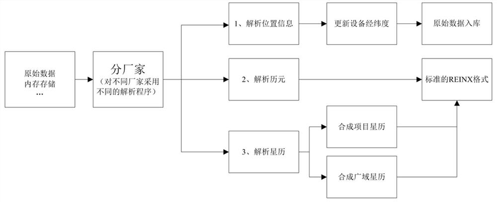
[0060] S2: Decrypt and analyze the GNSS raw da...


PUM


Abstract

The invention discloses a remote supercomputing method for GNSS data, which comprises the following steps: S1: collect GNSS original data, pack it, and store it in memory; S2: decrypt and analyze the GNSS original data in memory, and The GNSS data obtained after decryption and analysis is completed and stored in the database; S3: Call the decrypted and analyzed GNSS data, perform core calculations, obtain the final solution data, and store the final solution data in the database; S4: Through the computer client or The mobile phone accesses the server to obtain the final solution data or GNSS raw data, and performs single-server deployment, multi-server deployment or cloud service deployment according to the number of users and GNSS data volume, and completes remote overcomputing of GNSS data. The supercomputing method of the present invention is compatible with GNSS data formats of all manufacturers and all types of Cors reference system data, and supports conversion between different GNSS data formats.

Description

technical field [0001] The invention belongs to the technical field of GNSS data processing, and in particular relates to a remote supercomputing method for GNSS data. Background technique [0002] In the field of high-precision location services, it is mainly realized by relying on the global navigation satellite system (GNSS) technology. By establishing a satellite navigation and positioning reference station system (continuously operating reference stations, CORS) to observe GNSS satellite information in real time and continuously, it can quickly Effectively weaken the main error effects of orbit, clock error and atmosphere, so as to achieve real-time centimeter-level and post-event millimeter-level precision positioning. GNSS-based deformation monitoring, surveying and mapping navigation, tracking and positioning, etc. all have a great demand for high-precision level (millimeter level) location services. General units do not have the service conditions, the main reasons...

Claims


Application Information

Patent Timeline
Patent Type & Authority Patents(China)
IPC IPC(8): G01S19/37H04L29/06H04W12/03
CPCG01S19/37H04L63/0428
Inventor 王世敏王鑫磊梁小燕周欣黄蓥刘彪付勇皓
Owner 四川中科川信科技有限公司
Why Eureka
Try Eureka