
Remote sensing image optimization method and device

A remote sensing image and image technology, applied in the field of satellite remote sensing, can solve problems such as the lack of actual cloud coverage area space range, restrict the commercial application of satellite remote sensing technology, and reduce the application value of satellite remote sensing data, so as to promote the operational application ability and improve Optimize query efficiency and reduce the effect of data storage

Active Publication Date: 2021-11-26
MINISTRY OF ECOLOGY & ENVIRONMENT CENT FOR SATELLITE APPL ON ECOLOGY ENVIRONMENT
View PDF10 Cites 0 Cited by
  • Summary
  • Abstract
  • Description
  • Claims
  • Application Information

AI Technical Summary

Problems solved by technology

[0008] 1. The result of traditional image query is a large and comprehensive data list, which can only manually select effective images, which consumes manpower and material resources. For large-scale image selection, there are often problems of multiple selection and missing selection, and it is impossible to use computers to search through images. Spatial query of effective area can get accurate data in the required range, and the query efficiency is low
[0009] 2. The cloud amount in the traditional image metadata is a statistical value, and there is no spatial range of the actual cloud coverage area
The traditional image query method is inefficient, reduces the real-time application value of satellite remote sensing data, and restricts the commercial application of satellite remote sensing technology to a certain extent

Method used


Image

  • Remote sensing image optimization method and device
  • Remote sensing image optimization method and device
  • Remote sensing image optimization method and device

Examples


Embodiment 1

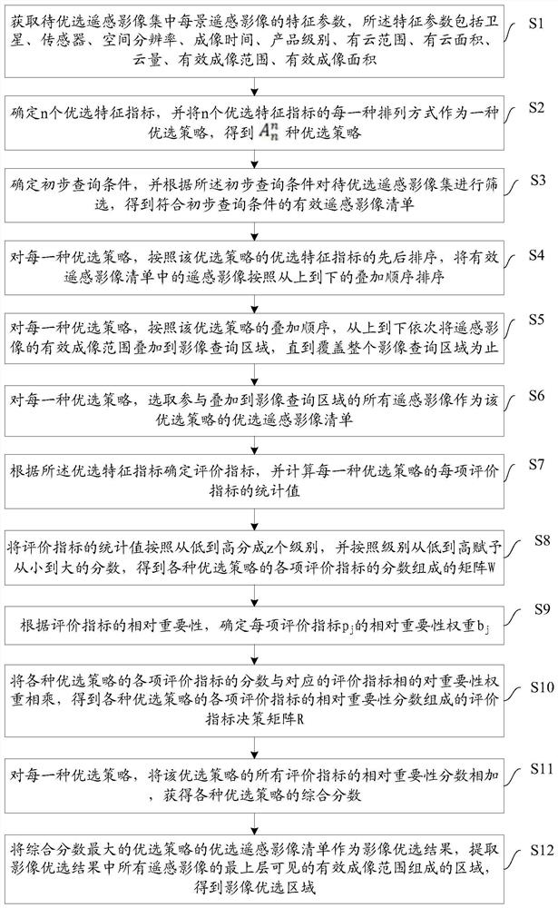
[0100] An embodiment of the present invention provides a remote sensing image optimization method, such as figure 1 As shown, the method includes:

[0101] S1: Obtain the characteristic parameters of each remote sensing image in the remote sensing image set to be optimized. The characteristic parameters include satellite, sensor, spatial resolution, imaging time, product level, cloud range, cloud area, cloud amount, effective imaging range, effective imaging area.

[0102] This step is used to preprocess and standardize the satellite remote sensing images to obtain the preferred characteristic parameters of the remote sensing images. A specific implementation of this step can be as follows:

[0103] S101: Perform standardized processing on the remote sensing image, and obtain parameters such as satellite, sensor, imaging time, spatial resolution, and product level among the characteristic parameters through the metadata information of the remote sensing image.

[0104] S102: P...

Embodiment 2

[0179] An embodiment of the present invention provides a remote sensing image optimization device, such as Figure 5 As shown, the device includes:

[0180] The preprocessing module 1 is used to obtain the characteristic parameters of each remote sensing image in the remote sensing image set to be optimized. The characteristic parameters include satellite, sensor, spatial resolution, imaging time, product level, cloud range, cloud area, cloud amount, effective Imaging range, effective imaging area.

[0181] The optimal strategy determination module 2 is used to determine n optimal feature indexes, and each arrangement of the n optimal feature indexes is used as an optimal strategy to obtain a preferred strategy.

[0182] The preliminary query module 3 is used to determine the preliminary query conditions, and screen the remote sensing image set to be selected according to the preliminary query conditions to obtain a list of effective remote sensing images that meet the prel...


PUM


Abstract

The invention discloses a remote sensing image optimization method and device, belonging to the field of remote sensing. This method first preprocesses and standardizes remote sensing images to obtain image feature parameters; combined with optimal feature indicators, constructs an image optimization strategy model based on a decision tree; uses preliminary query conditions for the first query to quickly obtain a list of all valid remote sensing images; The image optimization strategy model performs the second spatial composite operation query to obtain the accurate optimal remote sensing image list; calculates the evaluation index of the optimal remote sensing image list for each optimal strategy to form an index evaluation decision matrix; uses the evaluation index decision matrix to select the most The optimal image selection result; obtain the optimized image list, and obtain the vector boundary and information of the optimized image optimal area. The invention realizes automatic and fast optimization of massive satellite remote sensing images in a large area, greatly saves manpower, material resources, and financial resources, and improves the optimal query efficiency of massive satellite remote sensing images.

Description

technical field [0001] The invention relates to the field of satellite remote sensing, in particular to a remote sensing image optimization method and device. Background technique [0002] With the development of earth observation technology, human beings' ability to comprehensively observe the earth has reached an unprecedented level. Satellite remote sensing image data has the characteristics of multi-source, multi-scale, large data volume, and wide application. The field of satellite remote sensing has entered the era of big data. At the same time, the application field of satellite remote sensing data is continuously expanding. The demand for query and retrieval continues to increase. [0003] Due to the limited resources of a single satellite and the limited coverage of a single-view remote sensing image, it is often necessary to mosaic multiple remote-sensing images into an image covering a larger area. At the same time, affected by cloudy and rainy weather, especial...

Claims


Application Information

Patent Timeline
Patent Type & Authority Patents(China)
IPC IPC(8): G06F16/583G06T7/00
CPCG06T7/0002G06T2207/10032G06T2207/30168G06F16/583
Inventor 史园莉申文明张文国王丽霞张宏伟申振徐丹孙中平蔡明勇高乾毕晓玲马万栋曹飞孙浩
Owner MINISTRY OF ECOLOGY & ENVIRONMENT CENT FOR SATELLITE APPL ON ECOLOGY ENVIRONMENT
Learn More