Fusion method based on multi-source heterogeneous space planning data

A space planning, multi-source heterogeneous technology, applied in the direction of structured data retrieval, database update, electronic digital data processing, etc., can solve the problems of land space planning data format, coordinate reference, attribute structure differences, etc.

Active Publication Date: 2021-09-24
GUANGDONG URBAN & RURAL PLANNING & DESIGN INST
View PDF8 Cites 12 Cited by
  • Summary
  • Abstract
  • Description
  • Claims
  • Application Information

AI Technical Summary

Problems solved by technology

[0005] Aiming at the problem of differences in format, coordinate reference, attribute structure, etc. of land space planning data from different sources, the present invention proposes a fusion method of multi-source heterogeneous space planning data, which is mainly used in land space planning

Method used


Image

  • Fusion method based on multi-source heterogeneous space planning data
  • Fusion method based on multi-source heterogeneous space planning data
  • Fusion method based on multi-source heterogeneous space planning data

Examples


Embodiment Construction

[0030] In order to make the object, technical solution and advantages of the present invention more clear and definite, the present invention will be further described below with reference to the accompanying drawings and examples. Based on the embodiments of the present invention, all other embodiments obtained by persons of ordinary skill in the art without making creative efforts belong to the protection scope of the present invention.

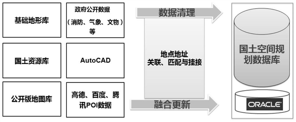
[0031]Aiming at the problem of differences in formats, coordinate references, attribute structures, etc. of land space data from different sources, the present invention provides a planning data fusion method based on multi-source heterogeneous space, which is mainly applied to land space planning data. The method is mainly after data access and before data application, based on the existing national land resource database, public map database, basic surveying and mapping database and other self-owned data, data cleaning and fusion are carri...


PUM


Abstract

The invention discloses a fusion method based on multi-source heterogeneous space planning data. The fusion method comprises the following steps: S1, GIS data processing and fusion; S2, carrying out AutoCAD data processing and conversion; S3, matching and hooking place names and addresses; and S4, carrying out batch processing. Territorial space planning data from different sources can be efficiently and rapidly read and processed, data redundancy is eliminated, the purpose of data deduplication is achieved, the data processing capacity can be improved to the maximum extent, and the efficiency is improved. According to the method, natural laws and social economic laws of territorial space pattern differentiation are scientifically known through an intelligent data processing and analysis tool, so that territorial space function regions are efficiently divided, and key basic work of territorial space planning is facilitated.

Description

technical field [0001] The invention relates to the technical field of resource planning, in particular to a fusion method for land resources based on multi-source heterogeneous land space planning data. Background technique [0002] Land space planning is a scientific guide to guide the development of national space. It coordinates all kinds of spatial planning and promotes the strategic deployment of "integration of multiple plans". important step in construction. Since land spatial planning data is the summary and integration of land planning results, it is an important embodiment of land planning information management. After years of accumulation, these data show multi-source, heterogeneous, multi-time and space, multi-scale, and different coordinate systems This has led to the problem of multi-source data for land planning, such as data duplication, due to the regularity of time-series data, which makes it very redundant. In addition, there are currently a large numbe...

Claims


Application Information

Patent Timeline
Patent Type & Authority Applications(China)
IPC IPC(8): G06F16/29G06F16/25G06F16/23G06F16/215G06F40/289
CPCG06F16/29G06F16/254G06F16/258G06F16/256G06F16/215G06F16/23G06F40/289
Inventor 邱衍庆王晖阮浩德陈静马星潘俊钳胡琼马力吴进修
Owner GUANGDONG URBAN & RURAL PLANNING & DESIGN INST
Why Eureka
Try Eureka