High-precision road shortest path calculation method based on surveying and mapping information

A shortest-path, high-precision technology, applied in surveying and navigation, navigation calculation tools, road network navigators, etc., can solve problems such as grid modeling and path planning that cannot be solved

Active Publication Date: 2021-09-28
湖南汇视威智能科技有限公司
View PDF4 Cites 1 Cited by
  • Summary
  • Abstract
  • Description
  • Claims
  • Application Information

AI Technical Summary

Problems solved by technology

Many of these algorithms, such as A-star, Dijkstra, and artificial potential field methods, can be used to calculate the shortest path, but they cannot solve large-scale and high-precision grid modeling and path planning in three-dimensional space under limited memory. The problem is that for the speed measurement interval, the spatial span is often more than several kilometers, and the width is generally about ten meters. Therefore, the shortest path planning requires the use of fine-grained grids. Taking the planning interval of 2km*2km as an example, its Modeling at the millimeter level will result in a grid size of 4 trillion. It is difficult to directly perform high-precision shortest path planning on this scale.

Method used


Image

  • High-precision road shortest path calculation method based on surveying and mapping information
  • High-precision road shortest path calculation method based on surveying and mapping information

Examples


Embodiment Construction

[0027] The present invention will be further described below in conjunction with the accompanying drawings and specific embodiments.

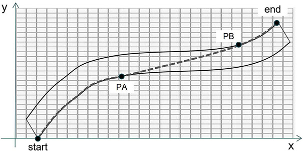
[0028] figure 1 is a schematic diagram of the shortest path constructed in the present invention. The general road space can be composed of several illustrated curves, wherein the dotted line shows the shortest path obtained in step 5, start and end are respectively the designated starting point and end point of the road, start, The line segment between the two points of PA and the line segment between PB and end are the edge segments described in step 6, while the line segment between the two points of PA and PB is the jump segment, as described in step 6, the edge segment and the road The edges coincide, and the jumps are straight lines.

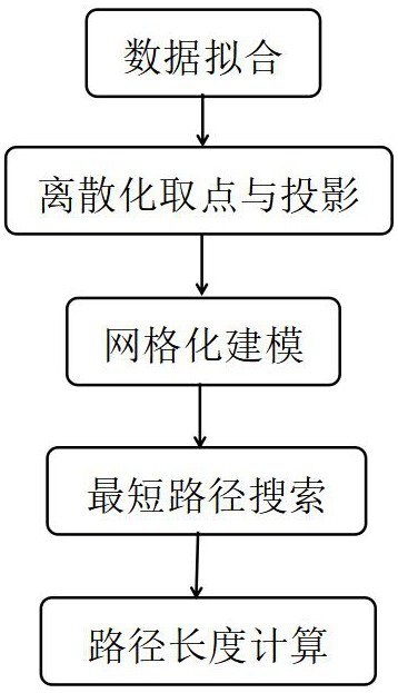
[0029] figure 2 It is a flowchart of the shortest path calculation method constructed in the present invention, including the following links: 1. Data fitting, that is, as described in step 1, fitting ac...


PUM


Abstract

The invention belongs to the field of path planning, and discloses a high-precision road shortest path calculation method based on surveying and mapping information. According to the method, discrete road surveying and mapping information is drawn into a smooth space curved surface through a curve fitting method, and a high-precision shortest path search algorithm under a large-scale smooth curved surface is constructed based on a modified Dijkstra algorithm by utilizing the characteristic of the shortest path of the smooth space curved surface under two-dimensional projection. And the shortest path on the plane is further mapped to the original spatial curved surface to accurately calculate the path length. According to the method, the problem that high-precision shortest path calculation is carried out under the large-scale smooth space curved surface through a traditional path planning algorithm is solved, and the calculation error of the shortest path under the large-scale smooth space curved surface can be controlled within 0.05%.

Description

technical field [0001] A high-precision road shortest path calculation method based on surveying and mapping information. The invention belongs to the field of path planning, and relates to a high-precision path planning method based on grid modeling in a large-scale space under limited memory, especially based on road surveying and mapping information. The high-precision path planning method and the shortest distance calculation method under the smooth space surface of the above-mentioned method can be used for grid modeling and path search based on the road information based on surveying and mapping data, and the shortest path distance in the road can be calculated. Background technique [0002] With the advancement of my country's modernization, the expressway network is also being continuously improved. As of 2020, the total length of expressway sections in China has exceeded 160,000 kilometers, and the number of expressway traffic is even more difficult to estimate. Take...

Claims


Application Information

Patent Timeline
Patent Type & Authority Applications(China)
IPC IPC(8): G01C21/34G01C21/20
CPCG01C21/343G01C21/20
Inventor 胡亚清顾善植蓝丹吴瑶王聪睿殷悦王明兴杨石梦
Owner 湖南汇视威智能科技有限公司
Why Eureka
Try Eureka