
Remote sensing image terrain correction effect evaluation method based on entropy weight method

A terrain correction and remote sensing image technology, applied in image enhancement, image analysis, image data processing, etc., can solve the problems of terrain correction effect gap, evaluation result dependence, inability to evaluate the whole image, etc., to improve the effect and improve the accuracy Effect

Pending Publication Date: 2021-11-02
WUHAN UNIV OF TECH
View PDF0 Cites 0 Cited by
  • Summary
  • Abstract
  • Description
  • Claims
  • Application Information

AI Technical Summary

Problems solved by technology

[0006] A single quantitative evaluation index of terrain correction effect can only evaluate the effect of terrain correction from a single angle of image, so the evaluation result depends on the selected evaluation index
At the same time, remote sensing images are often combined in the form of multiple bands, and the current terrain correction effect evaluation indicators can only obtain the evaluation results of a single band. Most scholars use the single-band terrain correction evaluation results to replace the evaluation results of remote sensing images.
However, there is an obvious gap in the terrain correction effect between the various bands of remote sensing images, so the evaluation results of a single band cannot effectively evaluate the entire image

Method used


Image

  • Remote sensing image terrain correction effect evaluation method based on entropy weight method
  • Remote sensing image terrain correction effect evaluation method based on entropy weight method
  • Remote sensing image terrain correction effect evaluation method based on entropy weight method

Examples


Embodiment Construction

[0074] The inventors of the present application have found through extensive research and practice that a single quantitative evaluation index for terrain correction effects can only evaluate terrain correction effects from a single angle of image, so the evaluation results depend on the selected evaluation index. At the same time, remote sensing images are often combined in the form of multiple bands, and the current terrain correction effect evaluation indicators can only obtain the evaluation results of a single band. Most scholars use the single band terrain correction evaluation results to replace the evaluation results of remote sensing images. However, there is an obvious gap in the terrain correction effect between the various bands of the remote sensing image, so the evaluation results of a single band cannot effectively evaluate the entire image. In summary, it is obviously irrational to use a single index and a single band to evaluate the terrain correction effect. I...


PUM


Abstract

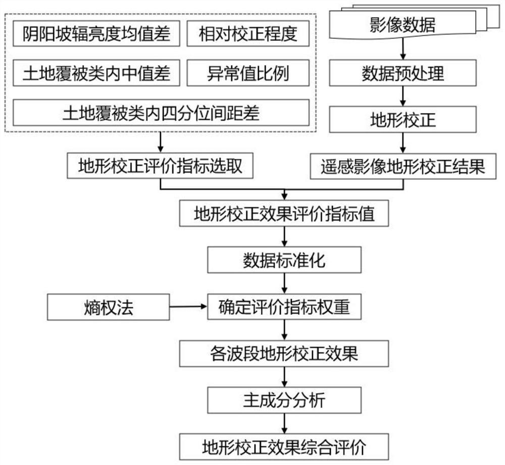
The invention provides a remote sensing image terrain correction effect evaluation method based on an entropy weight method. The remote sensing image terrain correction effect evaluation method comprises the following steps: 1, obtaining a quantitative evaluation index of a remote sensing image terrain correction effect; 2, performing quantitative evaluation on the remote sensing image after topographic correction from five aspects by using quantitative evaluation indexes; 3, standardizing each quantitative evaluation index value; 4, obtaining a terrain correction effect comprehensive evaluation value of each wave band based on an entropy weight method; and 5, calculating a comprehensive score of the terrain correction effect of the whole image based on a principal component analysis method. According to the method, the terrain correction effect of the remote sensing image can be comprehensively and objectively quantitatively evaluated, and the defect that the terrain correction effect is evaluated by adopting a single evaluation index and a single wave band at present is overcome.

Description

technical field [0001] The invention relates to the technical field of remote sensing image preprocessing, in particular to a method for evaluating the terrain correction effect of remote sensing images based on an entropy weight method. Background technique [0002] The solar radiation received by the surface of complex terrain is affected by many factors such as the sun, atmosphere and topography, resulting in the non-uniformity of solar radiation energy received by the surface. The remote sensing images obtained in this area are affected by the terrain fluctuations, that is, the slope and aspect variations, resulting in differences in the radiance of image elements on the shady and sunny slopes. This terrain effect seriously affects the quantitative analysis of remote sensing images. In order to obtain the real spectral information of the target, it is necessary to perform terrain correction on the image to eliminate the influence of terrain. [0003] Since the 1980s, sc...

Claims


Application Information

Patent Timeline
Patent Type & Authority Applications(China)
IPC IPC(8): G06T5/00G01N21/25G06K9/62
CPCG01N21/25G01N2021/1793G06T2207/10032G06F18/2135G06T5/00
Inventor 黄解军姚明坤况路路唐盼丽张明
Owner WUHAN UNIV OF TECH
Learn More