Unmanned aerial vehicle emergency processing method and system, storage medium and electronic equipment

An emergency treatment and unmanned aerial vehicle technology, applied in the field of unmanned aerial vehicles, can solve the problems of casualties, inaccuracy, unsafe statistics, etc., achieve the effects of improving efficiency and accuracy, avoiding double counting, and saving resources

Pending Publication Date: 2021-11-05
INST OF GEOGRAPHICAL SCI & NATURAL RESOURCE RES CAS
View PDF9 Cites 3 Cited by
  • Summary
  • Abstract
  • Description
  • Claims
  • Application Information

AI Technical Summary

Problems solved by technology

In the prior art, the path generation technology for rescuing the victims does not combine the features of the landform, which leads to inaccurate path planning. In addition, it does not make full use of the characteristics of UAVs that can obtain data without injury in the air. It is not safe to ma

Method used


Image

  • Unmanned aerial vehicle emergency processing method and system, storage medium and electronic equipment
  • Unmanned aerial vehicle emergency processing method and system, storage medium and electronic equipment

Examples


Embodiment 1

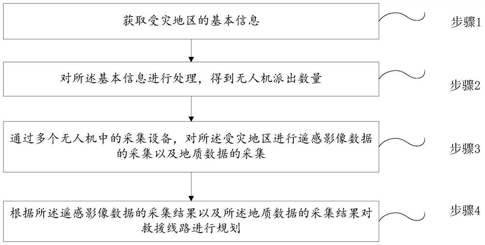
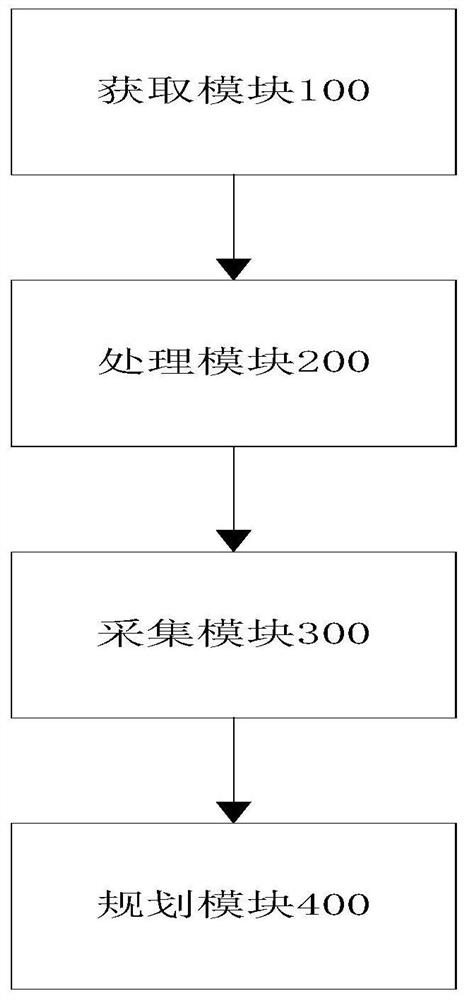
[0050] Embodiment 1. After receiving the request for support information, the rescue command center calls the processor to obtain basic information including the disaster location, disaster type, and disaster scope, and plans the disaster scope through the multi-factor maximum coverage model to obtain the unmanned personnel that need to be dispatched. The number of drones is controlled. After the drones arrive at their designated locations, the drones will collect data from the disaster-stricken area through their own collection equipment, including remote sensing image data and geological data. The collected data is input into the pre-established prediction model to obtain the data information of the road sections with risks in the disaster-stricken area, and after integrating the data information of the road sections with risks, a safe and shortest rescue path that avoids the risky sections is obtained.

[0051] Preferably, in any of the above-mentioned embodiments, the basic...

Embodiment 2

[0060] Embodiment 2, after receiving the request for support information, the rescue command center invokes the processor to obtain basic information including the disaster location, disaster type, and disaster scope, and plans the disaster scope through the multi-factor maximum coverage model to obtain the unmanned personnel that need to be dispatched. The number of drones is controlled. After the drones arrive at their designated locations, the drones will collect data from the disaster-stricken area through their own collection equipment, including remote sensing image data and geological data. Input the collected data into the pre-established prediction model to obtain the data information of the road sections with risks in the disaster-affected area. After integrating the data information of the road sections with risks, input them into the pre-established optimal path generation model to obtain the optimal route generation model. The optimal path will be sent to the rescu...

Embodiment 3

[0064] Embodiment 3, after receiving the request for support information, the rescue command center invokes the processor to obtain basic information including the disaster location, disaster type, and disaster scope, and plans the disaster scope through the multi-factor maximum coverage model to obtain the unmanned personnel that need to be dispatched. The number of drones is controlled. After the drones arrive at their designated locations, the drones will collect data from the disaster-stricken area through their own collection equipment, including remote sensing image data and geological data. Input the collected data into the pre-established prediction model to obtain the data information of the road sections with risks in the disaster-affected area. After integrating the data information of the road sections with risks, input them into the pre-established optimal path generation model to obtain the first The optimal path, and send the first optimal path to the rescue comm...


PUM


Abstract

The invention relates to the field of unmanned aerial vehicles and particularly relates to an unmanned aerial vehicle emergency processing method and system, a storage medium and electronic equipment. The method comprises the following steps of 1, acquiring the basic information of an affected area; 2, processing the basic information to obtain the number of dispatched unmanned aerial vehicles; 3, remote sensing image data and geological data of the affected area being acquired through acquisition equipment in a plurality of unmanned aerial vehicles; and 4, planning a rescue route according to the acquisition result of the remote sensing image data and the acquisition result of the geological data. Through the method, casualties can be avoided in the acquisition process, on the other hand, disaster landform conditions can be more comprehensively acquired through high-altitude data acquisition, rescue workers can be effectively ensured to arrive at a rescue site in time by planning a rescue route according to an acquisition result, casualties of the disaster workers are reduced, and meanwhile, safety of rescue workers is ensured.

Description

technical field [0001] The invention relates to the field of unmanned aerial vehicles, in particular to an emergency treatment method, system, storage medium and electronic equipment for unmanned aerial vehicles. Background technique [0002] The damage caused by natural disasters such as forest fires and mudslides is immeasurable, and it is even more difficult if the affected area includes buildings, etc. Therefore, it is particularly important for the rescue of victims in disasters and post-disaster reconstruction. In the prior art, the path generation technology for rescuing the victims does not combine the features of the landform, which leads to inaccurate path planning. In addition, it does not make full use of the characteristics of UAVs that can obtain data without injury in the air. It is not safe to manually count landforms or disaster-affected areas, and manual statistics are neither comprehensive nor accurate. Analyzing historical data cannot deal with the ever-...

Claims


Application Information

Patent Timeline
IPC IPC(8): G05D1/10
CPCG05D1/101
Inventor 岳焕印叶虎平廖小罕
Owner INST OF GEOGRAPHICAL SCI & NATURAL RESOURCE RES CAS
Why Eureka
Try Eureka