Image tile map service method based on triple bidirectional indexing and optimal caching

A two-way index and tile map technology, applied in the fields of retrieval and browsing, and the organization and management of remote sensing images, can solve the problems of lack of rich and convenient indexes, response speed and unbalanced coordination of occupied space, and achieve flexible index access methods and efficient access. and application, the effect of reducing workload

Active Publication Date: 2021-11-09
MINISTRY OF ECOLOGY & ENVIRONMENT CENT FOR SATELLITE APPL ON ECOLOGY ENVIRONMENT
View PDF9 Cites 6 Cited by
  • Summary
  • Abstract
  • Description
  • Claims
  • Application Information

AI Technical Summary

Problems solved by technology

[0007] In view of the urgent need for portable remote sensing image map services in the field of remote sensing monitoring and the shortcomings of the above-mentioned current remote sensing image map service technologies, research is conducted on the establishment of a mutual bidirectional index and Optimize the remote sensing image tile map service method of caching technology, focusing on solving the problem of unbalanced coordination between the response speed and occupied space of the current remote sensing image map service that lacks the support of rich and convenient metadata and full cache and real-time cache

Method used


Image

  • Image tile map service method based on triple bidirectional indexing and optimal caching
  • Image tile map service method based on triple bidirectional indexing and optimal caching
  • Image tile map service method based on triple bidirectional indexing and optimal caching

Examples


Embodiment Construction

[0035] The following will clearly and completely describe the technical solutions in the embodiments of the present invention with reference to the accompanying drawings in the embodiments of the present invention. Obviously, the described embodiments are only some, not all, embodiments of the present invention. Based on the embodiments of the present invention, all other embodiments obtained by persons of ordinary skill in the art without making creative efforts belong to the protection scope of the present invention.

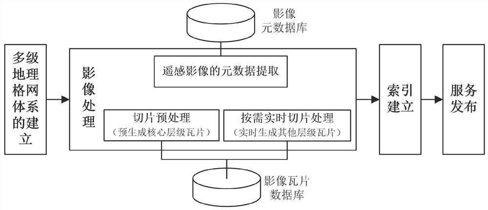
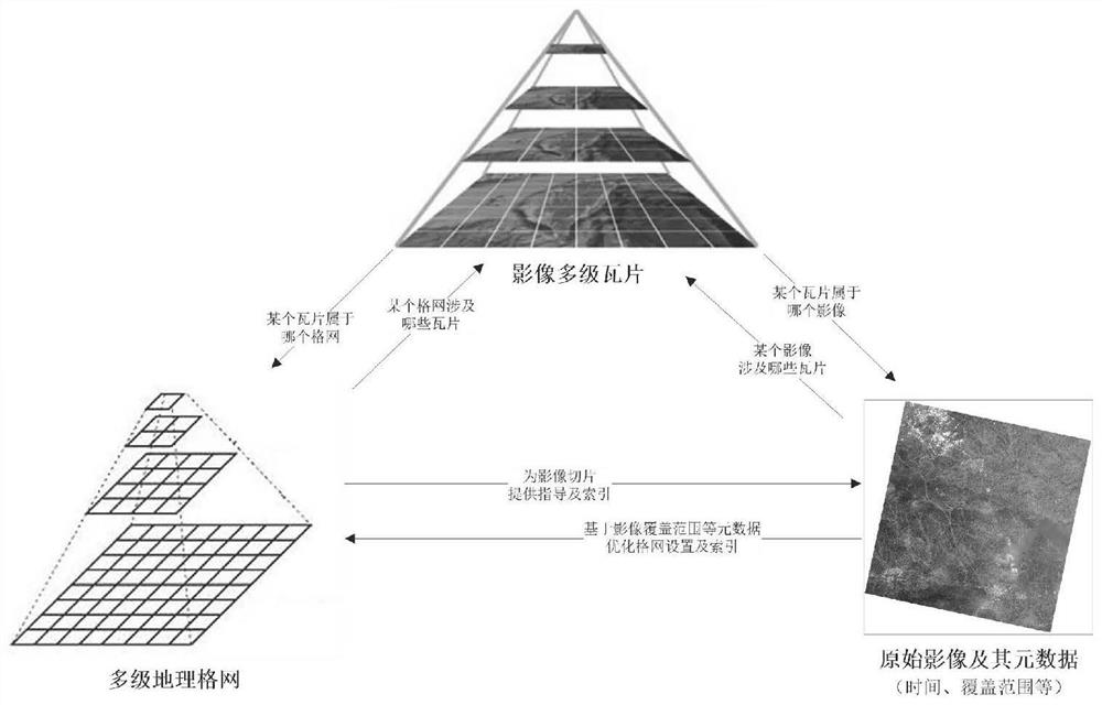
[0036] The embodiment of the present invention discloses an image tile map service method based on triple bidirectional index and optimized cache, such as figure 1 with figure 2 shown, including the following steps:

[0037] Establish a multi-level geographic grid system, in which the multi-level geographic grid system includes multiple layers of geographic grids, and number the geographic grids;

[0038] Extract the metadata of remote sensing images and st...


PUM


Abstract

The invention discloses an image tile map service method based on triple bidirectional indexing and optimal caching, and relates to the field of organization management and retrieval browsing of remote sensing images. Comprising the following steps: establishing a multi-level geographic grid system, and numbering geographic grids; extracting remote sensing image metadata and storing the remote sensing image metadata in a database; slicing the remote sensing image according to a multi-level geographic grid system and an optimized caching strategy to generate core-level tiles, and storing the core-level tiles in a database; establishing a bidirectional index of the triple; when a user request is received, retrieving the database according to the index, and if a requested tile exists, returning the tile and related metadata directly; if the tiles do not exist, forming the tiles in real time according to needs, returning and storing and the generated tiles and related metadata in a database. The indexing problem under the condition that remote sensing image map service lacks metadata support is solved, and the problems that full caching and real-time caching are unbalanced and coordinated in response speed and occupied space are solved.

Description

technical field [0001] The present invention relates to the field of organization management, retrieval and browsing of remote sensing images, and more specifically relates to a remote sensing image tile map based on {geographical grid, metadata, tile} triple mutual bidirectional indexing and optimized caching technology service method. Background technique [0002] With the rapid development of remote sensing technology, remote sensing image data has exploded. How to efficiently organize, manage, retrieve and browse these massive remote sensing data, so as to serve disaster emergency response, environment, resources, agriculture and other industries more conveniently and quickly, has become a very urgent common business demand and technical demand. [0003] The traditional organization, management and use of remote sensing images with "scene" as the unit has many problems such as various data formats, cumbersome files, and the need for professional software to open them, w...

Claims


Application Information

Patent Timeline
Patent Type & Authority Applications(China)
IPC IPC(8): G06F16/29G06F16/51G06F16/56G06F16/587
CPCG06F16/29G06F16/51G06F16/56G06F16/587
Inventor 肖如林侯鹏高吉喜张文国靳川平付卓闻瑞红王雪峰候静杨栩翟俊李营殷守敬高海峰陈妍
Owner MINISTRY OF ECOLOGY & ENVIRONMENT CENT FOR SATELLITE APPL ON ECOLOGY ENVIRONMENT
Why Eureka
Try Eureka