Navigation mark drift monitoring method based on remote sensing technology

A remote sensing technology and navigation mark technology, which is applied in the field of navigation mark drift monitoring, can solve the problems of limited application scope and high cost, and achieve the effect of ensuring navigation safety.

Pending Publication Date: 2021-11-26
SHANGHAI ADVANCED AVIONICS
View PDF0 Cites 0 Cited by
  • Summary
  • Abstract
  • Description
  • Claims
  • Application Information

AI Technical Summary

Problems solved by technology

[0007] The technical problem to be solved by the present invention is to provide a remote sensing technology-based navigation mark drif

Method used


Image

  • Navigation mark drift monitoring method based on remote sensing technology
  • Navigation mark drift monitoring method based on remote sensing technology
  • Navigation mark drift monitoring method based on remote sensing technology

Examples


Example Embodiment

[0020] The present invention will be further described below with reference to the accompanying drawings and embodiments.
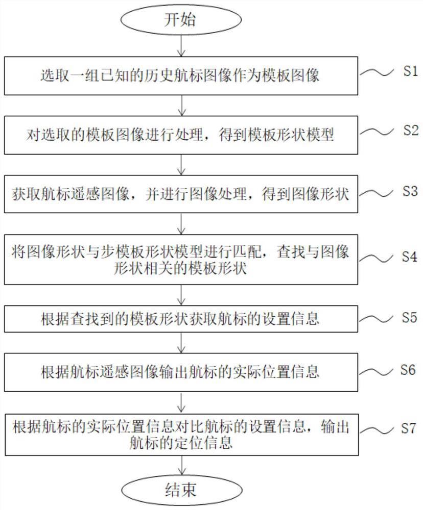
[0021] figure 1 This is a flow chart of the method for monitoring navigation mark drift based on remote sensing technology in the embodiment of the present invention.

[0022] See figure 1 , the remote sensing technology-based navigation mark drift monitoring method according to the embodiment of the present invention includes the following steps:

[0023] S1: Select a group of known historical navigation aid images as template images; the known historical navigation aid images are correspondingly recorded with the navigation aid numbers corresponding to the navigation aid images;

[0024] S2: Process the template image selected in step S1 to obtain a template shape model;

[0025] S3: Obtain the remote sensing image of the beacon, and perform image processing to obtain the shape of the image;

[0026] S4: Match the image shape obtained in step S3 wit...


PUM


Abstract

The invention discloses a navigation mark drifting monitoring method based on a remote sensing technology. The navigation mark drifting monitoring method comprises the following steps: selecting a group of known historical navigation mark images as template images; processing the selected template image to obtain a template shape model; acquiring a navigation mark remote sensing image, and processing the image to obtain an image shape; matching the image shape with the template shape model, and searching a template shape related to the image shape; acquiring the setting information of the navigation mark according to the searched template shape; outputting actual position information of the navigation mark according to the navigation mark remote sensing image; comparing the setting information of the navigation mark according to the actual position information of the navigation mark, and outputting the positioning information of the navigation mark. The known historical navigation mark image is used as the template image, the remote sensing image is collected to obtain the navigation mark AIS position, meanwhile, the remote sensing image is compared with the known historical navigation mark image to confirm the target navigation mark and obtain the target navigation mark setting information, and the current position and the deviation value of the navigation mark are accurately tested.

Description

technical field [0001] The invention relates to a navigation mark drift monitoring method, in particular to a navigation mark drift monitoring method based on remote sensing technology. Background technique [0002] The navigation mark is the abbreviation of the aid to navigation mark, which is a sign indicating the direction, boundary and obstruction of the navigation channel, and is also called a signal buoy. Including river crossing marks, coastal marks, guide marks, transition guide marks, head and tail guide marks, side marks, left and right navigation marks, position indicating marks, flood marks and bridge and culvert marks, etc. It is an artificial sign that helps guide the ship's navigation, locates and marks obstructions and expresses warnings. A navigation mark is an important navigational aid to mark the waterway for ships and reflect the size, direction and boundaries of the waterway. Therefore, each buoy is required to maintain accurate positioning, normal lig...

Claims


Application Information

Patent Timeline
IPC IPC(8): G06T7/73G06T7/13G06T7/55G06T5/00
CPCG06T7/73G06T7/13G06T5/002G06T7/55G06T2207/10032G06T2207/20016G06T2207/30181
Inventor 倪侃俊陈艾玲张国兴
Owner SHANGHAI ADVANCED AVIONICS
Why Eureka
Try Eureka