Multifunctional unmanned aerial vehicle remote sensing device for engineering surveying and use method

A technology of engineering measurement and machine remote sensing, which is applied in the direction of aircraft indicating devices, camera devices, unmanned aircraft, etc., and can solve the problems of remote sensor position adjustment affecting measurement results, inconvenient operation methods, and lack of measurement stability. , to achieve the effect of ensuring the effect of remote sensing measurement, ensuring the stability of descent or lift-off, and ensuring the safety

Pending Publication Date: 2021-12-28
广东省地质测绘研究院有限公司
View PDF6 Cites 0 Cited by
  • Summary
  • Abstract
  • Description
  • Claims
  • Application Information

AI Technical Summary

Problems solved by technology

[0006] In order to solve the above-mentioned technical problems, the present invention provides a multi-functional remote sensing device for engineering survey and its use method, to solve the problem that the existing remote sensing device for engineering survey is inconvenient to use and operate, and cannot be used for remote sensing. The position adjustment of the device affects the measurement effect, the poor protection effect affects the measurement stability and does not have the problem of high-altitude operation warning function. A multi-functional UAV remote sensing device for engineering measurement, including UAV body, wing, motor, propeller , a protective cover, a speed sensor, a support leg, a remote sensor, a rotary adjustable remote sensing detection rod structure, a UAV fall protection airbag structure and a high-altitude operation warning board structure. Wing; the outer bolt of the lower part of the wing is connected with a motor; the upper end of the output shaft of the motor is keyed with a propeller; the outer cover of the propeller is connected with a protective cover; the protective cover is connected with the outer end of the wing by bolts Setting; the outer four corners of the lower part of the drone body are all screw-connected with speed sensors; the four corners of the bottom of the drone body are all bolt-connected with support legs; the remote sensor is connected with the rotary adjustable remote sensing rod structure connection; the UAV fall protection airbag structure is connected with the UAV body; the high-altitude operation warning board structure is connected with the UAV body; the rotary adjustable remote sensing detection rod structure includes a linear slide rail, Return-type sliders, lifting frames, rotating motors and telescopic push rods, the outer wall of the linear slide rail is slidably sleeved with return-type sliders; the inner bolts between the return-type sliders are connected with lifters; The middle part of the upper part of the lifting frame is bolted to a rotating motor; the inner side of the linear slide rail is bolted to a telescopic push rod

Method used


Image

  • Multifunctional unmanned aerial vehicle remote sensing device for engineering surveying and use method
  • Multifunctional unmanned aerial vehicle remote sensing device for engineering surveying and use method
  • Multifunctional unmanned aerial vehicle remote sensing device for engineering surveying and use method

Examples


Embodiment Construction

[0026] The present invention will be further described below in conjunction with accompanying drawing:

[0027] In the picture:

[0028] as attached figure 2 to attach image 3 shown

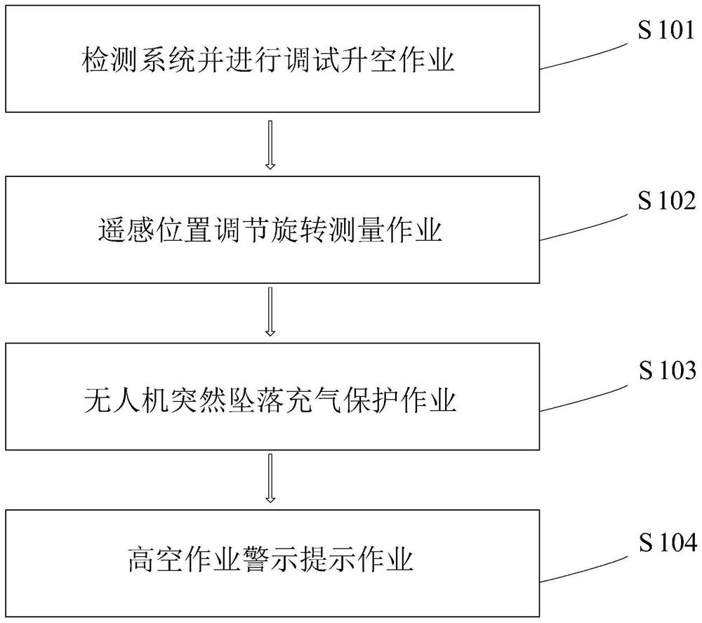
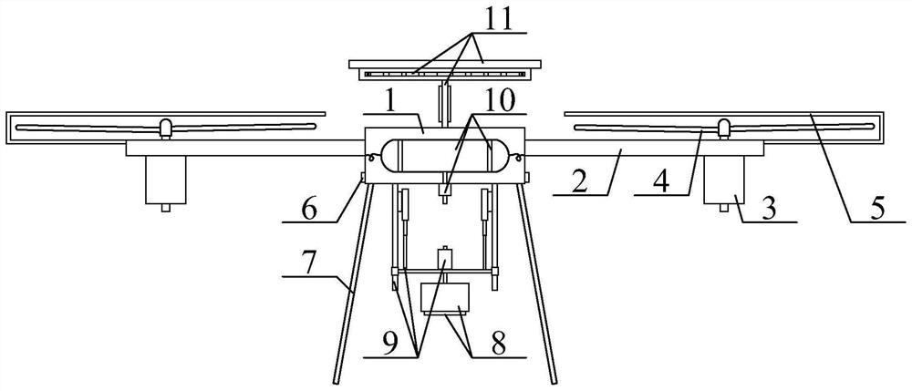
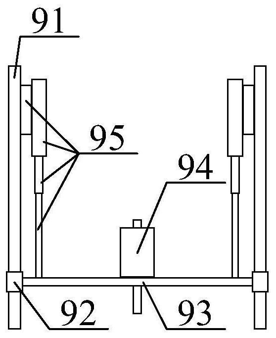
[0029] A multifunctional UAV remote sensing device for engineering survey, including UAV body 1, wing 2, motor 3, propeller 4, protective cover 5, speed sensor 6, support leg 7, remote sensor 8, rotary adjustable The remote sensing detection rod structure 9, the UAV fall protection airbag structure 10 and the high-altitude operation warning board structure 11, the upper and outer four corners of the UAV body 1 are bolted to the wing 2; the lower and outer sides of the wing 2 are bolted There is a motor 3; the upper end of the output shaft of the motor 3 is keyed to a propeller 4; the outer cover of the propeller 4 is connected with a protective cover 5; the protective cover 5 is connected to the outer end of the wing 2 by bolts; The outer four corners of the lower part of the drone body 1 a...


PUM


Abstract

The invention provides a multifunctional unmanned aerial vehicle remote sensing device for engineering surveying, which comprises an unmanned aerial vehicle body, wings, a motor, a propeller, a protective cover, a speed sensor, supporting legs, a remote sensor, a rotary adjustable remote sensing detection rod structure, an unmanned aerial vehicle falling protection airbag structure and a high-altitude operation warning board structure, wings are connected to four corners of the outer side of the upper part of the unmanned aerial vehicle body through bolts; the outer side of the lower part of the wing is in bolted connection with a motor; and the upper end of an output shaft of the motor is in key connection with the propeller. The linear sliding rail, the concentric-square-shaped sliding block, the lifting frame, the rotating motor and the telescopic push rod can be subjected to lifting adjustment, measurement operation can be conveniently carried out, requirements are met, rotating adjustment can be carried out, and the measurement effect is guaranteed; by means of the air bag, the reflective strip, the protective pull rope, the inflation pipe, the inflation pump and the air inlet pipe, emergency rapid inflation operation can be conducted, so that the unmanned aerial vehicle can safely land, and damage caused by sudden landing is avoided.

Description

technical field [0001] The invention belongs to the technical field of engineering survey, and in particular relates to a multifunctional remote sensing device for engineering survey and a method for using it. Background technique [0002] Engineering survey (engineering survey) refers to the general term for all surveying and mapping work in engineering construction, including various surveying work carried out in the stages of engineering construction survey, design, construction and management; in engineering survey, the most used surveying and mapping devices are fixed The fixed position of the frame is measured by the measuring instrument, and the precise measurement and mapping work can be carried out by cooperating with the scale structure. With the development of technology, there is also a certain demand for engineering measurement and mapping devices. [0003] At present, UAV remote sensing devices for engineering surveys are widely used in engineering surveys. ...

Claims


Application Information

Patent Timeline
Patent Type & Authority Applications(China)
IPC IPC(8): B64C39/02B64D45/00G01C11/02B64D47/02
CPCB64C39/024B64D45/00G01C11/02B64D47/02B64U30/20B64U50/19B64U2201/20
Inventor 詹景祥陈建东陈清平
Owner 广东省地质测绘研究院有限公司
Why Eureka
Try Eureka