Supercharge Your Innovation With Domain-Expert AI Agents!

Unmanned aerial vehicle pose parameter measurement system and method

A technology of pose parameters and measurement methods, which is applied in measurement devices, mapping and navigation, instruments, etc., can solve the problems of inaccurate pose parameters, measurement accuracy easily affected by image acquisition quality and image processing methods, etc.

Pending Publication Date: 2021-12-31
HUNAN UNIV
View PDF0 Cites 0 Cited by
  • Summary
  • Abstract
  • Description
  • Claims
  • Application Information

AI Technical Summary

Problems solved by technology

The machine vision method uses an indirect method to obtain the pose parameters of the UAV, and its measurement accuracy is easily affected by the quality of image acquisition and image processing methods, and the pose parameters obtained by measuring the UAV are not accurate

Method used


Image

  • Unmanned aerial vehicle pose parameter measurement system and method
  • Unmanned aerial vehicle pose parameter measurement system and method
  • Unmanned aerial vehicle pose parameter measurement system and method

Examples


Embodiment Construction

[0037] DETAILED DESCRIPTION OF THE PREFERRED EMBODIMENTS It should be understood that the specific embodiments described herein are intended to illustrate and explain the invention and are not intended to limit the invention.

[0038] In the description of the present invention, it should be noted that, unless otherwise expressly specified or limited, the terms "mounted," "Settings", "connected" are to be broadly understood, for example, the term "connector" may be a fixed connection, may be a detachable connection, or integrally connected; may be directly connected, or may be indirectly connected through intermediary, it may be interaction between the two internal communicating elements or two elements. The specific meaning of the above terms in the present invention can be understood in terms of specific cases.

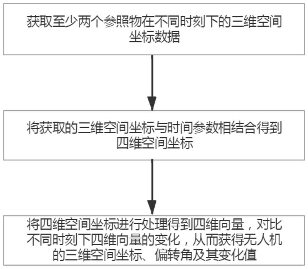
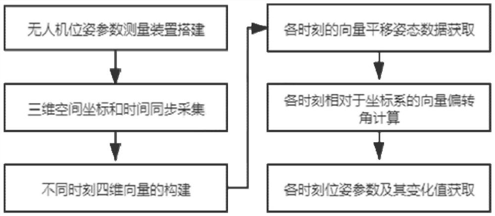
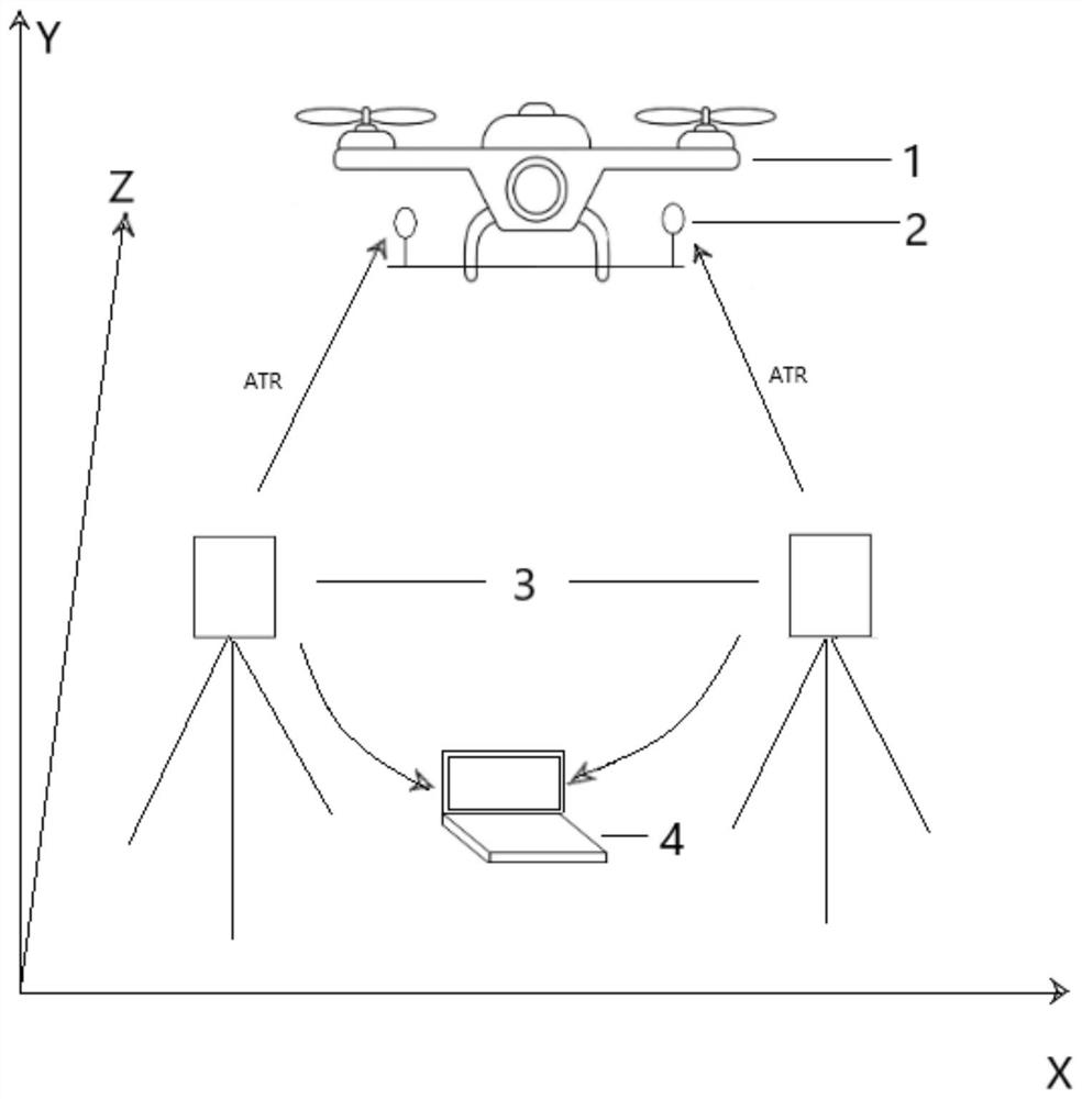
[0039] UAV embodiment of the method of the present invention pose parameter measurements, such as Figure 1 to 2 As shown, including the following steps:

[0040] 1) obt...


PUM


Abstract

The invention relates to the field of unmanned aerial vehicle measurement, and discloses an unmanned aerial vehicle pose parameter measurement method comprising the following steps: 1) obtaining three-dimensional space coordinate data of at least two reference objects at different moments; 2) combining the obtained three-dimensional space coordinate data information with the time data information corresponding to the three-dimensional space coordinate data information to obtain a four-dimensional space coordinate of the reference object; and 3) processing the four-dimensional space coordinates to obtain four-dimensional vectors at all moments, and comparing changes of the four-dimensional vectors at different moments to obtain three-dimensional space coordinates, vector deflection angles and change values of the unmanned aerial vehicle. Time parameters are introduced into three-dimensional space coordinates of at least two measurement reference objects obtained through measurement, so that the three-dimensional space coordinates are converted into four-dimensional space coordinates, and then the two four-dimensional space coordinates are connected to form a four-dimensional vector. Therefore, the pose parameter and the change value of the unmanned aerial vehicle corresponding to the measurement reference object can be visually reflected through the change of the four-dimensional vector.

Description

Technical field [0001] The present invention relates to the field of UAVs measurement, particularly, to systems and methods for measuring the pose parameters of the UAV. Background technique [0002] UAV tilt measurement technique is the use of unmanned aerial vehicles to carry PTZ camera to obtain the target area of ​​the image data, and a technique for reconstruction of three-dimensional model, the technology due to the high efficiency, low cost, accessibility and strong, low risk advantages, has been widely used in electrical inspection, river patrol, road patrol slope engineering, mine surveying and other areas, successful use of the technology to build a three-dimensional model can reflect on the whole area to be tested for relevant practitioners Status interpretation of the relevant area of ​​personnel. UAV itself pose parameters is crucial information, not only reflects the stability when hovering drones, and unmanned aerial vehicles directly determines the tilt photograph...

Claims


Application Information

Patent Timeline
Patent Type & Authority Applications(China)
IPC IPC(8): G01C21/00
CPCG01C21/00
Inventor 余加勇李若娴刘宝鳞
Owner HUNAN UNIV
Features
  • R&D
  • Intellectual Property
  • Life Sciences
  • Materials
  • Tech Scout
  • Unparalleled Data Quality
  • Higher Quality Content
  • 60% Fewer Hallucinations
Learn More