Geographic file data storage and read-write method

A technology of file data, reading and writing methods, applied in the field of data communication, can solve cumbersome problems, and achieve the effect of reducing operation procedures, low development and maintenance costs, and cost reduction

Active Publication Date: 2021-12-31
SHENZHEN URBAN TRANSPORT PLANNING CENT +1
View PDF4 Cites 1 Cited by
  • Summary
  • Abstract
  • Description
  • Claims
  • Application Information

AI Technical Summary

Problems solved by technology

However, whether it is the former or the latter, it can only be realized by relying on cumbersome dependency installation packages

Method used


Image

  • Geographic file data storage and read-write method
  • Geographic file data storage and read-write method
  • Geographic file data storage and read-write method

Examples


Embodiment Construction

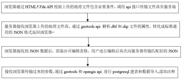
[0030] In order to make the object, technical solution and advantages of the present invention clearer, the present invention is described below through specific embodiments shown in the accompanying drawings. It should be understood, however, that these descriptions are exemplary only and are not intended to limit the scope of the present invention. Also, in the following description, descriptions of well-known structures and techniques are omitted to avoid unnecessarily obscuring the concept of the present invention.

[0031] In order to clarify the technical solution in this embodiment, in this embodiment, the explanation of each keyword that appears is as follows:

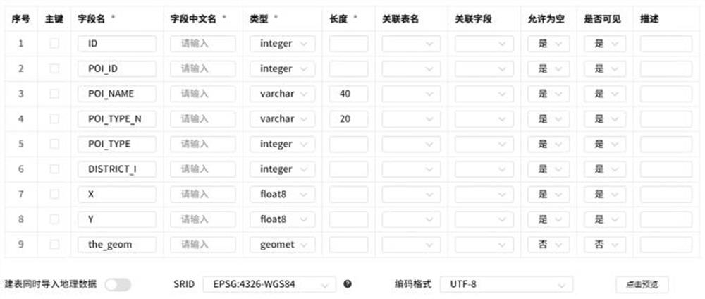
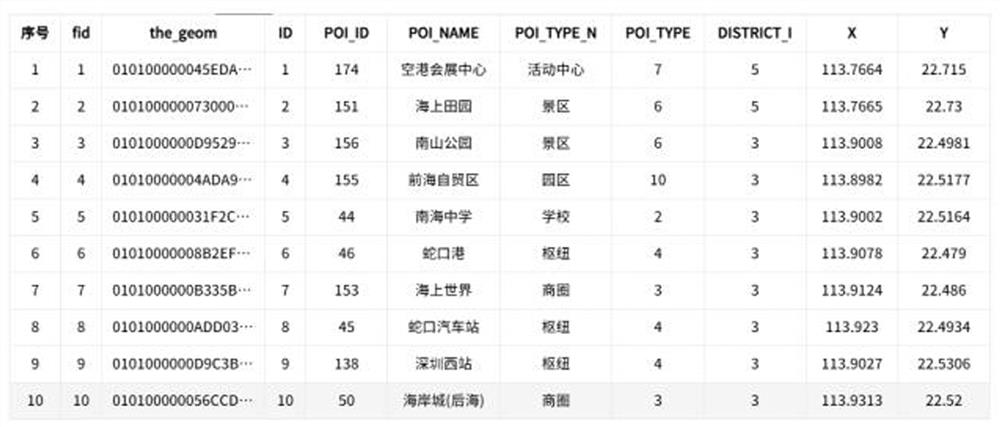
[0032] .shp — graphic format for saving geometric entities of elements;

[0033] .shx — Graphical index format. Geometry position index, which records the position of each geometry in the shp file, which can speed up the efficiency of forward or backward search for a geometry;

[0034] .dbf — attribute data ...


PUM


Abstract

The invention discloses a geographic file data storage and read-write method, and belongs to the technical field of data communication. The method comprises the steps that S100 a browser verifies an uploaded geographic data file through an HTML5 File API, and an http request interface is called to transmit a file stream to a server; S200 a server receives a geographic data file stream uploaded by the browser, analyzes attributes of. dbf and .shp files through geotools api, converts the geographic data file into a standard and universal JSON data format, and returns the geographic data file stream to the browser; S300 after the browser receives the JSON data, an editable table is rendered, and after the user edits the table, the matched JSON is transmitted to the server again; and S400 the server receives the parameters transmitted by the browser, postgresql table building and data importing are carried out through geotools and opengis api, and modification operation meeting parameter conditions is carried out on the attribute information of the table through jdbc api. According to the method, data processing can be realized without extra software support, and the operation process is reduced.

Description

technical field [0001] The invention relates to a method for storing geographic data files, which belongs to the technical field of data communication. Background technique [0002] Shapefile is an open format of spatial data. This file format is an open standard in the geographic information software industry. It can be read and written into the database by various geographic information processing software, such as Argis and QGIS. Shapefile is used to describe geometric objects: points, polylines, and polygons. These shapes and shape-related data attributes construct the representation of geographic data. For example, Shapefiles can store the geometric locations of spatial objects such as wells, rivers, and lakes. In addition to geometric locations, Shapefiles can also store attributes of these spatial objects, such as river names, city temperatures, and so on. Shapefile refers to a method of file storage. In fact, this file format is composed of multiple files. Among t...

Claims


Application Information

Patent Timeline
Patent Type & Authority Applications(China)
IPC IPC(8): G06F16/16G06F16/172G06F16/28G06F16/29
CPCG06F16/16G06F16/172G06F16/284G06F16/29Y02D10/00
Inventor 林涛朱华强任浩钟莉林青雅丘建栋庄立坚周子益刘星阚倩
Owner SHENZHEN URBAN TRANSPORT PLANNING CENT
Why Eureka
Try Eureka