
Video patrol method and system based on GIS space search and linear sorting

A spatial search and linear sorting technology, applied in database management systems, structured data retrieval, digital data information retrieval, etc., can solve problems such as inability to respond in time, inability to respond in time, message lag, etc.

Pending Publication Date: 2021-12-31
GUANGZHOU FRONTOP DIGITAL ORIGINALITY TECH CO LTD
View PDF0 Cites 0 Cited by
  • Summary
  • Abstract
  • Description
  • Claims
  • Application Information

AI Technical Summary

Problems solved by technology

[0007] (1) The method of full display will be limited by the number of monitors, network bandwidth and other hardware performance, and can only be realized in a very small range
In addition, patrol personnel cannot accurately pay attention to the situation in key areas, and cannot respond in a timely manner
[0008] (2) The method of artificially selecting relevant monitoring points will be affected by the familiarity of personnel with the business area, and the selected points are all out of order, and it is impossible to make orderly patrols according to the established route
[0009] (3) Both of the above two methods have the risk of message lag and the inability to plan and control in advance, and cannot respond in a timely manner to scenarios such as urban emergency and key personnel tracking

Method used


Image

  • Video patrol method and system based on GIS space search and linear sorting
  • Video patrol method and system based on GIS space search and linear sorting

Examples


specific Embodiment

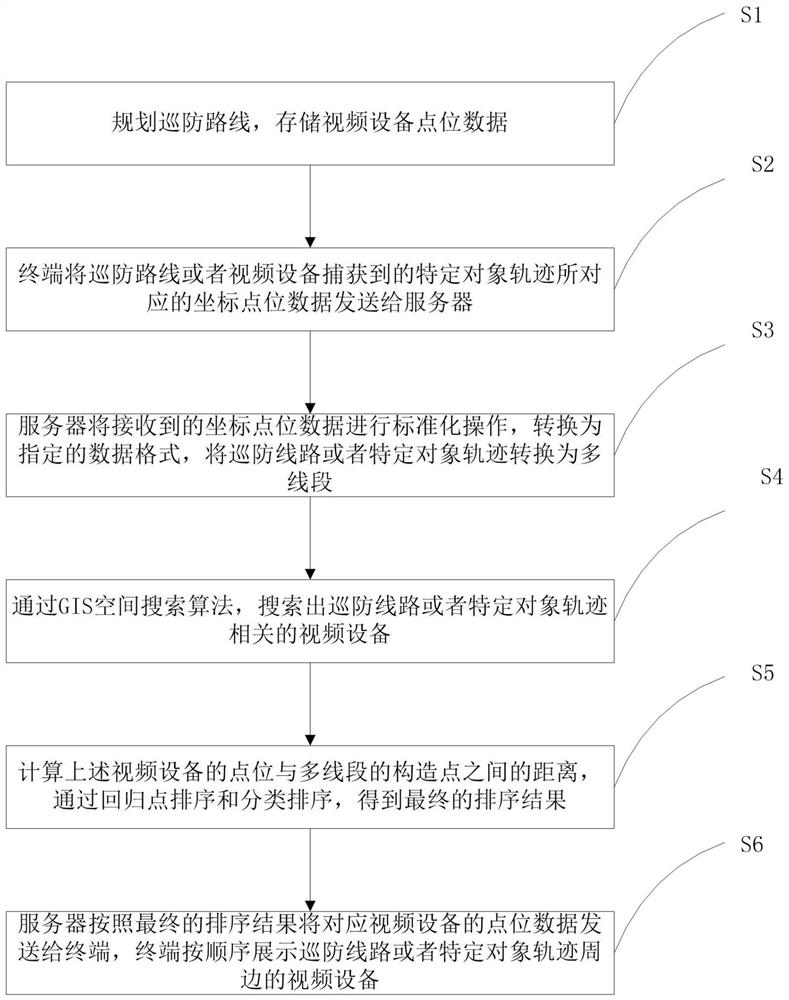
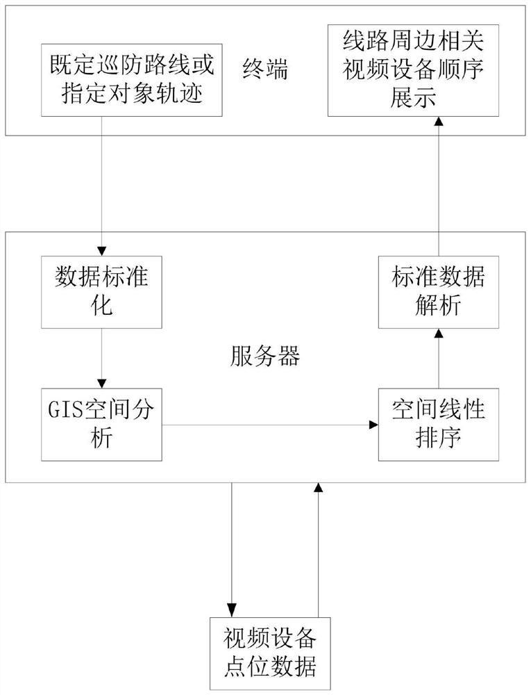
[0069] S1 and S2, the source of the route: the established patrol route planned by the client user, or the trajectory of key personnel captured by the acquisition device, contains a set of coordinate points composed of longitude and latitude information, and is determined based on the time stamp In sequence, these data are sent to the server in json format for processing.

[0070] S3, data standardization: After the server receives the data, it standardizes it through the open source SDK—GeoTools, and converts it into a specified Geometry format. This format supports various types of instantiation such as points, lines, polygons, multi-lines, and multi-surfaces. Tracks can be instantiated into commonly used Polylines.

[0071] S4, GIS spatial analysis: first add a buffer to the instantiated Polyline, because the commonly used latitude and longitude are geographic coordinates, and in practical applications, we usually search for peripheral devices with a radius of xx meters, wh...


PUM


Abstract

The invention provides a video patrol method and system based on GIS space search and linear sorting. A terminal sends a patrol route or coordinate point data corresponding to a specific object track to a server; the server converts the coordinate point data into a specified data format, and converts a patrol line or a specific object track into multiple line segments; video equipment related to a patrol line or a specific object track is searched through a GIS (Geographic Information System) space search algorithm; the distance is calculated between the point location of the video equipment and the construction points of the multiple line segments, and a final sorting result is acquired by regression point sorting and classification sorting; and the server sends the point location data to the terminal according to the final sorting result, and the terminal displays the peripheral video equipment in sequence. Related equipment point locations on a set route are accurately screened in a large range, so that patrol personnel can accurately pay attention to the condition of a key area and respond in time; and the sorted peripheral equipment can be obtained only by making a route plan, so that orderly patrol can be realized.

Description

technical field [0001] The invention relates to the technical field of video surveillance, in particular to a video surveillance method and system based on GIS space search and linear sorting. Background technique [0002] In recent years, with the maturity of Internet of Things technology, video surveillance has been widely used in the field of security. The rapid progress of security technology not only effectively supports the construction of "Safe City" and "Snow Bright Project", but also accelerates its integration into smart cities, becoming an important technical support for efficient urban management and serving the people's livelihood. And video surveillance has gradually become a very widely used patrol method at present. Combining with personnel patrol, it has played an important role in maintaining urban security. [0003] There are usually two types of existing video surveillance methods: [0004] 1. All video surveillance equipment is fully displayed, and pat...

Claims


Application Information

Patent Timeline
IPC IPC(8): G06F16/25G06F16/29G06F16/9537G06Q10/04G06Q50/26
CPCG06F16/29G06Q10/047G06Q50/26G06F16/9537G06F16/258
Inventor 谢君亮欧阳志远谢家豪
Owner GUANGZHOU FRONTOP DIGITAL ORIGINALITY TECH CO LTD
Learn More