Supercharge Your Innovation With Domain-Expert AI Agents!

Slope ground point cloud segmentation method and system based on multi-line laser radar

A multi-line laser and ground point technology, applied in the radio wave measurement system, image analysis, electromagnetic wave re-radiation, etc., can solve the problems of inability to meet the ground segmentation requirements of the three-dimensional complex slope environment, low ground segmentation accuracy, etc., to improve The effect of efficient, accurate and efficient segmentation

Active Publication Date: 2022-01-11
SHANDONG UNIV +1
View PDF8 Cites 2 Cited by
  • Summary
  • Abstract
  • Description
  • Claims
  • Application Information

AI Technical Summary

Problems solved by technology

[0005] The inventor found that since the ground is not perpendicular to the vertical direction of the radar in the real scene, there will be slopes or unevenness on the ground, the above three method systems may regard the slope as an obstacle, resulting in the accuracy of ground segmentation Low, unable to meet the ground segmentation requirements of the three-dimensional complex slope environment

Method used


Image

  • Slope ground point cloud segmentation method and system based on multi-line laser radar
  • Slope ground point cloud segmentation method and system based on multi-line laser radar
  • Slope ground point cloud segmentation method and system based on multi-line laser radar

Examples


Embodiment 1

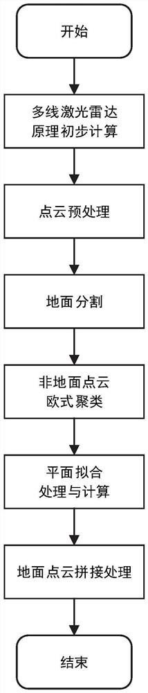
[0057] Such as figure 1 As shown, Embodiment 1 of the present invention provides a method for segmenting slope ground point clouds based on multi-line lidar, including the following process:

[0058] S1: Based on the principle of multi-line laser radar to obtain point cloud information, preprocess the original point cloud and segment reasonable areas.

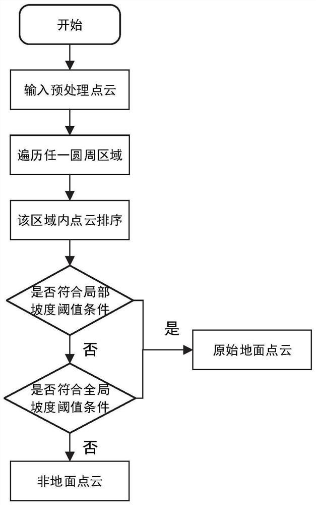
[0059] S2: Use the slope-based ground segmentation algorithm to segment the original point cloud into original ground points and non-ground points.

[0060] S3: Realize the European clustering of non-ground point clouds, and then carry out random sampling and consistent plane fitting for each category, and stitch the point clouds that meet the requirements with the original ground point clouds to realize the ground segmentation of slope scenes.

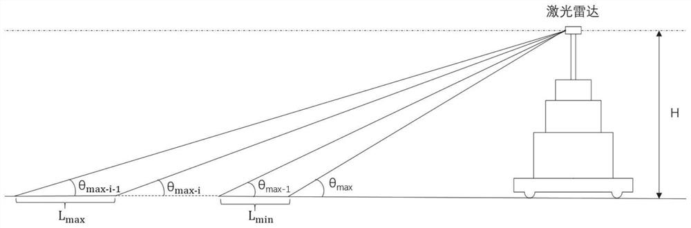
[0061] Specifically, in S1:

[0062] First, since the lidar has a maximum depression angle θ max , therefore, the minimum distance from the lidar to the ground:

[0063]

[0064...

Embodiment 2

[0085] Embodiment 2 of the present invention provides a slope ground point cloud segmentation system based on multi-line laser radar, including:

[0086] The data acquisition module is configured to: acquire the original point cloud data of the multi-line lidar;

[0087] The preprocessing module is configured to: preprocess the original point cloud data;

[0088] The point cloud segmentation module is configured to: perform preliminary ground segmentation processing on the preprocessed point cloud data to obtain non-ground point clouds;

[0089] The slope ground point cloud acquisition module is configured to perform European clustering on non-ground point clouds, perform random sampling consistent plane fitting for each category, and obtain slope ground point clouds based on the fitting results.

[0090] The working method of the system is the same as the multi-line lidar-based point cloud segmentation method for slope ground provided in Embodiment 1, and will not be repeate...

Embodiment 3

[0092] Embodiment 3 of the present invention provides a computer-readable storage medium on which a program is stored. When the program is executed by a processor, the method for segmenting slope ground point clouds based on multi-line laser radar as described in Embodiment 1 of the present invention is implemented. in the steps.


PUM


Abstract

The invention provides a slope ground point cloud segmentation method and system based on a multi-line laser radar, and belongs to the technical field of indoor and outdoor three-dimensional complex scene ground segmentation, and the method comprises the steps: obtaining original point cloud data of a multi-line laser radar; preprocessing the original point cloud data; performing preliminary ground segmentation processing on the preprocessed point cloud data to obtain a non-ground point cloud; carrying out european clustering on the non-ground point clouds, carrying out random sampling consistency plane fitting on each category, and obtaining slope ground point clouds through screening according to fitting results; and if a certain type of point cloud is judged to be slope ground point cloud, splicing the corresponding clustering fitting plane of the type with the original ground. According to the invention, the ground of the three-dimensional complex slope environment can be effectively identified and segmented, and the accuracy of slope ground segmentation is improved.

Description

technical field [0001] The invention relates to the technical field of ground segmentation of indoor and outdoor three-dimensional complex scenes, in particular to a method and system for point cloud segmentation of slope ground based on multi-line laser radar. Background technique [0002] The statements in this section merely provide background art related to the present invention and do not necessarily constitute prior art. [0003] With the rapid development of 5G technology and unmanned driving technology, 3D SLAM (Simultaneous Localization And Mapping) has gradually become a research hotspot in the field of outdoor complex environments. The difficulty of unmanned driving technology lies in accurate obstacle avoidance, and the key to accurate obstacle avoidance lies in ground segmentation and removal. Make sure all objects exist in isolation. [0004] Common laser point cloud ground segmentation methods are mainly divided into three categories. First, use the relative ...

Claims


Application Information

Patent Timeline
IPC IPC(8): G06T7/11G06T7/136G06V10/762G01S17/89
CPCG06T7/11G06T7/136G01S17/89G06T2207/10028G06T2207/20101G06F18/23
Inventor 皇攀凌李留昭周军赵一凡林乐彬欧金顺高新彪孟广辉付周
Owner SHANDONG UNIV
Features
  • R&D
  • Intellectual Property
  • Life Sciences
  • Materials
  • Tech Scout
  • Unparalleled Data Quality
  • Higher Quality Content
  • 60% Fewer Hallucinations
Learn More