
Flood disaster detection system based on unmanned aerial vehicle and Beidou positioning

A Beidou positioning and detection system technology, applied in satellite radio beacon positioning system, radio wave measurement system, radio transmission system, etc., can solve the problems of reducing the intelligence level of flood disaster detection, low measurement efficiency, and potential safety hazards

Active Publication Date: 2022-01-14
GUIZHOU EDUCATION UNIV
View PDF53 Cites 0 Cited by
  • Summary
  • Abstract
  • Description
  • Claims
  • Application Information

AI Technical Summary

Problems solved by technology

In order to monitor the water level before and after the flood, the water level height of the affected areas was measured one by one by manual survey in the past. This method not only needs a lot of manpower, material resources and time, but also has low measurement efficiency and great safety hazards. Hidden danger
In addition, the water level height data obtained through manual surveys needs to be manually entered and processed in order to truly reflect the water level at different locations in the disaster-stricken area, which seriously reduces the intelligence of flood disaster detection. It is also not conducive to timely and rapid rescue for areas with different water levels

Method used


Image

  • Flood disaster detection system based on unmanned aerial vehicle and Beidou positioning
  • Flood disaster detection system based on unmanned aerial vehicle and Beidou positioning
  • Flood disaster detection system based on unmanned aerial vehicle and Beidou positioning

Examples


Embodiment Construction

[0059] The following will clearly and completely describe the technical solutions in the embodiments of the present invention with reference to the accompanying drawings in the embodiments of the present invention. Obviously, the described embodiments are only some, not all, embodiments of the present invention. Based on the embodiments of the present invention, all other embodiments obtained by persons of ordinary skill in the art without creative efforts fall within the protection scope of the present invention.

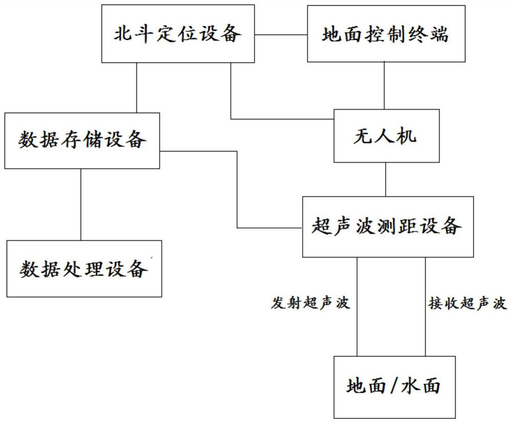
[0060] refer to figure 1 , is a schematic structural diagram of a flood disaster detection system based on UAV and Beidou positioning provided by an embodiment of the present invention. The flood disaster detection system based on UAV and Beidou positioning includes ground control terminal, UAV, Beidou positioning equipment, ultrasonic ranging equipment, data storage equipment and data processing equipment;

[0061] The ground control terminal is wirelessly connec...


PUM


Abstract

The invention provides a flood disaster detection system based on an unmanned aerial vehicle and Beidou positioning. According to the system, an unmanned aerial vehicle is used for carrying out flight patrol on a target area, and any place of the target area is positioned and ranged through Beidou positioning equipment and ultrasonic ranging equipment in the flight patrol process, so that RTK coordinate data of any place and height data between the unmanned aerial vehicle and the ground or the water surface are determined, and then water level height change contrast data of any place of the target area before and after the flood is generated, so that comprehensive water level monitoring and position calibration can be performed on the target area through the unmanned aerial vehicle to automatically obtain the sum of water level height data of different positions. Therefore, the detection comprehensiveness and intelligence of flood disaster situations are ensured, and the accuracy of water level height detection is improved.

Description

technical field [0001] The invention relates to the technical field of UAV monitoring, in particular to a flood disaster detection system based on UAV and Beidou positioning. Background technique [0002] As the global climate warms, the frequency of extreme weather such as torrential rains and typhoons increases, and floods occur frequently in roughly localized areas. In order to monitor the water level before and after the flood, in the past, the water level of the affected areas was measured one by one by manual survey. This method not only needs a lot of manpower, material resources and time, but also has low measurement efficiency and great safety hazards. Hidden danger. In addition, the water level height data obtained through manual surveys needs to be manually entered and processed to truly reflect the water level at different locations in the disaster-stricken area, which seriously reduces the intelligence of flood disaster detection. Also be unfavorable for carry...

Claims


Application Information

Patent Timeline
Patent Type & Authority Applications(China)
IPC IPC(8): G01S19/41G01S19/43G01S15/88G01S15/08G01F23/2962G08B21/10H04B7/185H04Q9/00
CPCG01S19/41G01S19/43G01S15/08G01S15/88G01F23/296G08B21/10H04B7/18506H04Q9/00H04Q2209/40Y02A50/00
Inventor 崔忠伟于国龙桑海伟王晴晴余飞张新左欣
Owner GUIZHOU EDUCATION UNIV
Learn More