Satellite image target intelligent recognition system and method based on improved ssd algorithm

A satellite image, intelligent recognition technology, applied in the field of computer vision, can solve the problems of large format, low resolution, poor recognition accuracy, etc., to achieve the effect of enhancing feature propagation, alleviating gradient disappearance, and accurate recognition

Active Publication Date: 2022-03-04
中国人民解放军96901部队
View PDF5 Cites 0 Cited by
  • Summary
  • Abstract
  • Description
  • Claims
  • Application Information

AI Technical Summary

Problems solved by technology

[0003] In practical applications, remote sensing images have the characteristics of large format and low resolution compared with conventional natural scene pictures. A series of intelligent recognition algorithms have poor recognition accuracy for typical small-scale targets

Method used


Image

  • Satellite image target intelligent recognition system and method based on improved ssd algorithm
  • Satellite image target intelligent recognition system and method based on improved ssd algorithm

Examples


Embodiment Construction

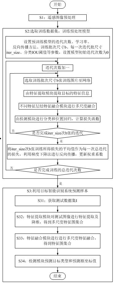
[0060] The technical solutions of the present invention will be further specifically described below in conjunction with the accompanying drawings and specific embodiments.

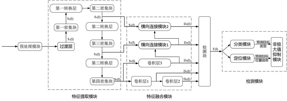
[0061] Such as figure 1 As shown, the satellite image target intelligent recognition system based on the improved SSD algorithm includes a sequentially connected preprocessing module, feature extraction module, feature fusion module and detection module;

[0062] The preprocessing module is used to cut the remote sensing image into sample images of consistent size;

[0063] The feature extraction module is used to receive the sample image, extract the features of the sample image, and form a multi-scale feature map set S(I); the feature extraction module adopts a dense convolutional neural network structure, including 1 transition layer, 4 dense blocks, from top to bottom The bottom is the first dense block, the second dense block, the third dense block, the fourth dense block module, and three conversio...


PUM


Abstract

The invention belongs to the technical field of computer vision, and in particular relates to a satellite image target intelligent recognition system and method based on an improved SSD algorithm. The satellite image target intelligent recognition system based on the improved SSD algorithm includes a preprocessing module, a feature extraction module, a feature fusion module and a detection module connected in sequence; the preprocessing module is used to cut the image into sample images of the same size; the feature extraction module uses It is used to receive sample images, extract features, and form a multi-scale feature map set; the feature fusion module is used to perform feature fusion of shallow feature maps and deep feature maps to construct a five-layer feature pyramid; the detection module is used to predict the category of the target and target prediction The coordinate value of the box. The present invention reduces the feature dimension by setting a transition layer, constructs a five-layer feature pyramid to realize multi-scale feature fusion, and adopts a combination of top-down and bottom-up feature extraction and fusion methods to realize accurate recognition of small targets in satellite images .

Description

technical field [0001] The invention belongs to the technical field of computer vision, and in particular relates to a satellite image target intelligent recognition system and method based on an improved SSD algorithm. Background technique [0002] With the rapid development of high-resolution satellites and the rapid increase of high-resolution remote sensing image data, research on remote sensing image target recognition algorithms under big data has become an urgent need. Compared with the traditional global and local feature extraction methods, deep learning, which has been developed in recent years, can extract features independently, and the extracted features have good adaptability, avoiding the complicated process of manual design and feature extraction. [0003] In practical applications, remote sensing images have the characteristics of large format and low resolution compared with conventional natural scene pictures. A series of intelligent recognition algorithm...

Claims


Application Information

Patent Timeline
Patent Type & Authority Patents(China)
IPC IPC(8): G06V20/13G06V10/80G06V10/764G06V10/77G06V10/82G06K9/62G06N3/04
CPCG06N3/045G06F18/213G06F18/241G06F18/253G06F18/214
Inventor 孟海东蒋鸣高润芳江光德许馨月姜伟魏建光吴克风
Owner 中国人民解放军96901部队
Why Eureka
Try Eureka