Control point online real-time rapid analysis method and device based on CORS network
A technology for rapid analysis and control points, applied in the field of satellite observation data processing, it can solve the problems of observation data analysis lag, etc., and achieve the effect of being conducive to fast fixation, improved accuracy, and fast solution.
- Summary
- Abstract
- Description
- Claims
- Application Information
AI Technical Summary
Problems solved by technology
Method used
Image

Examples
Embodiment 1
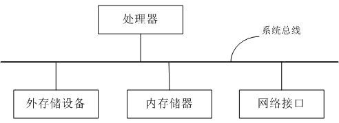
[0080] This embodiment proposes an online real-time rapid analysis method for control points based on the CORS network. This embodiment uses the prior data advantages of the existing CORS network solutions such as ambiguity and atmospheric errors to transmit the observation data of the control points to the data in real time. In the center, the control point and its nearby CORS stations are jointly networked and calculated to realize real-time online calculation and analysis of the observation data of the control point, which solves the shortcomings of traditional technology such as long time period, complicated workflow and high professional requirements. The hardware architecture that the method of this embodiment relies on is as follows: figure 1 As shown, the user only needs to set up an instrument on the control point to collect GNSS satellite observation data, and transmit the real-time observation data to the online calculation server through the network for data calcula...
Embodiment 2
[0149] This embodiment proposes an online real-time rapid analysis device for control points based on the CORS network, such as Figure 5 As shown, the device includes a task processing end, which includes a parameter analysis module, a data acquisition module, an initial coordinate calculation module, a network configuration generation module, an accurate calculation module, a network adjustment module, a verification module, and a result output module.
[0150]Among them, the parameter analysis module is used to analyze the solution-related parameter information (including data acquisition, accuracy requirements, acquisition frequency, instrument height, instrument model, contact information, etc.) obtained from the task establishment terminal.
[0151] The data acquisition module is used to obtain the satellite real-time observation data of the control point from the task establishment terminal according to the analyzed parameter information; the data acquisition module obt...
Embodiment 3
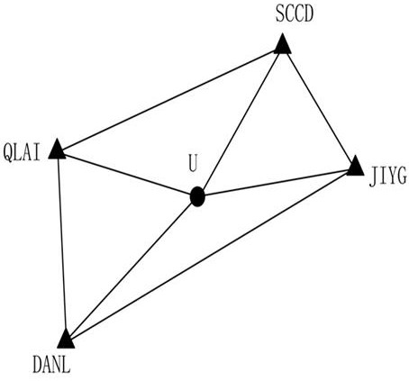
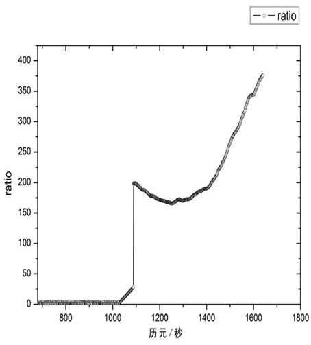
[0160] This embodiment adopts the XINJ reference station (denoted as U) in a CORS network as the control point to be solved, and uses the real-time satellite observation data (sampling interval of 1 second) of the control point to control the CORS network based on the above-mentioned embodiment 1. Point online real-time fast analysis method for verification, read and process one epoch data per second. The system processing flow is as follows:
[0161] (1) Perform initialization settings;
[0162] (2) Obtain parameter data and access the real-time satellite observation data stream of the point U to be calculated;
[0163] (3) Calculate the approximate position of U;
[0164] (4) Construct a virtual reference station at the approximate location of U, generate GGA with the approximate location, request differential data from the real-time positioning service of the CORS network, and use the received differential data as the observation data of the virtual reference station V; ...
PUM
 Abstract
Description
Claims
Application Information
PatSnap Eureka turns technology decisions into work you can execute. Powered by our Innovation Knowledge Graph, it runs expert workflows across engineering, life sciences, materials and intellectual property. Get your review-ready output in minutes.


