Supercharge Your Innovation With Domain-Expert AI Agents!

Roadside sensing fusion system based on vehicle-road cooperation and optimization method

A technology of vehicle-road coordination and optimization method, which can be applied to services, transmission systems, radio wave measurement systems and other directions based on specific environments.

Pending Publication Date: 2022-03-11
浙江海康智联科技有限公司
View PDF3 Cites 6 Cited by
  • Summary
  • Abstract
  • Description
  • Claims
  • Application Information

AI Technical Summary

Problems solved by technology

[0009] It can be seen that none of the existing technologies has solved the problem of sensory data accuracy error changes caused by the calibration of the roadside sensing equipment on the entire road section and the slight displacement of the sensor for a long time, resulting in the deviation of the sensory data provided to the surrounding road environment of the networked vehicle.

Method used


Image

  • Roadside sensing fusion system based on vehicle-road cooperation and optimization method
  • Roadside sensing fusion system based on vehicle-road cooperation and optimization method
  • Roadside sensing fusion system based on vehicle-road cooperation and optimization method

Examples


Embodiment Construction

[0030] Next, a specific embodiment of the present invention will be described in detail in conjunction with the accompanying drawings.

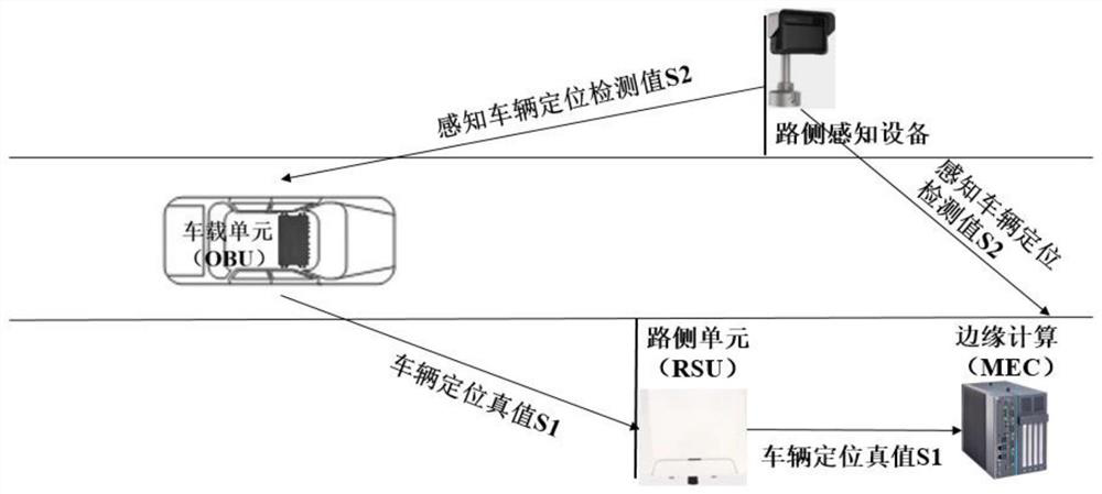
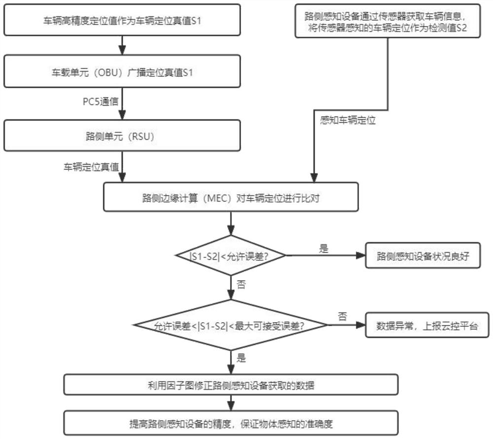
[0031] Reference attached figure 1 , a roadside perception fusion system based on vehicle-road coordination, including on-board unit (OBU), roadside unit (RSU), roadside edge computing (MEC), roadside perception equipment (radar, camera, etc.) and cloud control platform .

[0032] The on-board unit is installed inside the vehicle, and broadcasts the vehicle information (BSM message, including longitude and latitude position, speed, heading angle, braking, vehicle type, etc.) to the roadside unit through the vehicle-road coordination PC5 direct connection communication mode;

[0033] The roadside unit is arranged on the roadside of the road at a certain distance (generally 300-500 meters for urban roads), and is used to receive vehicle information broadcast by the vehicle unit and broadcast road and vehicle information to the outside world; ...


PUM


Abstract

The invention discloses an optimization method based on a roadside perception fusion system, and the method comprises the steps: taking vehicle-end positioning (vehicle-end high-precision GNSS, inertial navigation or high-precision map combined positioning) as a positioning truth value, and transmitting the positioning truth value to a roadside unit based on a vehicle-road cooperation mode; and determining the sensing accuracy of the roadside sensing equipment by comparing the vehicle positioning value acquired by the roadside sensing equipment with the positioning truth value fed back by the vehicle end based on the vehicle-road cooperation mode. When the difference value is within a certain range, all target positioning sensed by the roadside sensing equipment is corrected based on the vehicle end positioning data by using a factor graph positioning method, the accuracy of the road target data sensed by the roadside sensing equipment is improved, and correction information is also sent to the cloud platform through the roadside edge computing unit; and when the difference value exceeds a set error allowable range, a data abnormity early warning is reported to a platform end, so that monitoring of the roadside sensing data is realized. According to the invention, under the vehicle-road cooperation condition, the error of the data acquired by the roadside sensing device is corrected by using the factor graph method, so that the accuracy of the data acquired by the roadside sensing device is ensured.

Description

technical field [0001] The invention relates to the field of vehicle-road coordination roadside perception fusion, in particular to a roadside perception fusion system and optimization method based on vehicle-road coordination. Background technique [0002] Vehicle-road coordination technology refers to the use of advanced wireless communication and new-generation Internet technology to comprehensively implement vehicle-vehicle and vehicle-road dynamic real-time information interaction, and to carry out vehicle active safety control and road safety control on the basis of full-time and spatial dynamic traffic information collection and integration. Collaborative management fully realizes the effective coordination of people, vehicles and roads, ensures traffic safety, improves traffic efficiency, and forms a safe, efficient and environmentally friendly road traffic system. [0003] At present, the positioning accuracy requirements for self-driving vehicles are getting higher...

Claims


Application Information

Patent Timeline
IPC IPC(8): H04W4/44H04W4/06H04L67/025H04L67/12G08B21/18G01S13/86
CPCH04W4/44H04W4/06H04L67/025H04L67/12G08B21/18G01S13/86G01S13/867G01S13/865
Inventor 张莉邢珺李志伟沈志伟
Owner 浙江海康智联科技有限公司
Features
  • R&D
  • Intellectual Property
  • Life Sciences
  • Materials
  • Tech Scout
  • Unparalleled Data Quality
  • Higher Quality Content
  • 60% Fewer Hallucinations
Learn More