Multifunctional surveying and mapping unmanned aerial vehicle for surveying and mapping geographic information

A geographical and multi-functional technology for surveying and mapping, which is applied in the field of surveying and mapping UAVs to achieve the effect of accurate and convenient information collection

Active Publication Date: 2022-03-15
SHANDONG INST OF GEOPHYSICAL & GEOCHEM EXPLORATION
View PDF13 Cites 0 Cited by
  • Summary
  • Abstract
  • Description
  • Claims
  • Application Information

AI Technical Summary

Problems solved by technology

[0006] The purpose of the present invention is to provide a multifunctional surveying and mapping geographic information surveying and mapping UAV to solve the problems such as the defects of the prior art proposed in the above-mentioned background technology

Method used


Image

  • Multifunctional surveying and mapping unmanned aerial vehicle for surveying and mapping geographic information
  • Multifunctional surveying and mapping unmanned aerial vehicle for surveying and mapping geographic information
  • Multifunctional surveying and mapping unmanned aerial vehicle for surveying and mapping geographic information

Examples


Embodiment Construction

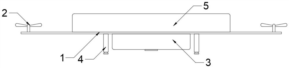
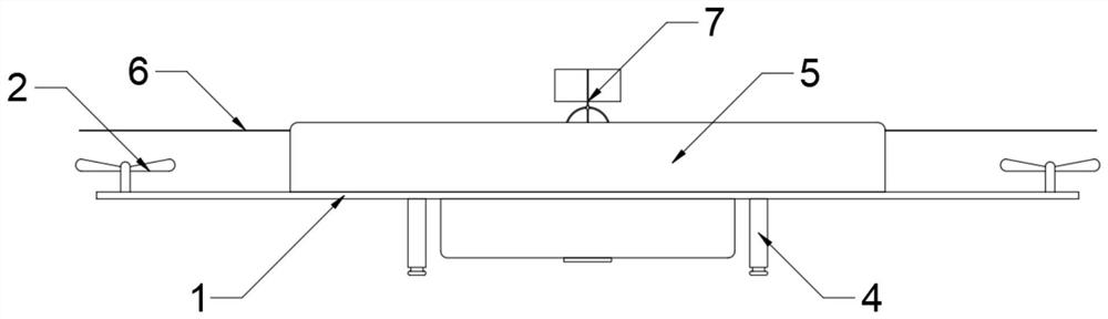
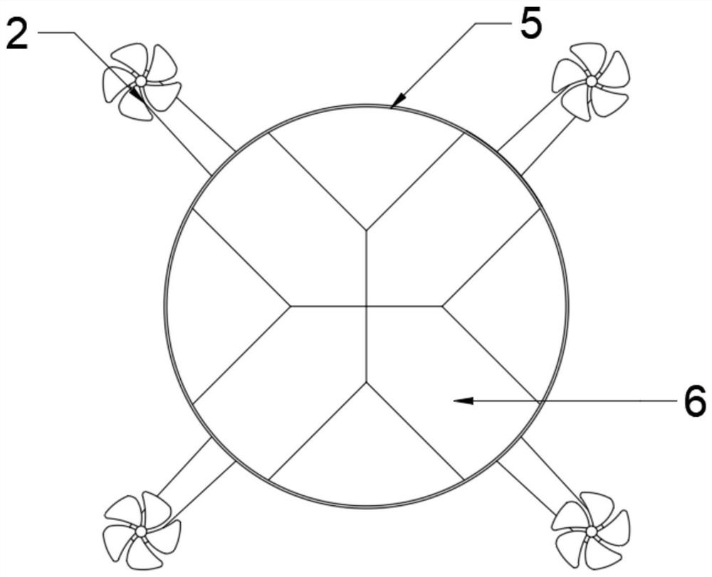
[0026] See Figure 1 ~ 5 In the embodiment of the present invention, a multifunctional mapping geographic information uses a mapping drone, including the rack 1 and the main body 3, the rack 1 to rotate the multi-set of wings that are connected to the main body 3. 2, the frame 1 is mounted on the mounting having a upper cover 5, and the upper cover 5 is slidably assembled with a plurality of groups 6 opposite to the wing 2, and the upper cover 5 is mounted to be provided with a driving cover plate. 6 Drive mechanism 8 in the direction of the chair wing 2, the drive mechanism 8 is fitted with a windder 7; when the drive mechanism 8 drives the cover 6 to the wing 2 to move close, the drive mechanism 8 Synchronously drives the wind speed. 7 moves in a direction away from the upper cover 5.

[0027] In this embodiment, preferably, the rack 1 and the main body 3 are commonly used in the prior art, assembled or integrated molding, and the main body 3 integrates the control circuit mother...


PUM


Abstract

The invention relates to the technical field of surveying and mapping unmanned aerial vehicles, and discloses a multifunctional surveying and mapping unmanned aerial vehicle for surveying and mapping geographic information. The multifunctional surveying and mapping unmanned aerial vehicle comprises a rack and a main machine body, and the rack is rotationally provided with multiple sets of wings in transmission connection with the main machine body; a plurality of groups of cover plates opposite to the wings are assembled on the upper cover in a sliding manner, a driving mechanism used for driving the cover plates to move relative to the wings is mounted in the upper cover, and an anemograph is assembled and connected on the driving mechanism; when the driving mechanism drives the cover plate to move towards the wings, the driving mechanism synchronously drives the anemograph to move in the direction away from the upper cover. Equipment for surveying and mapping can be effectively protected, the cover plate can be moved from the upper cover to the wing by starting the driving mechanism, the cover plate covers the wing, the driving mechanism can drive the anemograph to move upwards from the upper cover, the influence of the wing on information acquisition can be avoided by utilizing the cover plate, and the information acquisition is more accurate.

Description

Technical field [0001] The present invention relates to the field of surveying and mapping drones, and in particular, a multi-functional mapping geographic information is used to mapping drones. Background technique [0002] Drone is given more functions in the process of use, such as delivery drones, and drones who have a aerial photography and performances, but in the process of engineering measurement, the engineering measurement instrument is installed in On the human machine, and the drone can continuously fly to complete the buildings in the range and the corresponding scenarios and the corresponding three-dimensional modeling, and can make the people under three-dimensional construction Actual planning, although the precision is somewhat incomplete, but more than enough in planning stages. [0003] During the surveying process, not only collect the graphics information, but also information on the wind speed can affect the construction. [0004] An inclined photographic me...

Claims


Application Information

Patent Timeline
Patent Type & Authority Applications(China)
IPC IPC(8): B64C39/02B64D47/00B64C25/64
CPCB64C39/02B64D47/00B64C25/64B64U30/20B64U2101/30B64U2101/00
Inventor 王岳王爱华高宏涛
Owner SHANDONG INST OF GEOPHYSICAL & GEOCHEM EXPLORATION
Why Eureka
Try Eureka