Remote sensing satellite stereoscopic image elevation precision quantitative evaluation method

A technology of stereoscopic imaging and quantitative evaluation, applied in photogrammetry/video surveying, measuring devices, instruments, etc., to achieve the effect of simple operation, scientific evaluation results, and great practical advantages

Pending Publication Date: 2022-03-15
自然资源部国土卫星遥感应用中心
View PDF0 Cites 0 Cited by
  • Summary
  • Abstract
  • Description
  • Claims
  • Application Information

AI Technical Summary

Problems solved by technology

[0007] S1 Quantitative evaluation of satellite stereo image elevation positioning error Δ

Method used


Image

  • Remote sensing satellite stereoscopic image elevation precision quantitative evaluation method
  • Remote sensing satellite stereoscopic image elevation precision quantitative evaluation method
  • Remote sensing satellite stereoscopic image elevation precision quantitative evaluation method

Examples


Embodiment Construction

[0019] In order to make the object, technical solution and advantages of the present invention clearer, the present invention will be further described in detail below in conjunction with the embodiments and accompanying drawings.

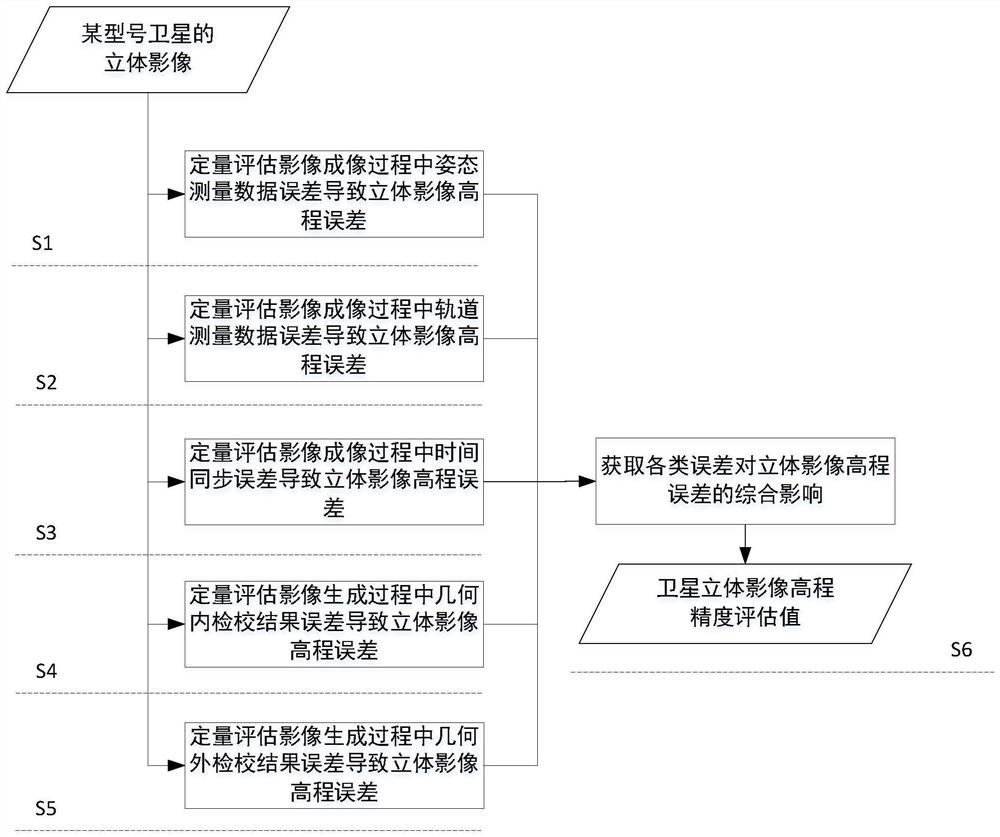
[0020] like figure 1 As shown, it is the process flow of the quantitative evaluation method for the elevation accuracy of the remote sensing satellite stereoscopic image, including the following steps:

[0021] Step S1 Quantitatively evaluate the satellite stereo image elevation positioning error Δh caused by the attitude measurement data error in the satellite image imaging process attitude , this step specifically includes the following content,

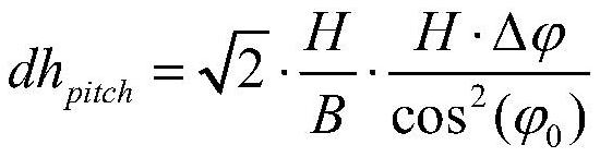
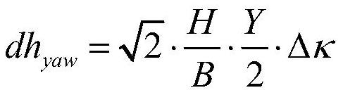
[0022] Step S11, according to the influence principle of the attitude and pitch angle error on the stereo image elevation error in the satellite image imaging process, define and evaluate the stereo image elevation error dh caused by the attitude and pitch angle error pitch method, the formula is,

...


PUM


Abstract

The invention discloses a remote sensing satellite stereoscopic image elevation precision quantitative evaluation method. The method comprises the following steps: quantitatively evaluating a satellite stereoscopic image elevation positioning error caused by an attitude measurement data error in a satellite image imaging process; a satellite stereo image elevation positioning error caused by an orbit measurement data error in a satellite image imaging process is quantitatively evaluated; a satellite stereo image elevation positioning error caused by a time synchronization error in a satellite image imaging process is quantitatively evaluated; a satellite stereo image elevation positioning error caused by a geometric internal calibration result error in a satellite image processing process is quantitatively evaluated; a satellite stereo image elevation positioning error caused by a geometric external calibration result error in a satellite image processing process is quantitatively evaluated; and comprehensively evaluating the overall influence of various errors on the elevation accuracy of the stereoscopic image in the satellite image imaging process and the satellite image processing process, and obtaining the final elevation positioning error of the satellite stereoscopic image, namely the quantitative evaluation result of the elevation accuracy of the satellite stereoscopic image.

Description

technical field [0001] The invention relates to the technical field of photogrammetry, in particular to a method for quantitatively evaluating elevation accuracy of remote sensing satellite stereo images. Background technique [0002] The geometric accuracy of satellite images includes plane accuracy and elevation accuracy, which are the most critical indicators to determine the quality of satellite images and their mapping application capabilities. Carrying out theoretical analysis and quantitative evaluation of the elevation accuracy of satellite stereoscopic images is not only the basic guarantee work for the application of satellite images, but also can provide a reference for the design and formulation of technical indicators in the development process of remote sensing satellites. At present, domestic and foreign scholars' evaluation of the geometric accuracy of high-resolution remote sensing satellite images is mainly focused on selecting typical test areas and using ...

Claims


Application Information

Patent Timeline
IPC IPC(8): G01C11/00G01C25/00
CPCG01C11/00G01C25/00
Inventor 周平莫凡谢俊峰唐新明傅征博郭莉陈颖王霞
Owner 自然资源部国土卫星遥感应用中心
Why Eureka
Try Eureka