Multi-precision DEM data difference smooth fusion method and system

A fusion method and multi-precision technology, applied in image data processing, 3D modeling, instruments, etc., can solve the problems of low authenticity and accuracy of DEM data imaging, achieve control and reduce the selection range, reduce data flow, improve The effect of efficiency and precision

Active Publication Date: 2022-03-25
BEIJING GUOWANG FUDA SCI & TECH DEV
View PDF9 Cites 2 Cited by
  • Summary
  • Abstract
  • Description
  • Claims
  • Application Information

AI Technical Summary

Problems solved by technology

[0003] The present invention provides a multi-precision DEM data difference smooth fusion method and system to solve the problem of low authenticity and accuracy of DEM data imaging in existing substations and cable tunnel scenarios:

Method used


Image

  • Multi-precision DEM data difference smooth fusion method and system
  • Multi-precision DEM data difference smooth fusion method and system
  • Multi-precision DEM data difference smooth fusion method and system

Examples


Embodiment Construction

[0063] The preferred embodiments of the present invention will be described below in conjunction with the accompanying drawings. It should be understood that the preferred embodiments described here are only used to illustrate and explain the present invention, and are not intended to limit the present invention.

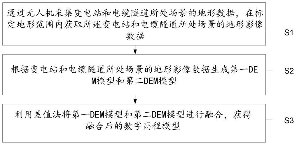
[0064] The present invention proposes a multi-precision DEM data difference smooth fusion method, such as figure 1 As shown, the method includes:

[0065] S1. Collect the terrain data of the scene where the substation and the cable tunnel are located through the drone, and obtain the terrain image data of the scene where the substation and the cable tunnel are located within the scope of the calibrated terrain;

[0066] S2. Generate a first DEM model and a second DEM model according to the terrain image data of the scene where the substation and the cable tunnel are located;

[0067] S3. Using the difference method to fuse the first DEM model and the second DEM mod...


PUM


Abstract

The invention provides a multi-precision DEM (Digital Elevation Model) data difference smooth fusion method and system. The method comprises the steps of collecting topographic data of a scene where a transformer substation and a cable tunnel are located through an unmanned aerial vehicle, and obtaining topographic image data of the scene where the transformer substation and the cable tunnel are located within a calibrated topographic range; generating a first DEM model and a second DEM model according to the topographic image data of the scene where the transformer substation and the cable tunnel are located; and fusing the first DEM model and the second DEM model by using a difference method to obtain a fused digital elevation model. The system comprises modules corresponding to the steps of the method.

Description

technical field [0001] The invention discloses a multi-precision DEM data difference smoothing fusion method and system, belonging to the technical field of three-dimensional imaging. Background technique [0002] Data fusion generally refers to the combination, correlation and combination of data and information from multiple sensor information sources to obtain more accurate observation information to support the required decision-making and evaluation tasks; DEM fusion is to overcome the problem by mining complementary information between data. Deficiencies in data quality, improve data accuracy. However, when the existing DEM fusion technology builds a 3D model for the environment of the substation and cable tunnel scene, there are problems of low authenticity and low accuracy. Contents of the invention [0003] The present invention provides a multi-precision DEM data difference smooth fusion method and system to solve the problem of low authenticity and accuracy of ...

Claims


Application Information

Patent Timeline
Patent Type & Authority Applications(China)
IPC IPC(8): G06T17/05
CPCG06T17/05
Inventor 吴琼高方玉刘铭倪康婷陈春梅张彦峰王茹董孟军王韦莹孙永锋王兴勋
Owner BEIJING GUOWANG FUDA SCI & TECH DEV
Why Eureka
Try Eureka