
Space matching method and system for urban road and bus route

A technology for bus lines and roads, applied in structured data retrieval, instruments, geographic information databases, etc., can solve problems such as low matching efficiency, high computing power requirements, and poor matching accuracy

Pending Publication Date: 2022-03-29
北京交通发展研究院
View PDF0 Cites 0 Cited by
  • Summary
  • Abstract
  • Description
  • Claims
  • Application Information

AI Technical Summary

Problems solved by technology

[0005] The purpose of this application is to provide a method and system for spatial matching of urban roads and bus lines to solve the problem of poor matching accuracy based on intersection nodes when matching bus lines and urban roads in the prior art, making it difficult to adapt to complex refinements The road network problem, in addition, when using the minimum sum of the area of ​​the closed polygon enclosed by the bus line and the urban road for matching, there is a technical problem that requires high computing power, resulting in low matching efficiency

Method used


Image

  • Space matching method and system for urban road and bus route
  • Space matching method and system for urban road and bus route
  • Space matching method and system for urban road and bus route

Examples


Embodiment 1

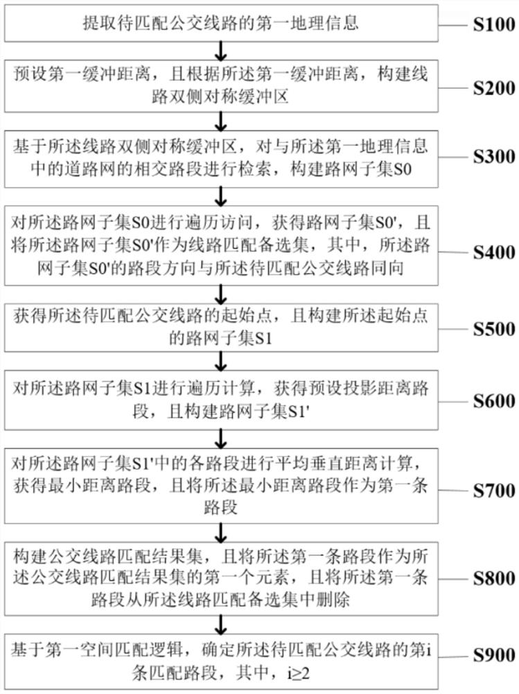
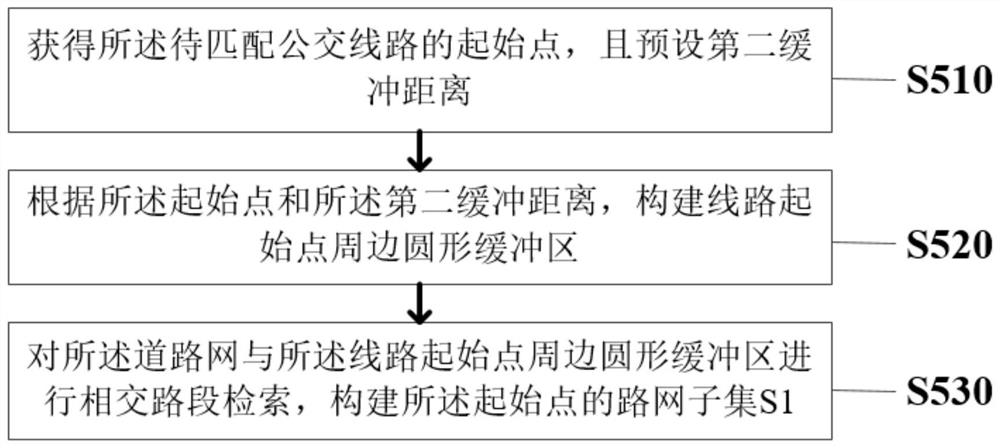
[0031] Please refer to the attached figure 1 , the embodiment of the present application provides a method for spatial matching of urban roads and bus routes, wherein the method is applied to a spatial matching system of urban roads and bus routes, and the method specifically includes the following steps:

[0032] Step S100: extracting the first geographic information of the bus line to be matched;

[0033] Specifically, the method for spatial matching of urban roads and bus lines is applied to the spatial matching system of urban roads and bus lines. By constructing a line matching candidate set based on a large-scale road network, the line In the matching candidate set, each road section of the bus line is matched sequentially in the form of moving steps, and the "average distance of five equal points" is used as the optimization strategy, which reduces the amount of calculation, improves the noise resistance of the matching method, and achieves In order to improve the nois...

Embodiment 2

[0088] Based on the same inventive concept as the method for spatial matching of urban roads and bus lines in the foregoing embodiments, the present invention also provides a spatial matching system for urban roads and bus lines, please refer to the attached image 3 , the system includes:

[0089] The first extraction unit 11: the first extraction unit 11 is used to extract the first geographical information of the bus line to be matched;

[0090] The first construction unit 12: the first construction unit 12 is used to preset a first buffer distance, and according to the first buffer distance, construct a symmetrical buffer zone on both sides of the line;

[0091] The second construction unit 13: the second construction unit 13 is used to retrieve the intersecting road sections with the road network in the first geographical information based on the symmetrical buffer zone on both sides of the line, and construct the road network subset S 0 ;

[0092] The first obtaining u...


PUM


Abstract

The invention discloses a spatial matching method and system for an urban road and a bus route. The method comprises the following steps: extracting first geographic information of a to-be-matched bus route; a first buffer distance is preset, and symmetrical buffer areas on the two sides of the line are constructed; constructing a road network subset S0; obtaining a road network subset S0 ', and setting the road network subset S0' as a line matching alternative set; obtaining a starting point, and constructing a road network subset S1; obtaining a preset projection distance road section, and constructing a road network subset S1 '; obtaining a minimum distance road section as a first road section; constructing a bus route matching result set; and determining the i-th matched road section of the bus route to be matched based on the first space matching logic. The problems that when a bus route is matched with an urban road in the prior art, the matching precision based on intersection nodes is poor, and a complex and refined road network is difficult to adapt are solved, and in addition, the technical problem that when the sum of the areas of closed polygons defined by the bus route and the urban road is minimum for matching, the computing power requirement is high, and the matching efficiency is low is solved.

Description

technical field [0001] The present application relates to the field of computer application technology, in particular to a method and system for spatial matching of urban roads and bus routes. Background technique [0002] In the field of urban transportation, it is of great significance for traffic operation monitoring, evaluation, and related research work to master the operation indicators of bus traffic speed and bus cross-section passenger flow in each section of urban roads. However, indicators such as bus operating speed and bus passenger flow are usually measured in units of bus lines. The bus line network and urban road network exist independently in layers, so the calculated bus line indicators cannot directly correspond to urban road sections. Therefore, it is necessary to establish a spatial matching relationship between bus lines and urban roads. Due to surveying and mapping errors and mapping deviations, the actually collected bus route electronic map trajecto...

Claims


Application Information

Patent Timeline
Patent Type & Authority Applications(China)
IPC IPC(8): G06F16/29G06Q50/26
CPCG06F16/29G06Q50/26
Inventor 朱珊孙建平温慧敏张溪徐德中赵祥雷方舒徐春玲
Owner 北京交通发展研究院
Learn More