Eureka AIR delivers breakthrough ideas for toughest innovation challenges, trusted by R&D personnel around the world.

Collaborative perception positioning method and system

A technology of collaborative perception and positioning method, applied in the field of positioning, can solve the problems of large impact, limited installation cost of positioning system, low positioning accuracy, etc., and achieve the effect of high real-time performance, dynamic adjustment of real-time performance, and accurate positioning

Pending Publication Date: 2022-04-08
WUHAN YIXUN ELECTRONICS INFORMATION TECH
View PDF10 Cites 3 Cited by
  • Summary
  • Abstract
  • Description
  • Claims
  • Application Information

AI Technical Summary

Problems solved by technology

[0010] The present invention provides a collaborative sensing positioning method and system to solve the defects in the prior art that the comprehensive positioning of urban roads is greatly affected by the road environment, limited by the installation cost of the existing positioning system, and the positioning accuracy is not high

Method used


Image

  • Collaborative perception positioning method and system
  • Collaborative perception positioning method and system
  • Collaborative perception positioning method and system

Examples


Embodiment Construction

[0048] In order to make the purpose, technical solutions and advantages of the present invention clearer, the technical solutions in the present invention will be clearly and completely described below in conjunction with the accompanying drawings in the present invention. Obviously, the described embodiments are part of the embodiments of the present invention , but not all examples. Based on the embodiments of the present invention, all other embodiments obtained by persons of ordinary skill in the art without creative efforts fall within the protection scope of the present invention.

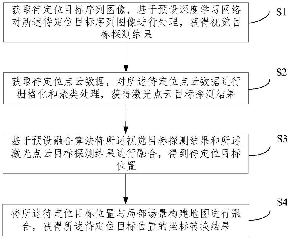
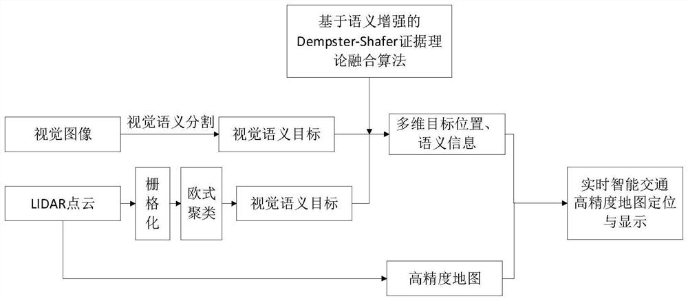
[0049] Aiming at the many defects in road positioning in the current city, the present invention proposes a collaborative sensing positioning method based on drive test equipment, the purpose of which is to establish a high-precision map in the drive test scene, and in this scene, complete the real-time traffic elements ( Including the location information of people, vehicles and objects, etc...


PUM


Abstract

The invention provides a collaborative perception positioning method and system, and the method comprises the steps: obtaining a to-be-positioned target sequence image, processing the to-be-positioned target sequence image based on a preset deep learning network, and obtaining a visual target detection result; obtaining to-be-positioned point cloud data, and performing rasterization and clustering processing on the to-be-positioned point cloud data to obtain a laser point cloud target detection result; fusing the visual target detection result and the visual target detection result based on a preset fusion algorithm to obtain a to-be-positioned target position; and fusing the position of the to-be-positioned target with a local scene construction map to obtain a coordinate conversion result of the position of the to-be-positioned target. According to the invention, a plurality of road test devices are arranged to carry out cooperative sensing positioning on the to-be-positioned target, vehicle positioning and positioning of other elements on the road are considered at the same time, and the method has the characteristics of accurate positioning, high real-time performance and dynamic adjustment.

Description

technical field [0001] The present invention relates to the technical field of positioning, in particular to a method and system for cooperative sensing positioning. Background technique [0002] With the acceleration of the urbanization process, more and more large-scale cities are being built, and the roads inside the large-scale cities are becoming more and more complicated, and the safety requirements for roads and driving are also getting higher and higher. [0003] At present, many cities have accelerated the construction of smart transportation, the core of which is vehicle-road coordination, which mainly realizes the effective coordination of people, vehicles and roads to ensure traffic safety and improve traffic efficiency. In traditional road traffic scenarios, high-precision maps are mostly used to collect vehicle information, and comprehensive road information is collected in advance. Correspondingly, vehicles are equipped with sensors such as satellite receivers...

Claims


Application Information

Patent Timeline
Patent Type & Authority Applications(China)
IPC IPC(8): G01C21/28G01C21/32G01S17/06G01S17/50G06K9/62
Inventor 陈志涛付诚夏华佳徐天澈郭凯吴鹏刘林谢超
Owner WUHAN YIXUN ELECTRONICS INFORMATION TECH
Why Eureka
Eureka Blog
Learn More