Underwater air imaging full-link simulation method

A simulation method and a full-link technology, applied in the field of underwater air-to-air imaging, can solve problems such as inability to directly reflect the status, long prototype development cycle, insufficient verification of imaging technology and image processing algorithms, etc.

Pending Publication Date: 2022-04-15
武汉华中天纬测控有限公司
View PDF0 Cites 2 Cited by
  • Summary
  • Abstract
  • Description
  • Claims
  • Application Information

AI Technical Summary

Problems solved by technology

[0003] The manufacturing cost of the underwater air-to-air imaging experimental prototype is high, the development cycle of the prototype is long, and the new imaging technology and image processing algorithm are not fully verified before being applied to the prototype
The current public tests and test methods are often carried out on water tanks, boat ponds and inland lakes, and cannot directly reflect the state of the real environment at sea

Method used


Image

  • Underwater air imaging full-link simulation method
  • Underwater air imaging full-link simulation method
  • Underwater air imaging full-link simulation method

Examples


Embodiment Construction

[0062] The present invention will be further described below in conjunction with the accompanying drawings and specific embodiments.

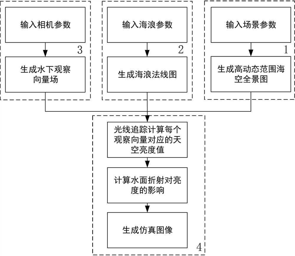
[0063] The invention discloses a full-link simulation method for underwater air-to-air imaging, which is helpful for the research and development of underwater air-to-air imaging systems.

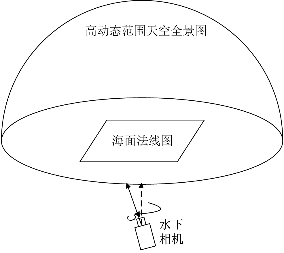
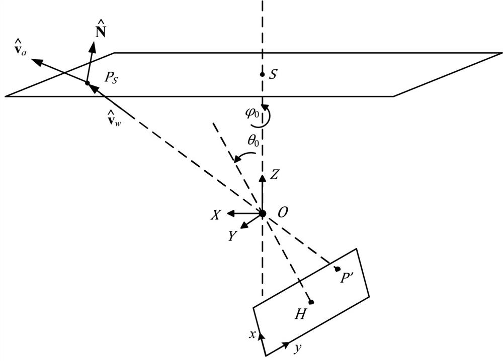
[0064] The present invention first establishes four coordinate systems in the underwater air-to-air imaging link: a three-dimensional Cartesian coordinate system is established with the optical center of the underwater optical system as the origin as coordinate system 1, and the image coordinate system of the underwater camera is used as coordinate system 2. Establish a two-dimensional sea-level coordinate system on the sea level with the origin directly above the optical center as the coordinate system 3, and establish a hemispherical space horizon coordinate system (or zenith angle-azimuth angle) on the sea surface with the origin directly above the optical...


PUM


Abstract

The invention discloses an underwater air imaging full-link simulation method, which is based on a simulation module system formed by a scene simulation module, a sea wave simulation module, a camera simulation module and a light ray tracing module, and is characterized in that the scene simulation module generates a high-dynamic range sea-air panorama according to input scene parameters; the sea wave simulation module generates a sea wave normal diagram according to input sea wave parameters, the camera simulation module generates an underwater observation vector field according to input camera parameters, and the light ray tracing module firstly calculates a sky brightness value corresponding to each observation vector through light ray tracing according to input of the scene simulation module, the sea wave simulation module and the camera simulation module; then calculating the influence of water surface refraction on the brightness, and finally generating a simulation graph; according to the simulation method, underwater air imaging modeling and water surface target intelligent detection under random sea wave disturbance can be realized.

Description

technical field [0001] The invention belongs to the technical field of underwater air-to-air imaging, and in particular relates to a full-link simulation method of underwater air-to-air imaging. By modeling an underwater air-to-air imaging system, the simulation of underwater air-to-air imaging effects is realized. Background technique [0002] Underwater air-to-air imaging uses underwater cameras to perform cross-media imaging detection of air and water surface targets. The imaging system designed for this imaging method needs to regard the water body between the camera and the target as a part of the optical system. The impact of random sea waves on imaging is huge and uncontrollable, which brings challenges to the design of underwater air-to-air imaging system and its image processing algorithm. great difficulty. For this reason, it is necessary to do simulation research before designing the underwater air-to-air imaging system. [0003] The manufacturing cost of the un...

Claims


Application Information

Patent Timeline
Patent Type & Authority Applications(China)
IPC IPC(8): G06F30/20
Inventor 张瑞文李阳阳许东阳李忠
Owner 武汉华中天纬测控有限公司
Why Eureka
Try Eureka