Dynamic 3D city model construction method for city canyon environment navigation

A city model and urban canyon technology, applied in the field of satellite positioning and navigation, can solve problems such as error, rough database, lack of information update, etc.

Pending Publication Date: 2022-04-15
浙江建德通用航空研究院 +2
View PDF0 Cites 5 Cited by
  • Summary
  • Abstract
  • Description
  • Claims
  • Application Information

AI Technical Summary

Problems solved by technology

Most of the existing databases for 3D city models are relatively rough, and many details of buildings and roads are not involved, which is easy to cause misjudgment of NLOS signals or additional errors when performing pseudorange correction
A small number of 3D city models are purchased by researchers from professional surveying and mapping companies. Although this kind of 3D city model has better accuracy, the overall cost is relatively high
In addition, the above-mentioned 3D city model also has a shortcoming, that is, the hysteresis of its information
Some models were built some time ago, and the same model may have been used for several years, but the city is in a process of constant change, so it lacks timely and accurate information updates

Method used


Image

  • Dynamic 3D city model construction method for city canyon environment navigation
  • Dynamic 3D city model construction method for city canyon environment navigation
  • Dynamic 3D city model construction method for city canyon environment navigation

Examples


Embodiment Construction

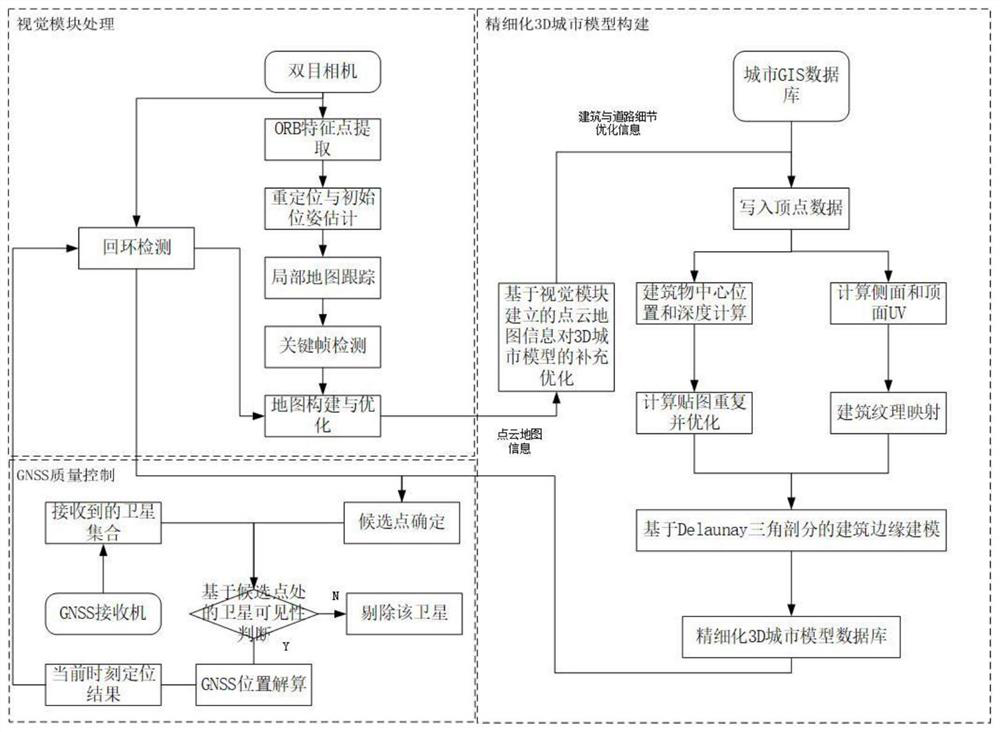
[0067] A flow chart of a method for constructing a dynamic 3D city model for urban canyon environment navigation figure 1 As shown, it includes the following two stages. 1. Construction of static and refined 3D city model and 2. Dynamic optimization of 3D city model based on location information generated by vision / GNSS / 3D model fusion

[0068] 1. Static and refined 3D city model construction

[0069] First, the data information related to buildings and roads is obtained from the initial urban building road database, including: building boundary corner information, road boundary corner information, texture information, building and road identification information, and written into the building and road information. Vertex information. Calculate the center coordinates of the building based on the existing corner points and side length information of the building. The 3D model of the building is established by using the center point of the building to determine the position a...


PUM


Abstract

The invention discloses a dynamic 3D city model construction method for city canyon environment navigation. The method comprises two steps of static refined 3D city model construction and dynamic optimization of a 3D city model based on position information generated by visual/GNSS/3D model fusion. According to the method, the fusion result based on the airborne visual information/GNSS/3D map in the current epoch is obtained in real time and is applied to the visual loopback detection step, so that the urban 3D model database is dynamically updated by utilizing the information after final map optimization. In addition, a result obtained in real time and fused in the current epoch based on airborne visual information/GNSS/3D map is applied to the visual loopback detection step, so that the urban 3D model database is dynamically updated by using the information after final map optimization, the precision of the 3D urban model is improved, and the accuracy of the urban model is improved. And moreover, the problem of hysteresis of traditional 3D city model information is solved, and finally, important guarantee is provided for high-precision positioning of the city environment.

Description

technical field [0001] The invention relates to a method for constructing a dynamic 3D city model for urban canyon environment navigation, and belongs to the technical field of satellite positioning and navigation. Background technique [0002] The complex low-altitude environment brings huge challenges to the navigation and positioning of drones. In order to meet the accuracy and reliability of drone positioning in urban canyons; with the gradual opening of low-altitude airspace in my country, the application of low-altitude drones will achieve a blowout style of development. Global Navigation Satellite System (GNSS), as one of the most basic sensors for UAV navigation, can obtain continuous and high-precision positioning information of UAVs in open environments. However, based on GNSS signals, the urban canyon environment is susceptible to various obstacles (such as: buildings, trees, etc. blocking or reflection), resulting in multipath interference (MI) and non-line-of-si...

Claims


Application Information

Patent Timeline
Patent Type & Authority Applications(China)
IPC IPC(8): G06T17/00G06T15/04
Inventor 刘菲王志吕人力蒋磊孙蕊
Owner 浙江建德通用航空研究院
Why Eureka
Try Eureka