Ground surface cover change intensity evaluation method and system for polar region

An intensity evaluation and regional technology, applied in the field of remote sensing, can solve the problem that inaccessible polar regions cannot be applied, and achieve the effect of realizing climate anomaly monitoring and improving accuracy

Pending Publication Date: 2022-05-24
国家海洋环境预报中心 +2
View PDF0 Cites 0 Cited by
  • Summary
  • Abstract
  • Description
  • Claims
  • Application Information

AI Technical Summary

Problems solved by technology

Existing land use/cover change (LUCC) evaluation models are mainly applicable to land areas with relatively strong human disturbance, with the research goal of reflecting the intensity of land use/cover dynamic changes. Commonly used LUCC models include land use change r

Method used


Image

  • Ground surface cover change intensity evaluation method and system for polar region
  • Ground surface cover change intensity evaluation method and system for polar region
  • Ground surface cover change intensity evaluation method and system for polar region

Examples


Embodiment 1

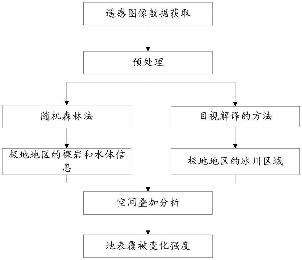
[0030] In the technical solutions disclosed in one or more embodiments, such as figure 1 As shown, a method for evaluating the intensity of surface cover change in polar regions includes the following steps:

[0031] Step 100: obtaining remote sensing image data of the polar regions to be identified and preprocessing;

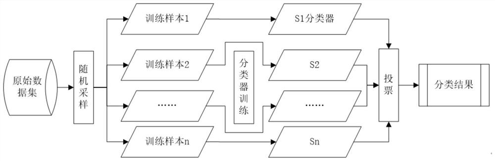
[0032] Step 200: According to the collected remote sensing data, use random forest classification to obtain bare rock and water body information in polar regions;

[0033] Step 300: According to the collected remote sensing data, use the method of visual interpretation to extract the outer edge of the glacier in the polar region to be identified, and use the threshold method to identify the type of the glacier;

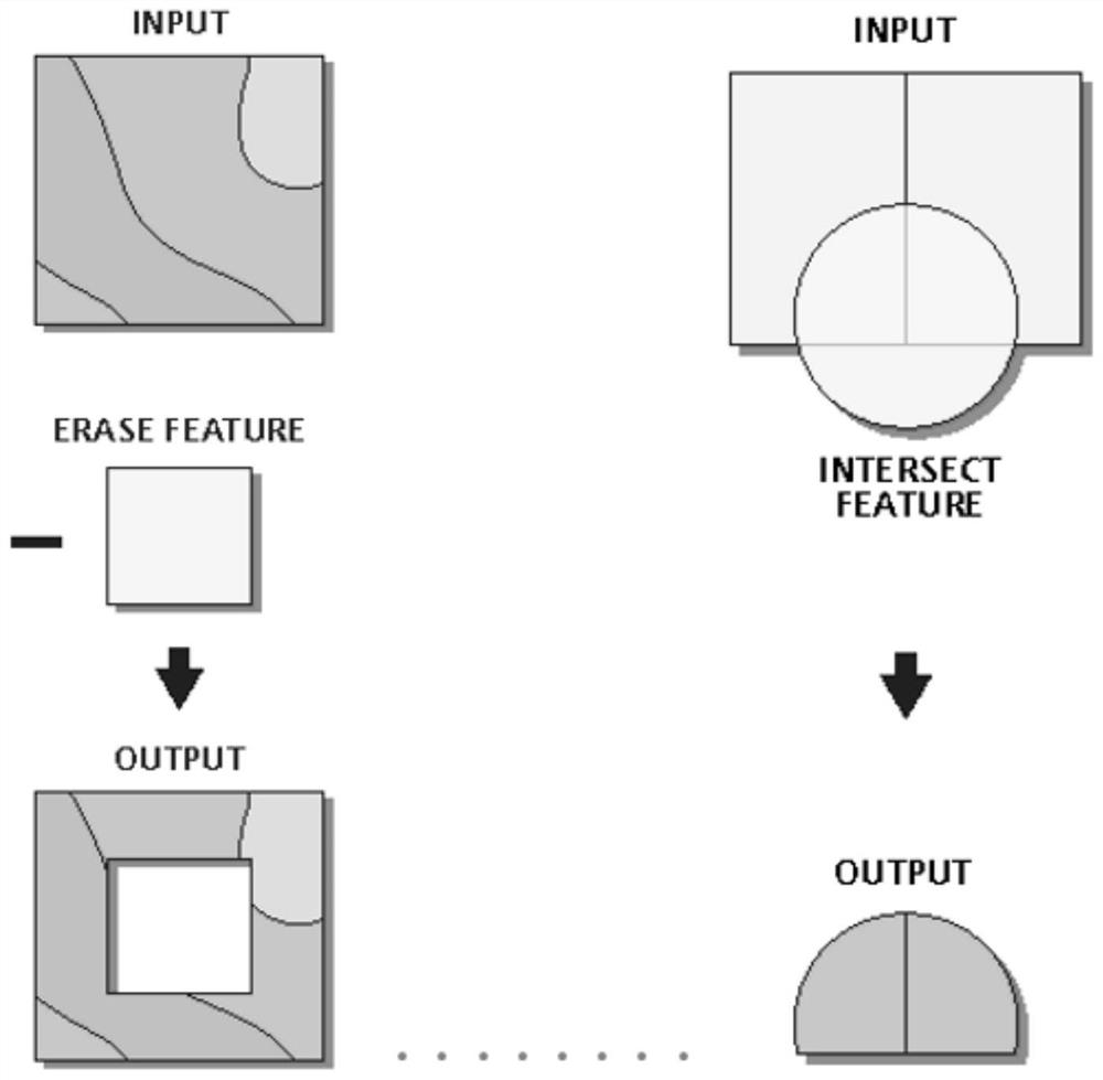
[0034] Step 400: Perform spatial overlay analysis on the glacier area, rock mass and water body area obtained according to the remote sensing image data obtained in different periods to obtain the change area, and calculate and obtain the change inten...

Embodiment 2

[0075] Based on Embodiment 1, this embodiment provides a system for evaluating the intensity of changes in surface cover in polar regions, including:

[0076] Acquisition module: configured to acquire remote sensing image data of the polar regions to be identified;

[0077] The first identification module: is configured to obtain the bare rock and water body information in the polar regions according to the remote sensing data, using random forest classification;

[0078] The second identification module: configured to extract the outer edge of the glaciers in the polar regions to be identified by visual interpretation according to the remote sensing data, and to identify the glacier type by the threshold method;

[0079] Analysis module: It is configured to perform spatial overlay analysis on the glacier area, rock mass and water body area obtained according to the remote sensing image data obtained in different periods, to obtain the change area, and to calculate the change ...

Embodiment 3

[0081] Based on Embodiment 1, this embodiment provides an electronic device, which is characterized in that it includes a memory, a processor, and computer instructions stored in the memory and executed on the processor. When the computer instructions are executed by the processor, the above-mentioned steps are completed. The steps described in the example method.


PUM


Abstract

The invention provides an earth surface cover change intensity evaluation method and system for a polar region. The method comprises the following steps: acquiring remote sensing image data of a to-be-identified polar region; according to the remote sensing data, adopting a random forest method for classification to obtain bare rock and water body information of the polar region; according to the remote sensing data, extracting the glacier outer edge in the polar region to be identified by adopting a visual interpretation method, and identifying the glacier type by adopting a threshold value method; spatial overlay analysis is carried out on glacier areas, rock mass areas and water body areas obtained according to remote sensing image data obtained in different periods, change areas are obtained, and the earth surface cover change intensity is obtained through calculation. According to the method, the remote sensing image is used as a data source to obtain the land cover change condition of a key area, the land cover of the Antarctic coastal zone area is classified, and the land cover change intensity analysis of the polar coastal zone area is realized by combining and applying a space analysis method and a statistical analysis method.

Description

technical field [0001] The present disclosure relates to the technical field related to remote sensing technology, and in particular, to a method and system for evaluating the intensity of changes in ground cover in polar regions. Background technique [0002] The statements in this section merely provide background information related to the present disclosure and do not necessarily constitute prior art. [0003] With the development of remote sensing and GIS technology, LUCC (land use / land cover change) research has gradually deepened and expanded, and different fields such as land management, ecological monitoring, and environmental protection have used this method to carry out related research. The existing land cover change evaluation methods are mainly applied to land, and the index system constructed is also mainly based on land cover types. Usually, statistical analysis methods are used to evaluate the changes in the area of ​​land use types per unit time, focusing o...

Claims


Application Information

Patent Timeline
IPC IPC(8): G06V20/10G06K9/62G06V10/774G06V10/764
CPCG06F18/24323G06F18/214Y02A90/30
Inventor 孙晓宇何亚文
Owner 国家海洋环境预报中心
Why Eureka
Try Eureka