
Vector map feature expression-based large-scene unmanned aerial vehicle image rapid positioning method

A vector map and feature expression technology, applied in vector format still image data, satellite radio beacon positioning system, image data processing and other directions, can solve problems such as low efficiency and low positioning accuracy

Active Publication Date: 2022-06-17
NO 54 INST OF CHINA ELECTRONICS SCI & TECH GRP
View PDF9 Cites 2 Cited by
  • Summary
  • Abstract
  • Description
  • Claims
  • Application Information

AI Technical Summary

Problems solved by technology

[0007] In order to solve the problem of low precision and low efficiency of vision-based autonomous positioning of UAVs in the prior art, the present invention proposes a fast positioning method for UAV images based on vector map feature expression, which describes the vector map through characterization , which can realize fast and high-precision matching of UAV images and vector maps

Method used


Image

  • Vector map feature expression-based large-scene unmanned aerial vehicle image rapid positioning method
  • Vector map feature expression-based large-scene unmanned aerial vehicle image rapid positioning method

Examples


Embodiment Construction

[0024] The specific embodiments of the present invention are described below with reference to the accompanying drawings, so that those skilled in the art can better understand the present invention.

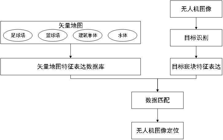
[0025] like figure 1 As shown in the figure, a method for fast positioning of large-scene UAV images based on the expression of vector map features includes the following steps:

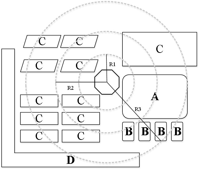
[0026] (1) Construct a vector map of the drone flight area. According to the approximate location of the drone, draw the vector patches of the football field, basketball court, building monomer, and water body area through the network public method or manual plotting, and create a Shapefile file. The football field is category A and the basketball field is category B, the single building is category C, and the water area is category D, and the area of ​​each patch is calculated at the same time;

[0027] (2) Characterize the vector map. like figure 2 As shown, take the center of gravity of each p...


PUM


Abstract

The invention discloses a vector map feature expression-based large-scene unmanned aerial vehicle image rapid positioning method, and belongs to the field of unmanned aerial vehicle positioning and navigation. According to the method, vector patches of four typical targets including a football field, a basketball field, a building monomer and a water body area are used as an unmanned aerial vehicle image positioning reference base map, and feature vector expression is performed on each vector patch; the method comprises the following steps of: quickly identifying four types of targets, namely a football field, a basketball field, a building monomer and a water body area, of a high-resolution remote sensing image acquired by an unmanned aerial vehicle, and performing feature vector calculation on a central patch of the image; and finally, feature vector matching is carried out, and rapid matching of the unmanned aerial vehicle image and the base map data is realized. According to the method, the data volume carried by the unmanned aerial vehicle can be greatly compressed, the image matching efficiency of the unmanned aerial vehicle can be greatly improved, and rapid positioning of the image of the unmanned aerial vehicle under the condition of large-scene GNSS signal rejection is realized.

Description

technical field [0001] The invention belongs to the field of UAV positioning and navigation, and particularly relates to a large-scene UAV image fast positioning method based on vector map feature expression, which can be used for an autonomous positioning method when the UAV loses satellite positioning signals in urban scenes. Background technique [0002] GNSS signals are widely used in real-time high-precision positioning of UAV systems. However, in urban scenes with many high-rise buildings, GNSS signal degradation or unavailability often occurs, causing the drone to "get lost" in the city. [0003] In order to solve the problem of autonomous positioning of UAVs, many researchers have proposed vision-based autonomous positioning methods for UAVs. These mainly include the following two: [0004] 1) Autonomous positioning method of UAV based on image matching. This method mainly uses the high-resolution remote sensing satellite image as the base map, and registers the i...

Claims


Application Information

Patent Timeline
Patent Type & Authority Applications(China)
IPC IPC(8): G06F16/56G06F16/583G06V20/10G06T11/20G06F16/29G01C21/00G01S19/48
CPCG06F16/56G06F16/583G06F16/29G06T11/206G01C21/005G01S19/485
Inventor 刘宇孙方德王港耿虎军朱进
Owner NO 54 INST OF CHINA ELECTRONICS SCI & TECH GRP
Learn More