
Method and device for calibrating laser radar and GPS (Global Positioning System) based on road-vehicle fusion perception

A vehicle-mounted laser radar and laser radar technology, applied in the field of laser radar and GPS calibration, can solve the problem of inability to provide accurate geographical environment data and target position information, and achieve the effect of small error, improved calibration accuracy and high precision

Pending Publication Date: 2022-07-15
BEIHANG UNIV
View PDF2 Cites 5 Cited by
  • Summary
  • Abstract
  • Description
  • Claims
  • Application Information

AI Technical Summary

Problems solved by technology

[0004] In view of this, the present invention provides a laser radar and GPS calibration method and device for road-vehicle fusion perception to solve the problem that automatic driving vehicles cannot provide accurate geographic environment data and target location information in the prior art

Method used


Image

  • Method and device for calibrating laser radar and GPS (Global Positioning System) based on road-vehicle fusion perception
  • Method and device for calibrating laser radar and GPS (Global Positioning System) based on road-vehicle fusion perception
  • Method and device for calibrating laser radar and GPS (Global Positioning System) based on road-vehicle fusion perception

Examples


Embodiment Construction

[0088] In the following description, for the purpose of illustration rather than limitation, specific details such as specific system structures and technologies are set forth in order to provide a thorough understanding of the embodiments of the present invention. However, it will be apparent to those skilled in the art that the present invention may be practiced in other embodiments without these specific details. In other instances, detailed descriptions of well-known systems, devices, circuits, and methods are omitted so as not to obscure the description of the present invention with unnecessary detail.

[0089] A method and device for calibrating lidar and GPS for road-vehicle fusion perception provided by the present invention will be described in detail below with reference to the accompanying drawings.

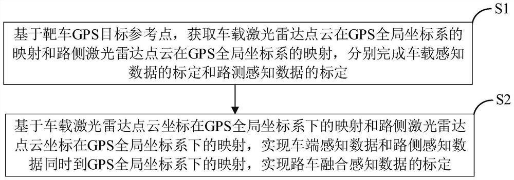
[0090] figure 1 It is a flow chart of a method for calibrating laser radar and GPS for road-vehicle fusion perception provided by the present invention;

[0091] I...


PUM


Abstract

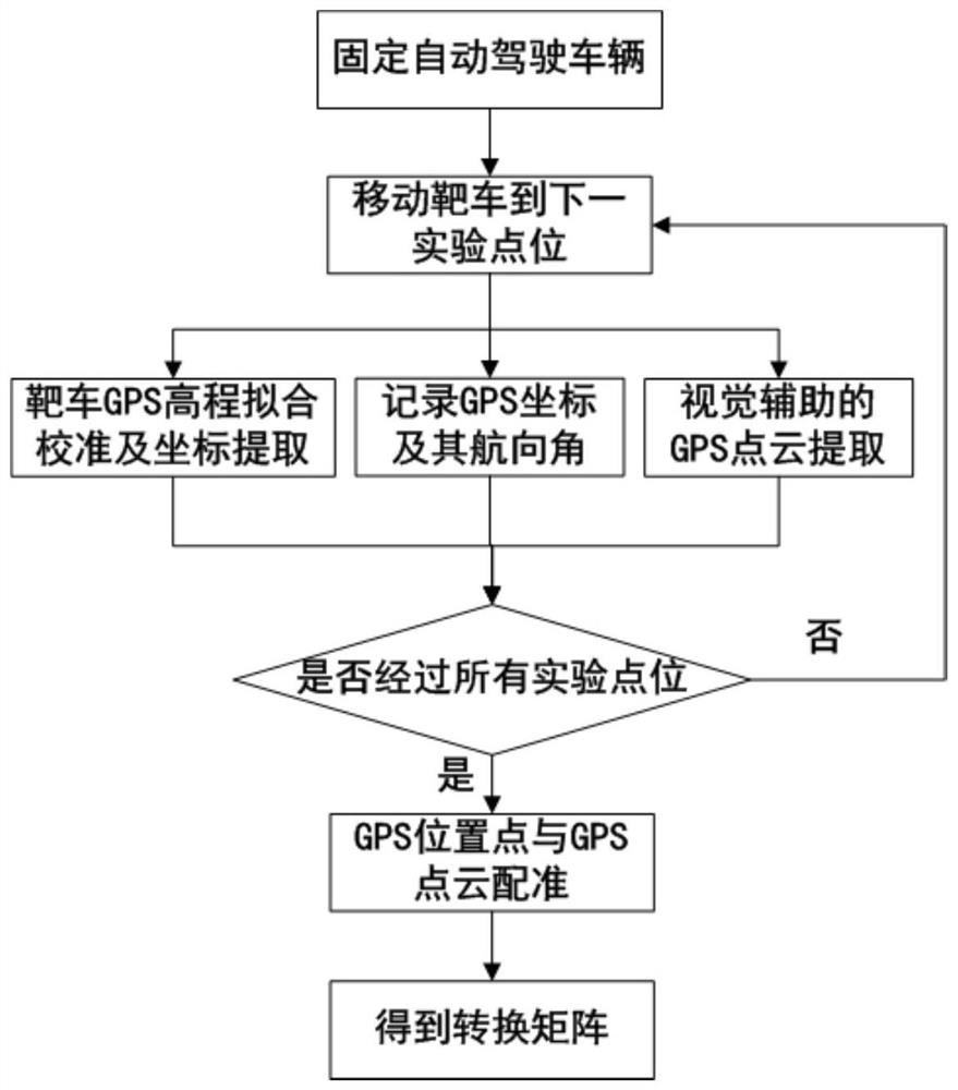
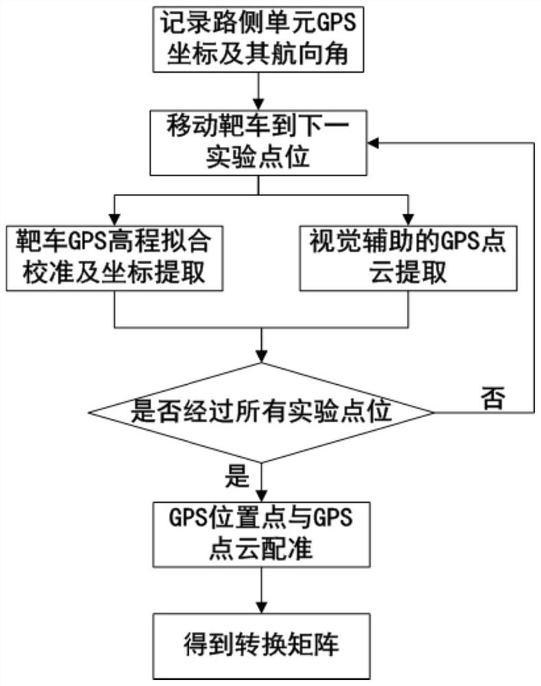
The invention relates to the technical field of automatic driving road-vehicle fusion perception, and provides a laser radar and GPS calibration method and device for road-vehicle fusion perception. The method comprises the following steps: based on a target vehicle GPS target reference point, obtaining the mapping of a vehicle-mounted laser radar point cloud in a GPS global coordinate system and the mapping of a roadside laser radar point cloud in the GPS global coordinate system, and respectively completing the calibration of vehicle-mounted sensing data and the calibration of roadside sensing data; mapping of the vehicle end sensing data and the roadside sensing data to the GPS global coordinate system at the same time is achieved, and calibration of the road-vehicle fusion sensing data is achieved. The invention provides a stable and reliable space synchronization method, the laser point cloud of the target vehicle GPS is captured with high precision, the GPS elevation noise data is eliminated, the laser radar point and the GPS coordinate of the GPS are effectively registered, the calibration precision is improved, and the automation and the intelligentization of the space-time synchronization marking of the vehicle end and the roadside equipment are realized.

Description

technical field [0001] The invention relates to the technical field of automatic driving road-vehicle fusion perception, in particular to a laser radar and GPS calibration method and device for road-vehicle fusion perception. Background technique [0002] 3D LiDAR is widely used in the field of autonomous driving perception due to its wide range, high precision and good adaptability. It provides three-dimensional environmental point cloud information for the vehicle by scanning the surrounding environment of the autonomous driving vehicle. As a high-precision positioning device, GPS cooperates with LiDAR and complements each other to provide accurate geographic environment data and target location information for autonomous vehicles. Due to the limited perception of bicycles, autonomous vehicles will have problems such as large blind spots and limited sensing distances when they work alone. The roadside perception unit is often used as a blind-filling device to perform fusio...

Claims


Application Information

Patent Timeline
Patent Type & Authority Applications(China)
IPC IPC(8): G01S7/497G01S19/23G06V20/56G06V10/80G06K9/62
CPCG01S7/497G01S19/23G06F18/251
Inventor 王章宇龚子任余贵珍周彬王昊
Owner BEIHANG UNIV
Learn More