Method and system for processing orthoimage of unmanned aerial vehicle

A technology of orthophotos and UAVs, which is applied in the field of aerial image processing, can solve the problems of insufficient precision of orthophotos and large discrepancies in situations, etc.

Inactive Publication Date: 2022-07-22
江苏复泽智能科技有限公司
View PDF0 Cites 0 Cited by
  • Summary
  • Abstract
  • Description
  • Claims
  • Application Information

AI Technical Summary

Problems solved by technology

[0005] This application provides a method and system for processing UAV orthophotos, which are used to solve the problem that the orthophotos obtained by UAV aerial survey processing and synthesis in the prior art have insufficient precision and are quite different from the actual situation in the area. question

Method used


Image

  • Method and system for processing orthoimage of unmanned aerial vehicle
  • Method and system for processing orthoimage of unmanned aerial vehicle
  • Method and system for processing orthoimage of unmanned aerial vehicle

Examples


Embodiment 1

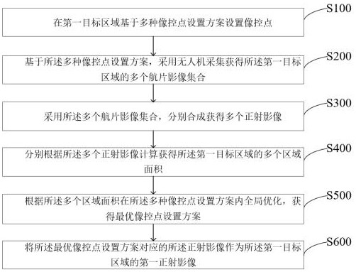
[0029] like figure 1 As shown, the present application provides a method for processing an orthophoto image of an unmanned aerial vehicle, and the method includes:

[0030] S100: setting image control points in the first target area based on various image control point setting schemes;

[0031] The first target area is any area that needs to use drones for remote sensing mapping, collecting aerial photo images and making orthophoto images, such as any area such as cities, rural areas, roads, fields, hills, depressions, etc. In the embodiment of the present application, the first target area is preferably an area where the terrain has a certain degree of complexity and it is difficult to perform on-the-spot measurement, such as areas such as terraces, depressions, and hills.

[0032] The image control point is the control point in the aerial survey. After the aerial photo image is collected and obtained, the image control point needs to be punctured to check the position and c...

Embodiment 2

[0124] Based on the same inventive concept as the method for processing an orthophoto image of a UAV in the foregoing embodiment, such as Figure 4 As shown, the present application provides a processing system for UAV orthophotos, wherein the system includes:

[0125] a first processing unit 11, configured to set image control points in the first target area based on a variety of image control point setting schemes;

[0126] a first obtaining unit 12, configured to obtain a plurality of aerial image sets of the first target area based on the plurality of image control point setting schemes;

[0127] The second processing unit 13 is configured to use the multiple aerial image sets to synthesize and obtain multiple orthophoto images respectively;

[0128] The third processing unit 14 is configured to calculate and obtain a plurality of area areas of the first target area according to the plurality of orthophotos respectively;

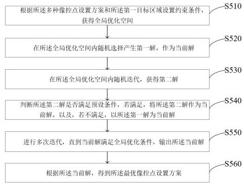
[0129] The fourth processing unit 15 is configur...

Embodiment 3

[0161] Based on the same inventive concept as the method for processing an orthophoto of an unmanned aerial vehicle in the foregoing embodiment, the present application also provides a computer-readable storage medium, where a computer program is stored on the storage medium, and the computer program is The method in Embodiment 1 is implemented when the processor executes.

[0162] Exemplary Electronics

[0163] Reference below Figure 5 to describe the electronic device of this application,

[0164] Based on the same inventive concept as the method for processing an orthophoto of an unmanned aerial vehicle in the foregoing embodiment, the present application further provides a system for processing an orthophoto of an unmanned aerial vehicle, including: a processor, the processor and a memory coupled, the memory is used for storing a program, and when the program is executed by the processor, the system enables the system to execute the steps of the method in the first embo...


PUM


Abstract

The invention provides an unmanned aerial vehicle orthoimage processing method and system, and the method comprises the steps: setting image control points in a first target region based on a plurality of image control point setting schemes; based on various image control point setting schemes, acquiring a plurality of aerial photo image sets of the first target area by adopting an unmanned aerial vehicle; a plurality of aerial photo image sets are adopted, and a plurality of orthoimages are obtained through synthesis; calculating a plurality of area areas of the first target area according to the plurality of orthoimages; performing global optimization in the plurality of image control point setting schemes according to the plurality of region areas to obtain an optimal image control point setting scheme; and taking the orthoimage corresponding to the optimal image control point setting scheme as a first orthoimage of the first target area.

Description

technical field [0001] The invention relates to the technical field of aerial image processing, in particular to a method and system for processing orthophoto images of unmanned aerial vehicles. Background technique [0002] UAV has become an important tool in low-altitude remote sensing surveying and mapping because of its ability to operate in complex terrain, flexible remote sensing, and low cost, and is widely used in surveying and mapping of complex terrain. [0003] At present, drones are used for remote sensing mapping, generally by setting image control points in the target area, and then using drones to collect field images of the target area under appropriate conditions, and then targeting based on the system algorithm built into the drone. Office processing synthesis of area 3D models and orthophotos. [0004] In the prior art, due to the angle, remote control point setting and other factors in the aerial survey and shooting process of the UAV, the orthophoto ima...

Claims


Application Information

Patent Timeline
Patent Type & Authority Applications(China)
IPC IPC(8): G06T7/62G06T7/00G06F17/18
CPCG06T7/62G06T7/0002G06F17/18G06T2207/10032G06T2207/20084G06T2207/20081
Inventor 史旻张坤
Owner 江苏复泽智能科技有限公司
Why Eureka
Try Eureka