Sound controlled interactive global navigation system and method

A navigation method and interactive technology, applied in the field of navigation systems, can solve the problems of prone to error in calibration, inconvenient operation, and easy to cause danger

Inactive Publication Date: 2006-10-18
滕春霖
View PDF0 Cites 2 Cited by
  • Summary
  • Abstract
  • Description
  • Claims
  • Application Information

AI Technical Summary

Problems solved by technology

However, the general GPS satellite navigation system for automobiles can only be used in China due to the lack of foreign electronic maps, and it will not work once it goes abroad; It is very inconvenient to operate while driving and is likely to cause dang

Method used


Image

  • Sound controlled interactive global navigation system and method
  • Sound controlled interactive global navigation system and method
  • Sound controlled interactive global navigation system and method

Examples


Embodiment Construction

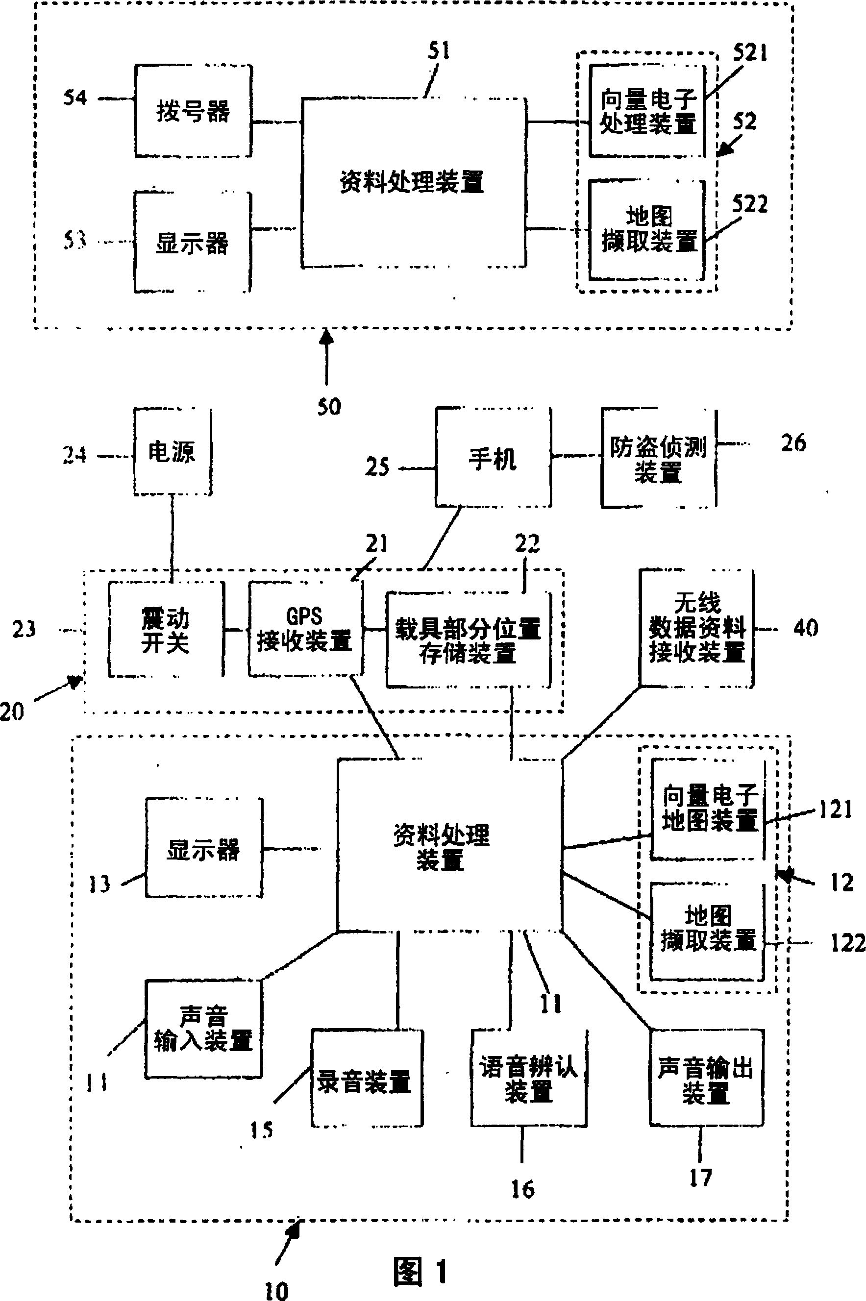
[0021] Please refer to shown in Fig. 1, the present invention includes a global navigation data processing device 10 connected to a mobile vehicle recording device 20 and a wireless data data receiving device 40; the global navigation data processing device 10 includes a data processing device 11 and Electronic map device 12, display 13, voice input device 14, recording device 15, voice recognition device 16, voice output device 17, etc. are connected. The data processing device 11 of the present invention can be classified into a portable personal computer (PC), a palmtop computer, or a navigation vehicle including a microprocessor (CPU). The electronic map device 12 includes a vector electronic map device 121 and a map retrieval device 122. The vector electronic map 121 can receive and store a vector electronic map. The website of the map downloads the relevant map, or the scanner is used to scan the required map, or the digital camera is used to capture the required map. T...


PUM


Abstract

The present invention utilizes the GPS receiving device to receive multiple GPS satellite signals, and can obtain information such as the position, speed, time, and traveling direction of the vehicle, and directly provide the global navigation data processing device for navigation. At the same time, the information such as the position, speed, time, and direction of travel of the vehicle captured by timing or fixed distance is stored in a part of the vehicle's position storage device; and the maps of all parts of the world are obtained by using the map capture device. After correction, it becomes a system Applicable electronic map, and also has monitoring and other entertainment functions.

Description

technical field [0001] The present invention relates to a navigation system and method for vehicle vehicles, and in particular to a voice-activated interactive navigation applicable to all parts of the world and having multiple functions. Background technique [0002] Vehicles have become an indispensable means of transportation for modern people. In order to improve the efficiency and convenience of driving, a variety of vehicles have introduced satellite positioning system (GPS) satellite navigation system, and the path of the vehicle is displayed on the electronic map of the display. , to guide the vehicle to the correct path of the target. However, the general GPS satellite navigation system for automobiles can only be used in China due to the lack of foreign electronic maps, and it will not work once it goes abroad; It is very inconvenient to operate while driving and is likely to cause danger; in addition, the path correction is based on the position of the vehicle di...

Claims


Application Information

Patent Timeline
IPC IPC(8): G01C21/26G01S5/00G08G1/0969
Inventor 滕春霖
Owner 滕春霖
Why Eureka
Try Eureka