Method for quickly providing position service and geography information

A location service and geographic information technology, applied in the field of GIS/GPS/LBS integrated information platform, can solve the problems of increasing the complexity of location-based application development, achieve high scalability and usability, simplify complexity, and protect privacy Effect

Inactive Publication Date: 2003-08-06
武汉奥发科技工程有限公司
View PDF0 Cites 53 Cited by
  • Summary
  • Abstract
  • Description
  • Claims
  • Application Information

AI Technical Summary

Problems solved by technology

Undoubtedly, the above two implementation methods greatly increase the complexity of location-based application development

Method used


Image

  • Method for quickly providing position service and geography information
  • Method for quickly providing position service and geography information

Examples


Embodiment Construction

[0034] The present invention will be further described below in conjunction with the accompanying drawings.

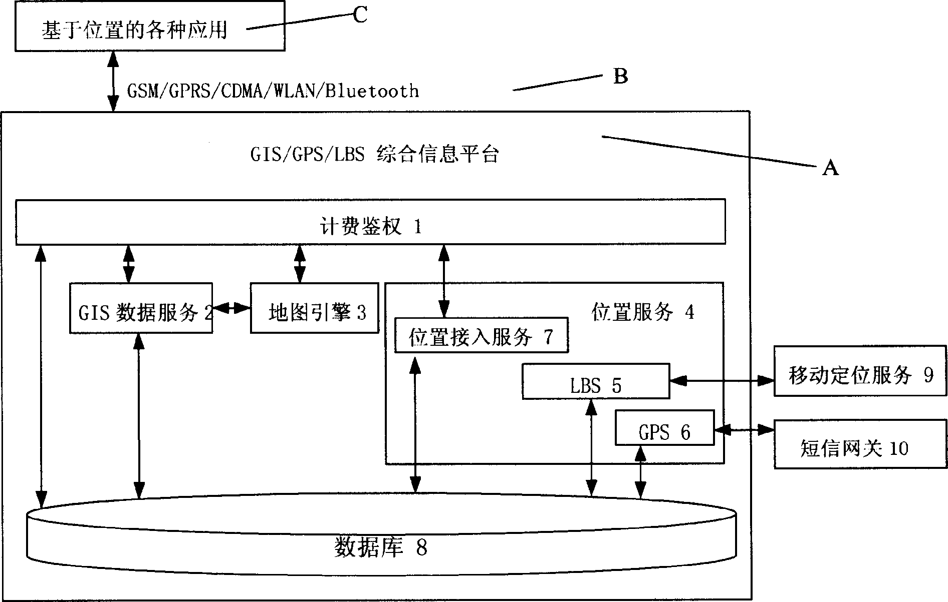
[0035] This integrated information platform A is connected to various location-based applications C through Internet access mode B; the integrated information platform A is composed of billing authentication 1, GIS data service 2, map engine 3, location service 4 and database 8 Composition; location service 4 is physically divided into three service programs: location access service 7, GPS location service 6, LBS location service 5; connection; billing authentication 1 is connected with database 8; GIS data service 2 is connected with map engine 3; LBS location service 5 is connected with mobile positioning service 9 through the Internet; GPS location service 6 is connected with Internet.

[0036] The GPS location service 6 should be connected to the SMS gateway server provided by the mobile communication operator for communication with the GPS terminal, wherein the GP...


PUM


Abstract

The invention discloses a method of rapidly providing position service and geographic information, referring to a method of wireless interconnectnig mobile position, and concretely the composition ofthe GIS / GPS / LBS synthetical informatino platform and the operating method. It provides the service of position and geophgraic information for all the applications based on position by adopting the techniques and the means such as Global Position System, handset mobile position system, wireless communication, Internet and geographic information system, depending on electronic map and based on mobile target position. The method includes GIS geographic information data service, position data service, inserted map engine and expense calculation and rigid identification.

Description

technical field [0001] The invention relates to a wireless interconnection mobile positioning method, in particular to the composition of a GIS / GPS / LBS integrated information platform and its operation method. Background technique [0002] Since the GPS (Global Positioning System) system was officially put into use in 1993, global GPS applications have entered a climax. Since GPS is a global, all-weather, continuous satellite radio navigation system, it can provide real-time three-dimensional coordinates, three-dimensional speed and high-precision time information. Because of its high positioning accuracy, fast speed, and no interference from occlusion, it is used in almost all fields of the national economy. Its application fields include: military surveying and mapping, precision surveying, geoscience research, precision agriculture, navigation and positioning, and traffic management. Now, the application of GPS in the fields of electric power, communication, and muni...

Claims


Application Information

Patent Timeline
Patent Type & Authority Applications(China)
IPC IPC(8): G01S5/02H04M11/00
Inventor 马洮安
Owner 武汉奥发科技工程有限公司
Why Eureka
Try Eureka