Vehicle navigation method capable of automatically correcting navigation track

A technology for navigation paths and vehicle navigation, which is applied to the traffic control system of road vehicles, road network navigators, instruments, etc., and can solve the problems of parking, poor navigation, and the inability of electronic maps to reflect traffic conditions at any time. Simple handling and the effect of preventing detours

Inactive Publication Date: 2007-02-28
XIAMEN YAXON NETWORKS CO LTD
View PDF1 Cites 30 Cited by
  • Summary
  • Abstract
  • Description
  • Claims
  • Application Information

AI Technical Summary

Problems solved by technology

This vehicle navigation method solves the problem that the original active navigation requires each navigation terminal to be equipped with an electronic map, and the road construction develops rapidly and the traffic control situation changes frequently. The electronic map equipped with each navigation terminal cannot reflect the real traffic conditions at any time. underperforming problems
However, it also has the following disadvantages: after the navigation terminal receives the navigation path data of the landmark point sequence on the navigation path, in the process of driving the vehicle according to the navigation path, once the driver makes a mistake in judgment and deviates from the navigation path, the driver needs to stop after finding out. Get off the car, log in the vehicle information to the navigation center again and request the navigation service
If the driver is not familiar with the roads in this place, it is difficult to find his mistakes, and the above method does not provide a solution to the problem of deviating from the navigation path. Therefore, once this driver deviates from the navigation path, he will not be able to get timely and effective navigation assistance.

Method used


Image

  • Vehicle navigation method capable of automatically correcting navigation track
  • Vehicle navigation method capable of automatically correcting navigation track
  • Vehicle navigation method capable of automatically correcting navigation track

Examples


Embodiment 1

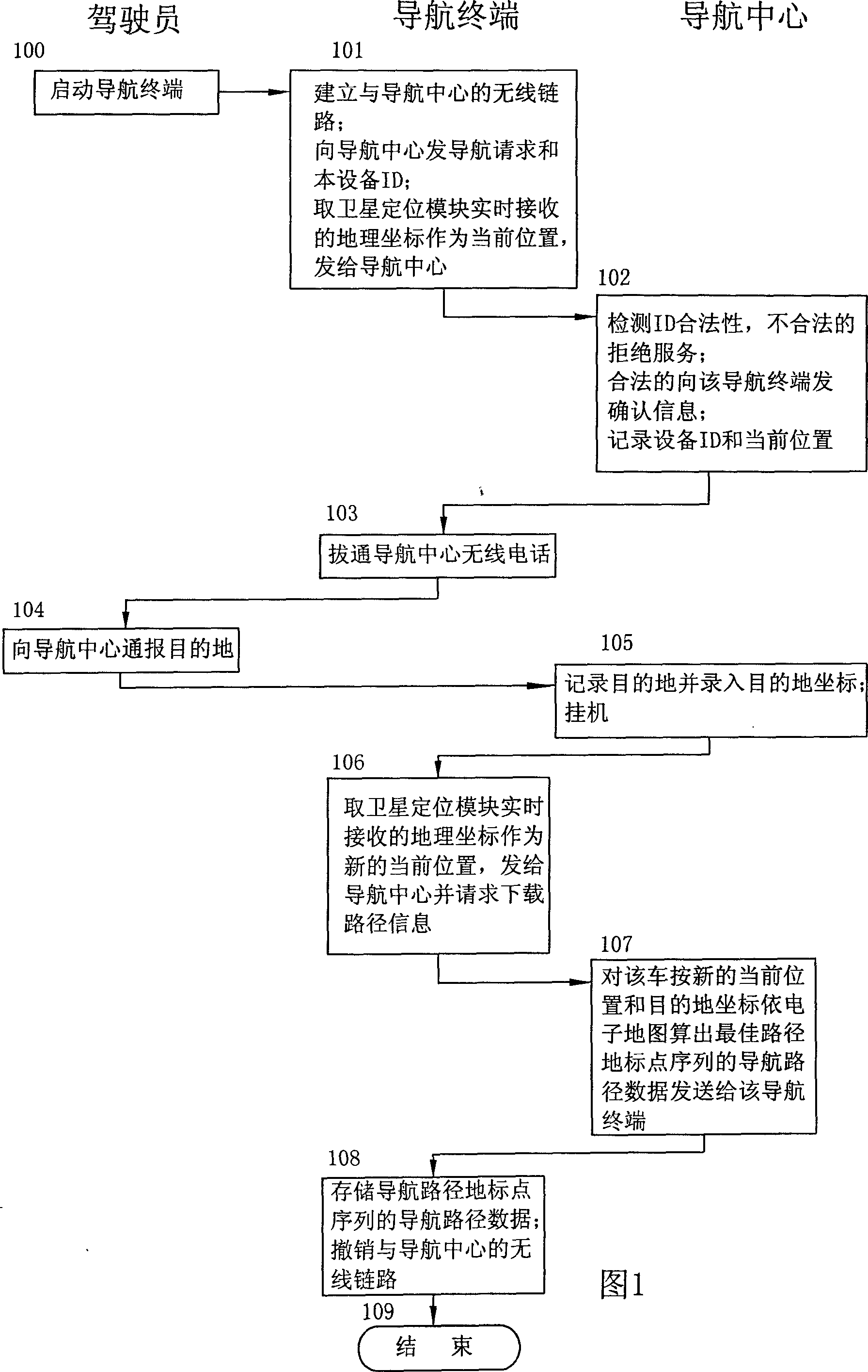
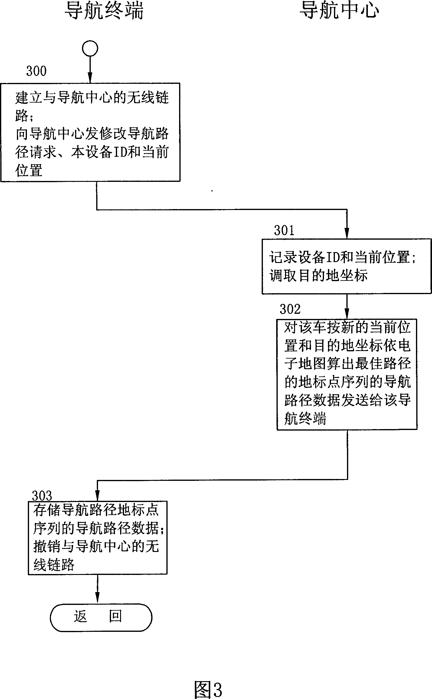
[0024] The vehicle navigation method for automatically correcting the navigation path of the present invention, the navigation terminal on the vehicle has a satellite positioning module, a communication module, a voice module and a display module; the navigation terminal can establish wireless data and voice communication with the navigation center through the communication module; the navigation center With the latest electronic map, the navigation center is staffed by service personnel 24 hours a day. The service personnel can answer the driver's phone call at the navigation terminal on the vehicle, log in the vehicle's identification code, current location and driving destination information and display them on the electronic map. Display the position of the vehicle and accept inquiries; the navigation center can also use the current position and destination of the vehicle to calculate the best route based on the electronic map, generate a set of navigation route data of a se...

Embodiment 2

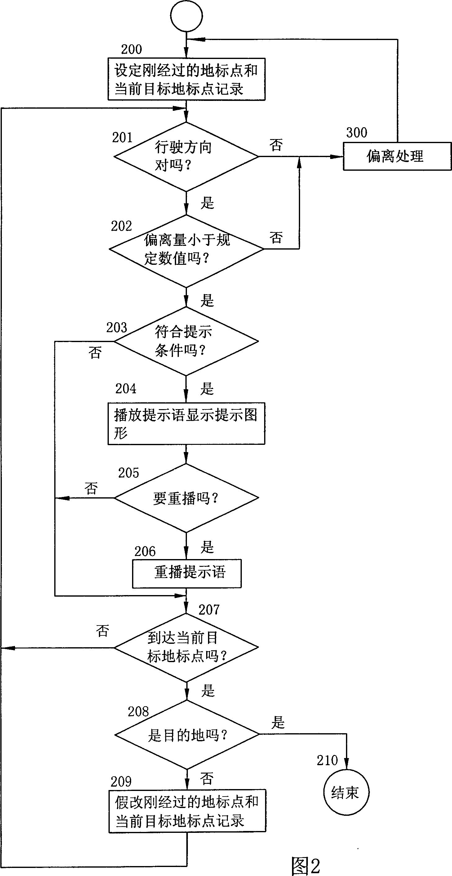
[0080] In the second embodiment of the present invention, on the basis of the previous embodiment, the nodes between two adjacent landmark points are used to divide the space between two adjacent landmark points into multiple navigation sections, so as to adapt to the sparseness of landmark points. And the road twists and turns. The data of each landmark point in the navigation route data of the landmark point sequence sent by the navigation center of this embodiment to the navigation terminal includes the longitude and latitude of the landmark point, the vehicle driving direction, the navigation prompt voice information code, and the abstract graphic navigation guidance information code. In addition to the advance reminder distance, it also contains the number of nodes between the local punctuation point and the next landmark point and the position of each node. The navigation terminal uses the coordinates of two adjacent nodes in each navigation section to judge the driving ...


PUM


Abstract

The invention relates to a vehicle navigation method which can automatically correct navigation path, especially a traffic control method for transmitting navigation instruction to the vehicle with planet positioning and communicating devices, wherein said method comprises: the navigation terminal of vehicle receives and stores the navigation path data of group ground mark sequence provided by the navigation center; when driving, the navigation terminal, based on present ground mark, judges if the driving direction is normal and the bias amount with present navigation road, and if said vehicle is deflected from present navigation path, sends vehicle recognize code and present position to the navigation center; the navigation center based on electric map calculates out the navigation path data of one group of ground mark sequence to be sent to the navigation terminal; and the navigation terminal via the navigation path data plays the instruction voice of present target ground mark and plays navigation instruction information; when the vehicle reaches target ground mark, the navigation terminal based on navigation path refreshes present target ground mark.

Description

technical field [0001] The invention relates to a traffic control method for road vehicles, in particular to a traffic control method for transmitting navigation instructions to vehicles with satellite positioning and communication equipment. technical background [0002] Chinese Invention Patent Application Publication CN 1409280A discloses a patent application number of 02128801.1 and a technical solution titled "Urban Intelligent Traffic and Vehicle Navigation System", in which a method for urban vehicle navigation is proposed: the user logs in the vehicle information to the navigation center by phone and Requesting navigation services, the navigation center records the current location and destination of the vehicle, calculates the route based on the electronic map, generates a set of navigation route data of a series of landmark points on the route, and sends it to the navigation terminal equipped on the user's vehicle. When the vehicle arrives at a landmark point of th...

Claims


Application Information

Patent Timeline
Patent Type & Authority Applications(China)
IPC IPC(8): G01C21/26G08G1/0968G08G1/123
Inventor 韦昌荣陈从华黄朝阳陈典全时宜
Owner XIAMEN YAXON NETWORKS CO LTD
Why Eureka
Try Eureka