
Fluid resonant seismic surveying

a technology of fluid resonant seismic and surveying, which is applied in the field of measuring and determining the location of oil and gas deposits, can solve the problems of not taking into account the energy and the uncertainty of the source of the noise of oil or gas

Active Publication Date: 2019-12-31
INT SEISMIC DATA PROCESSING CORP
View PDF8 Cites 5 Cited by
  • Summary
  • Abstract
  • Description
  • Claims
  • Application Information

AI Technical Summary

Benefits of technology

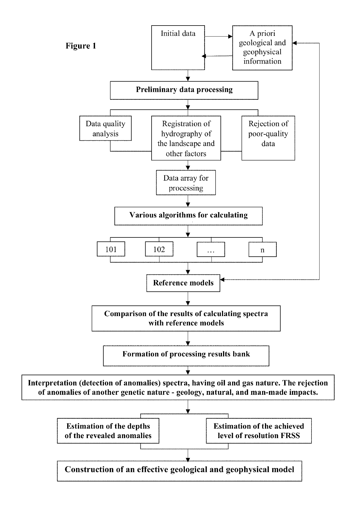
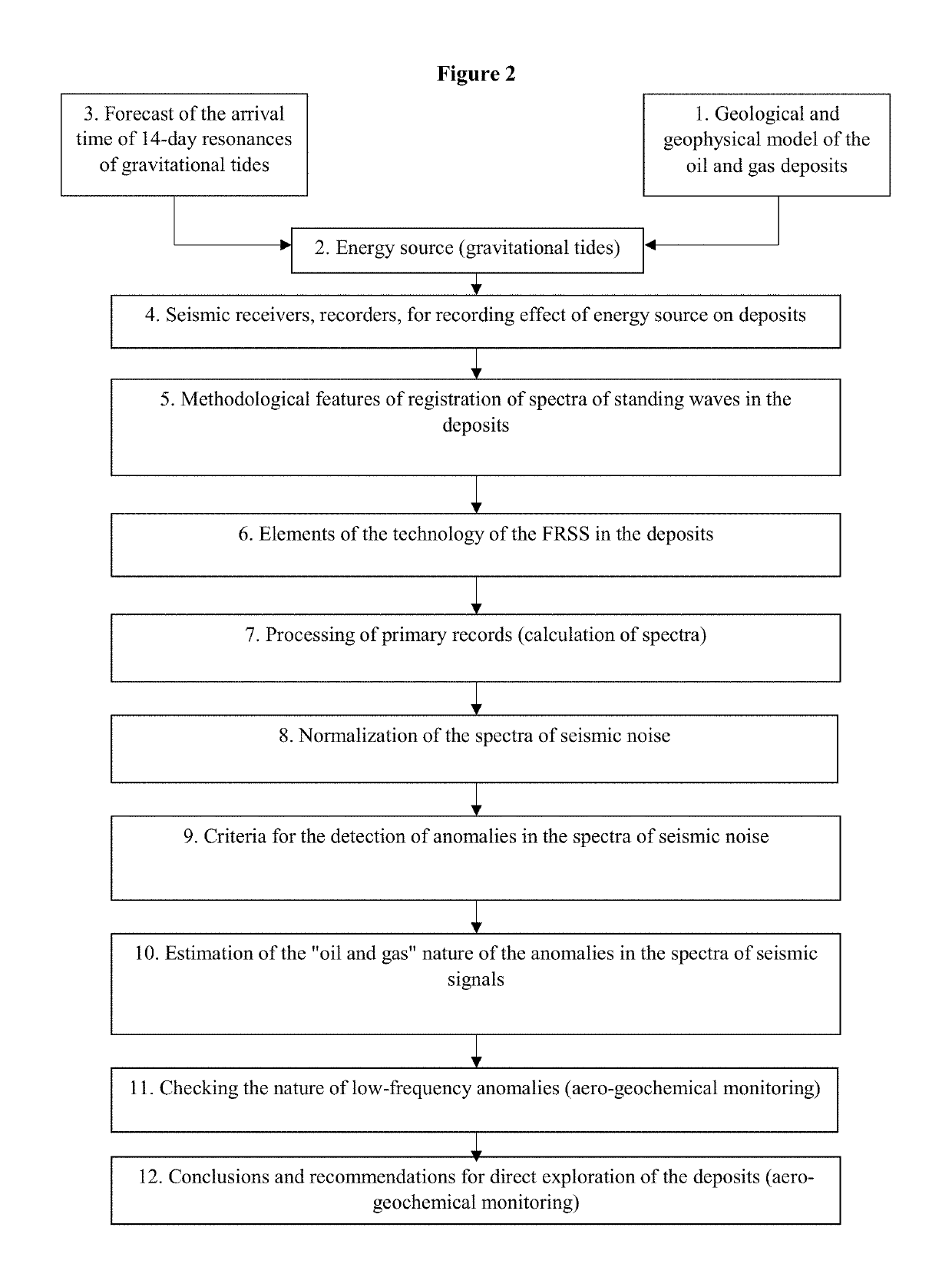
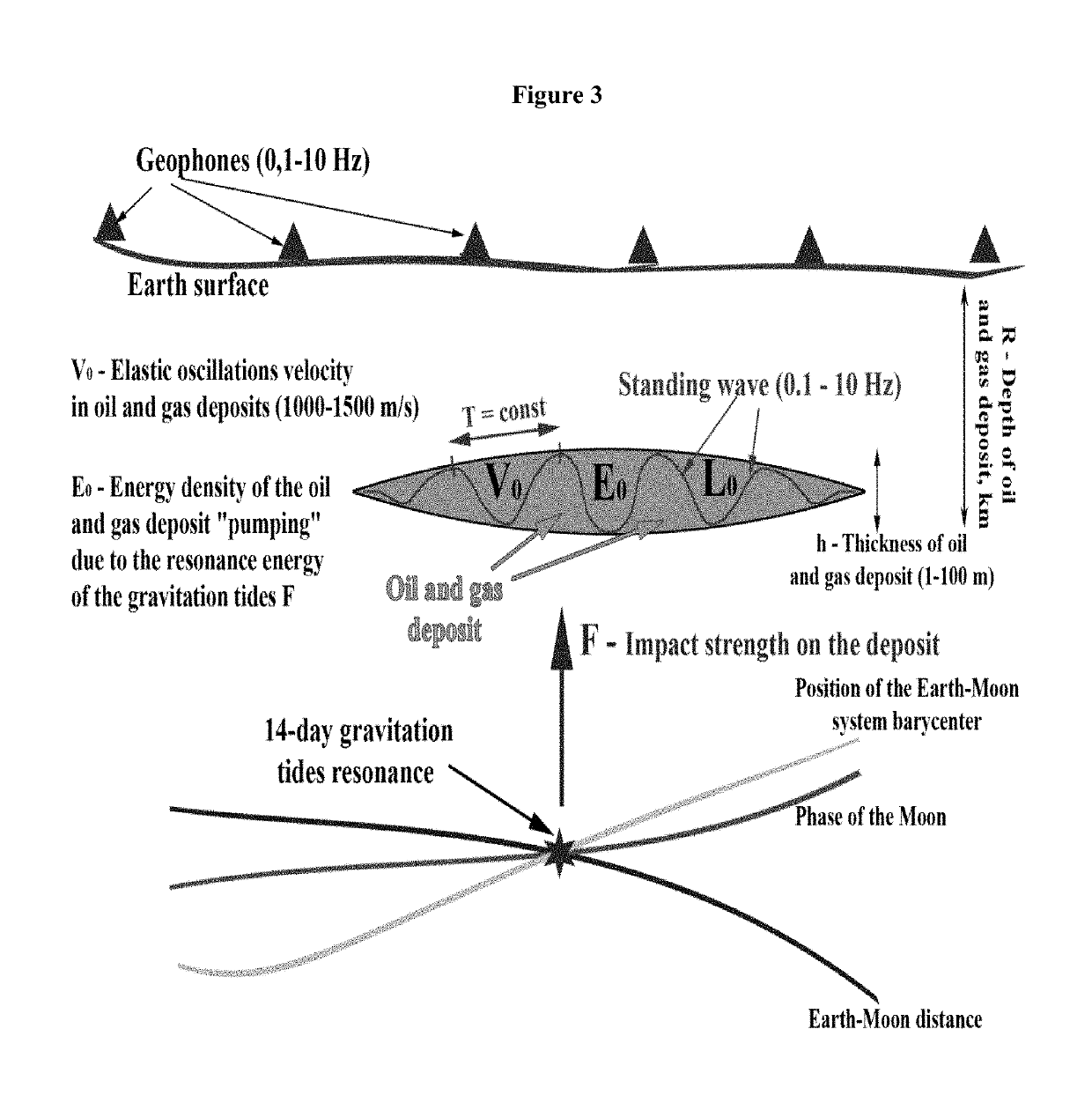
The present invention is about a technology that uses FRSS (Fourier-Rayleigh surface scattering) to record the energy of 14-day resonances of gravitational tides as they affect deposits within a geological formation. The tides are caused by the interaction between the gravitational force from the Earth and solar and extra-solar stress waves. By calculating the time of onset of these resonances, the technology predicts optimal times for surveying. The technical effect of the technology is an improved method for predicting optimal times for surveying.

Problems solved by technology

In such “passive” seismic technologies, the energy source of the noise of the oil or gas is unknown and is not taken into account when analyzing low-frequency noise records.

Method used


Image

  • Fluid resonant seismic surveying
  • Fluid resonant seismic surveying
  • Fluid resonant seismic surveying

Examples


Embodiment Construction

Definitions

[0020]FRSS. “Fluid Resonant Seismic Survey technology,”“FRSS technology,” or “FRSS,” as used herein, is defined as the registration and recording of tidal influences on oil and gas deposits below the Earth's surface.

[0021]The invention comprises methods, systems, and devices for the registration of natural oscillations of fluid oil and gas environments under the influence of gravitational tide resonances in the Earth's crust for the purpose of predicting locations of fluid and oil deposits. The invention comprises a Fluid Resonance Seismic Survey (FRSS) technology for directly forecasting locations of oil and gas deposits.

[0022]The technology is based on the recording of natural (i.e. not man-made) oscillations of oil and gas environments under the influence of the energy of resonances of the gravitational tides. The recording is performed by low-frequency geophones (0.1-10 Hz). The registration of an oil or gas deposit's own noise (i.e. vibration) is based on “passive” s...


PUM


Abstract

Methods, systems, and devices for the location of oil and gas deposits are disclosed. The technology is based on the recording of natural (i.e. not man-made) oscillations of oil and gas environments under the influence of the energy of resonances of the gravitational tides. The recording is performed by low-frequency geophones (0.1-10 Hz). The resonances are recorded, graphed, and analyzed. The time of the onset of the resonances of 14-day gravitational tides is pre-calculated by adding the tidal waves from the Moon, the Sun, and the stress wave arising in the Earth's lithosphere in connection with the periodic oscillation of the position of the barycenter of the Earth-Moon system. The calculation of the time of the onset allows for the prediction of optimal times for surveying according to the method of the present invention.

Description

FIELD OF THE INVENTION[0001]This invention relates to the measuring and determining of the location of oil and gas deposits.BACKGROUND OF THE INVENTION[0002]It is known that the oil and gas deposits (OGD) in the Earth's crust, due to their higher compressibility in comparison with the its surroundings within the ground, generate their own oscillations (i.e., the “Anchar” effect) under the influence of both man-made and natural factors.[0003]Newton, on the basis of the law of universal gravitation,[0004]F=G⁢m1⁢m2r2,G=6.67×10⁻¹¹,explained the nature of tides in the seas and oceans. Gravitational tides extend past the visible marine environment into the Earth's crust. Modern high-precision gravimeters and GPS-receivers allow for the registration and study of the effect of tidal waves on oil and gas deposits within a geological environment. The effect of tidal waves results in vertical fluctuations of rock and rock particles. These fluctuations cause changes in the properties of the str...

Claims


Application Information

Patent Timeline
Patent Type & Authority Patents(United States)
IPC IPC(8): G01V1/02G01V1/30G01V1/24G01V1/18
CPCG01V1/307G01V1/02G01V1/247G01V1/181G01V2210/1232G01V2210/123G01V1/288G01V9/00G01V7/00
Inventor SIBGATULIN, VIKTORKUKHAREV, VADIMTOLKACHEV, VLADIMIRBONDARENKO, VIKTORMILETENKO, IGORBORISOV, DMITRII
Owner INT SEISMIC DATA PROCESSING CORP
Learn More