Method for localizing a more automated, e.g., highly automated vehicle (HAV) in a digital localization map

a technology of highly automated vehicles and localization maps, applied in vehicle position/course/altitude control, using reradiation, instruments, etc., can solve the problems of unnecessary transmission of data, landmarks may also be hidden and therefore cannot be sensed by the hav, and the use of ever more complex driver-assistance systems is being employed, so as to improve the robustness and accuracy, neither time nor computing capacity is wasted

Active Publication Date: 2021-09-14
ROBERT BOSCH GMBH
View PDF12 Cites 0 Cited by
  • Summary
  • Abstract
  • Description
  • Claims
  • Application Information

AI Technical Summary

Benefits of technology

[0005]Therefore, an object of the present invention is to provide an improved method for localizing a highly automated vehicle (HAV) in a digital localization map.
[0013]According to the present invention, a driver-assistance system is thus disclosed for highly automated vehicles, which detects landmarks for localizing the vehicle with the aid of on-board driving-environment sensors. In addition, the landmarks are classified and possibly assigned the attribute “semi-static.” In principle, it is possible that, in addition, information is transmitted from the vehicle to the server, possibly the backend server, with which the server is able to update a hypothesis about the inserted attribute “hidden” or “visible.” By omitting the hidden landmarks when transmitting the local driving-environment model in the form of a digital localization map to the HAV, robustness and accuracy of the localization is increased, since in this case, the driver-assistance system of the HAV as well as the allocated driving-environment sensors of the HAV waste no computing capacity and time in identifying the landmarks which are not visible in any case, and matching them to a more comprehensive feature map expected.
[0019]In particular, this yields the technical advantage that the driver-assistance system detects semi-static objects such as trash cans, parked vehicles or trailers, for example, classifies them and transmits their contour and geo-position to the server. Based on the traveled trajectory and the traffic-lane geometries available, the server then calculates for the approaching vehicles whether there is a possibility that landmarks located currently or in the future in the environment of the HAV could be hidden.
[0024]In particular, the design approach of the present invention yields the technical advantage of improving the robustness and accuracy when localizing a HAV, since in the case of temporary obscurations, data to be transmitted between the server and the vehicle is reduced. Thus, neither time nor computing capacity is wasted on the part of the vehicle in detecting landmarks which are not visible in any case, and matching / comparing them to a more extensive feature map.
[0025]A further advantage is that a sufficient number of landmarks are always able to be detected for the matching, and in this way, are available in the map. In addition, obscuration situations of landmarks stored on the server may be ascertained on the basis of the reports back from the vehicles, thereby again allowing reliable localization of a highly automated vehicle in a digital map.

Problems solved by technology

In view of an increase in the degree of automation of vehicles, ever more complex driver-assistance systems are being employed.
At the same time, however, it proves to be disadvantageous that landmarks may also be hidden and therefore cannot be sensed by the HAV.
This leads, on one hand, to an unnecessary transmission of data, and on the other hand, to possibly poor localization accuracy, since insufficient information is available for a matching.
However, this is incompatible with high system reliability, which is necessary for automated driving.

Method used


Image

  • Method for localizing a more automated, e.g., highly automated vehicle (HAV) in a digital localization map
  • Method for localizing a more automated, e.g., highly automated vehicle (HAV) in a digital localization map

Examples


Embodiment Construction

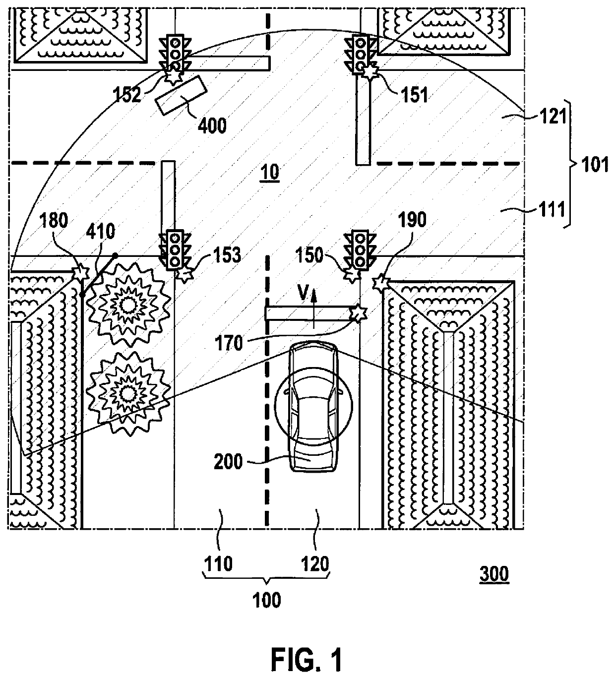
[0030]FIG. 1 shows a traffic junction 10 at which two road sections 100, 101, each having two lanes 110, 120, 111, 121, intersect, that are drivable by a more automated vehicle, especially by a highly automated vehicle (HAV) 200. The traffic at traffic junction 10 is regulated, inter alia, by traffic lights 150, 151, 152, 153. In addition, a first building corner 180 and a second building corner 190 are located in the surroundings of traffic junction 10. For the purposes of this example, it shall be assumed that traffic lights 150, 151, 152, 153, building corners 180, 190 as well as a stop line 170 are available in geo-referenced form and as permanent landmarks for generating a digital driving-environment model.

[0031]That means that, for example, certain features of building corner 180 necessary for recognizing building corner 180, as well as its position in a suitable coordinate system are stored in a data store in digital form and for creating a driving-environment model for a HAV...


PUM


Abstract

A method is described for localizing a highly automated vehicle (HAV) in a digital localization map, including the following steps: S1 sensing features of semi-static objects in an environment of the HAV with the aid of at least one first sensor; S2 transmitting the features of the semi-static objects as well as the vehicle position to an evaluation unit; S3 classifying the semi-static objects, the feature “semi-static” being assigned to the semi-static objects as a result of the classification; S4 transferring the features of the semi-static objects into a local driving-environment model of the HAV, when creating the local driving-environment model, it being checked whether landmarks suitable for localizing the HAV are hidden by the semi-static objects in terms of the position and / or an approach trajectory of the HAV; S5 transmitting the local driving-environment model to the HAV in the form of a digital localization map, the digital localization map containing only those landmarks suitable for localizing the HAV which are not hidden by semi-static objects in terms of the position and / or an approach trajectory of the HAV; and S6 localizing the HAV using the digital localization map. In addition, a corresponding system and computer program are described.

Description

FIELD OF THE INVENTION[0001]The present invention relates to a method and a system for localizing a more automated, e.g., highly automated vehicle (HAV) in a digital localization mapBACKGROUND INFORMATION[0002]In view of an increase in the degree of automation of vehicles, ever more complex driver-assistance systems are being employed. For such driver-assistance systems and functions such as highly automated driving or fully automated driving, a great number of sensors are needed in the vehicle which permit exact sensing of the vehicle environment. In order to control the vehicle in more automated fashion, it is necessary, for example, to reliably recognize the traffic lanes, so that the vehicle may be guided within a recognized traffic lane. In the following, the term more automated is understood to mean all those degrees of automation which, in accordance with the Bundesanstalt für Straßenwesen (BASt) (German Federal Highway Research Institute), correspond to automated longitudina...

Claims


Application Information

Patent Timeline
Patent Type & Authority Patents(United States)
IPC IPC(8): G01C21/30G06K9/00G01S13/06G05D1/02G08G1/09
CPCG06K9/00825G01C21/30G01S13/06G05D1/0274G05D2201/0213G01S11/12G01C21/28G05D2201/0212G06V20/584
Inventor MIELENZ, HOLGERROHDE, JAN
Owner ROBERT BOSCH GMBH
Why Eureka
Try Eureka