Spatial surface prior information reflectance estimation (SPIRE) algorithms

a technology of prior information reflectance and estimation algorithms, applied in the field of spectroscopy, can solve the problems of surface reflectance estimation, worse estimates in these areas, and elm also suffers, so as to improve standard deviation and rms performance, and remove additive noise

Inactive Publication Date: 2005-02-17
AIR FORCE GOVERNMENT OF THE US SEC THE
View PDF6 Cites 29 Cited by
  • Summary
  • Abstract
  • Description
  • Claims
  • Application Information

AI Technical Summary

Benefits of technology

FIGS. 1a-1c are illustrations of multiplicative-noise-only problem and algorithm depicted in the log spatial frequency domain. (a) log image spectrum Ilog%(φ) containing multiplicative noise M%log(φ). (b) Ilog%(φ) after noise is excised. (c) log surface reflectivity spectrum estimate {circumflex over (R)}log%(φ) after the prior low frequencies are inserted.
FIG. 2. (a) Multiplicative-noise-only spatial SPIRE algorithm tested and (b) the generalized processing block diagram. The high-pass-filtered log image is merged with an estimate of the lost low frequency components of the original log image derived from the prior. The exponential is then taken to estimate reflectance.
FIG. 3. Spatial SPIRE algorithm processing block diagram for multiplicative and additive noise. The sensed image is first high-pass filtered to remove the additive noise α. A loop is then entered to estimate the rm*h1 lost using a Discrete Cosine Transform (DCT). The number of DCT coefficients needed is derived from the band limit φα-a. For each DCT coefficient, a mean-square-error minimization loop estimates the correct value. The estimate of rm*h1 is then added and the multiplicative-noise-only algorithm obtains the final estimated reflectance.
FIG. 4. Scatter plot of mean and standard deviation performance of spatial SPIRE (diamonds), ELM (*), and ATREM (+) for estimation of surface spectral reflectance for all 19 pixel types. The horizontal axis represents the average standard deviation over all 73 spectral channels, where the standard deviation in each channel was calculated over the reflectance estimates of all six runs (Runs 06, 07, 13, 22, 26, and 31). The vertical axis is the RMS error over all spectral channels for the mean reflectance estimate minus the mean reflectance estimate of ELM as ground truth, which is why ELM has zero RMS error. The larger symbols represent the mean of the points plotted with that symbol. We see that spatial SPIRE has better standard deviation and RMS performance than ATREM.
FIG. 5 (a) and (b). ELM, ATREM, and Spatial SPIRE spectral reflectance estimates for all six runs for a single pixel on the spectral panel (a) and mowed grass (b). There are six bands of contiguous channels left after dropping problem channels, defined as Bands 1-6 as depicted in the upper left plot of the spectral panel reflectance. FIG. 5 (c) and (d). ELM, ATREM, and Spatial SPIRE spectral reflectance estimates for all six runs for the modified pixel (c) and the 2 percent panel (d). Spatial SPIRE's poor performance at longer wavelengths on the 2 percent panel is due to errors in estimating the additive noise α under low SNR conditions. FIG. 7. Classification results for the Run 13 (a) and Run 06 (b) estimated reflectance cubes from ELM, ATREM, and Spatial SPIRE algorithms. Run 13 and the training data from Run 07 were collected on the same day under similar illumination conditions as. The Run 06 data occurred on a different day with different illumination conditions.

Problems solved by technology

A fundamental problem in many imaging and remote sensing problems is the estimation of the surface reflectance of objects and materials in an imaged scene.
However, if there are spatially varying effects over parts of the image where there are no ground truth points, then the estimates in these areas will be worse.
The ELM also suffers where the images do not have well calibrated test panels for which ground truth spectra are available.
Even if a prior reflectance image exists which could provide “truth” spectra, the random location of changes in subsequent images makes it difficult to select automatically the spectra to use.
Most atmospheric physics-based codes assume a clear, cloudless day, and their performance degrades when there are overcast clouds or haze.

Method used


Image

  • Spatial surface prior information reflectance estimation (SPIRE) algorithms
  • Spatial surface prior information reflectance estimation (SPIRE) algorithms
  • Spatial surface prior information reflectance estimation (SPIRE) algorithms

Examples


Embodiment Construction

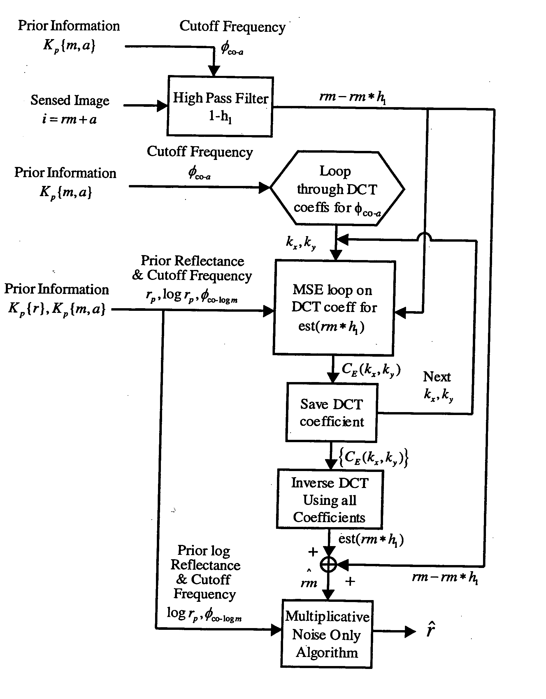
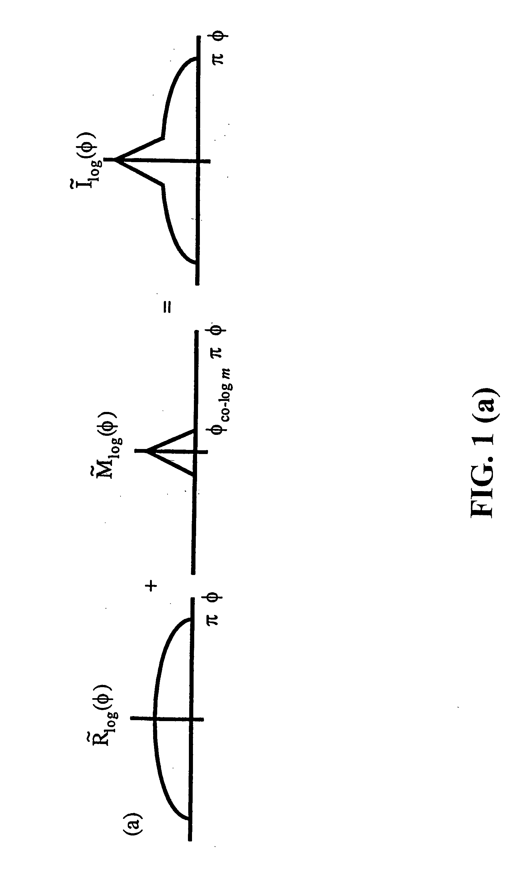
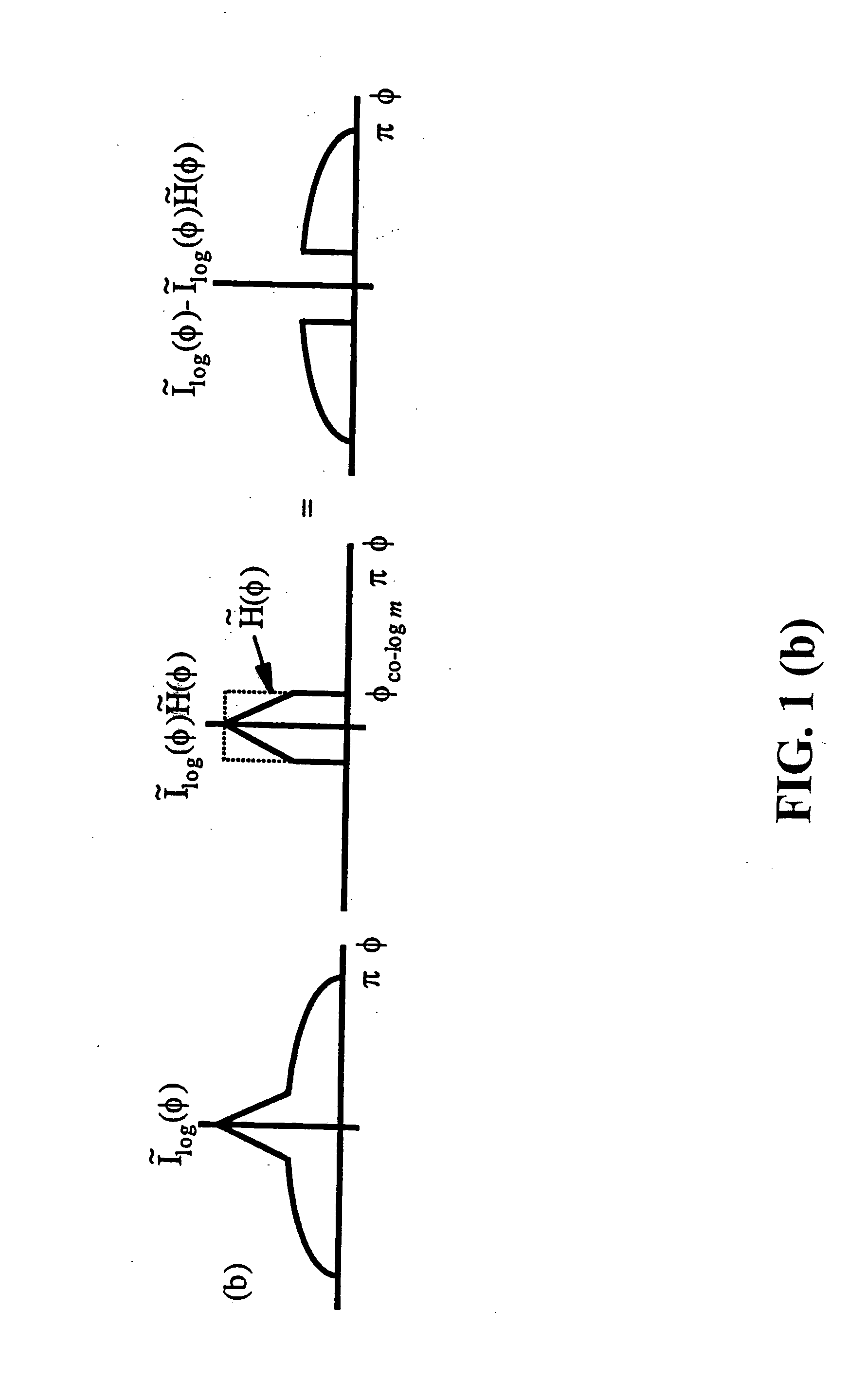
The goal of this invention is to compensate for atmospheric effects using only prior spatial information about the scene. The motivation for this was threefold. First, such an approach would likely work better than an atmospheric physics-based method when using airborne sensors since it is not dependent on the unknown state of the atmosphere above the sensor. Second, the repetitive and increasing amount of remote sensing data collected promises to eventually provide the needed prior surface reflectance information. Third, lightness algorithms that model the human visual system's ability to achieve color constancy over varying illumination conditions (multiplicative noise only) through spatial processing helped to inspire this effort to develop related algorithms for remote sensing applications.

This is the first development of a new class of algorithms that use prior surface reflectance information to correct for multiplicative and additive noise introduced by variations in illumi...


PUM

PropertyMeasurementUnit
Spatial SPIRE spectral reflectanceaaaaaaaaaa
surface reflectanceaaaaaaaaaa
reflectanceaaaaaaaaaa

Abstract

A new class of algorithms has been developed to estimate spectral reflectance in remote sensing imagery. These algorithms are called Surface Prior Information Reflectance Estimation (SPIRE) algorithms and estimate surface spectral reflectance using prior spatial and spectral information about the surface reflectance. This paper describes SPIRE algorithms that employ spatial processing of single channel data to estimate local changes in spectral reflectance under spatially and spectrally varying multiplicative and additive noise caused by variations in illumination and atmospheric effects. Rather than modeling the physics of the atmosphere and illumination (using a physics-based code such as ATREM), or using ground truth spectra at known locations to compensate for these effects (using the Empirical Line Method), prior information about the low spatial frequency content of the scene in each spectral channel is used instead. HYDICE VNIR-SWIR hyperspectral data were used to compare the performance of SPIRE, ATREM, and ELM atmospheric compensation algorithms. The Spatial SPIRE algorithm performance was found to be nearly identical to the ELM ground-truth based results, while Spatial SPIRE performed better than ATREM overall, and significantly better under high clouds and haze.

Description

BACKGROUND OF THE INVENTION The present invention relates generally to spectroscopy and more specifically to a new class of algorithms to estimate spectral reflectance in remote sensing imagery. These algorithms are called Surface Prior Information Reflectance Estimation (SPIRE) algorithms and estimate surface spectral reflectance using prior spatial and spectral information about the surface reflectance. A fundamental problem in many imaging and remote sensing problems is the estimation of the surface reflectance of objects and materials in an imaged scene. The measured scene radiance is generated by complex physical interactions between the source illumination, material surfaces, and the intervening atmosphere. Changes in atmospheric conditions and the relative positions of the sensor, surface, and illumination source introduce variations between images of the same scene collected at different times. These changing illumination and backscatter effects must be compensated in orde...

Claims


Application Information

Patent Timeline
Patent Type & Authority Applications(United States)
IPC IPC(8): G01N21/47G06K9/00
CPCG01N21/47
Inventor VIGGH, HERBERT E.M.
Owner AIR FORCE GOVERNMENT OF THE US SEC THE
Why Eureka
Try Eureka