Method for flow analysis utilizing cell elevation topology

a flow analysis and topology technology, applied in the field of flow analysis utilizing cell elevation topology, can solve the problems of difficult to determine the route of water or liquid flow out of these areas, the model may be imprecise, and the tools used in the past are not optimized for working with the larger volume of new data

Inactive Publication Date: 2005-03-03
HAYES SEAY MATTERN & MATTERN
View PDF0 Cites 24 Cited by
  • Summary
  • Abstract
  • Description
  • Claims
  • Application Information

AI Technical Summary

Benefits of technology

[0016] It is still another objective of this invention to provide an improved method for generating more accurate flow vectors for peaks in hydrological models.

Problems solved by technology

More accurate sources are making new types of data with larger file sizes available, but previous tools are not optimized for working with the larger volume of this new data.
One major problem with terrain models based on elevation data is determining how to make such models hydrologically correct.
Natural depressions are present in any raw terrain data format, and determining how to route water or liquid flow out of these areas is difficult.
Unfortunately, the resulting model may be imprecise due to the manner of its handling of depressions and their inherent characteristics.
As a result, such programs artificially fill all depressions so that inaccurate elevations are created below the calculated outlets.
Another major problem in watershed DEM's is the way in which peaks are handled.
Some programs solve this problem by applying a purely random solution, but that does not guarantee duplicate results for subsequent runs.
Still a further problem is that programs like TOPAZ have the option of breaching depressions, but they limit the extent of the hydrologic corrections to two DEM cells.
Finally, other methods of handling hydrological corrections do not appear capable of handling tiled data.
Programs such as TOPAZ are designed to work in a manner that involves processing the entire study area at once, however there is a limit to the maximum number of DEM cells that can be examined at one time.
Dividing the study area into different tiled regions and solving each one separately can circumvent this, but the problem arises when corrections are required to span across multiple tiles.
This often results in cases where flow vectors point at each other along tile boundaries, creating an unsolvable situation that we call an infinite loop.

Method used


Image

  • Method for flow analysis utilizing cell elevation topology
  • Method for flow analysis utilizing cell elevation topology
  • Method for flow analysis utilizing cell elevation topology

Examples


Embodiment Construction

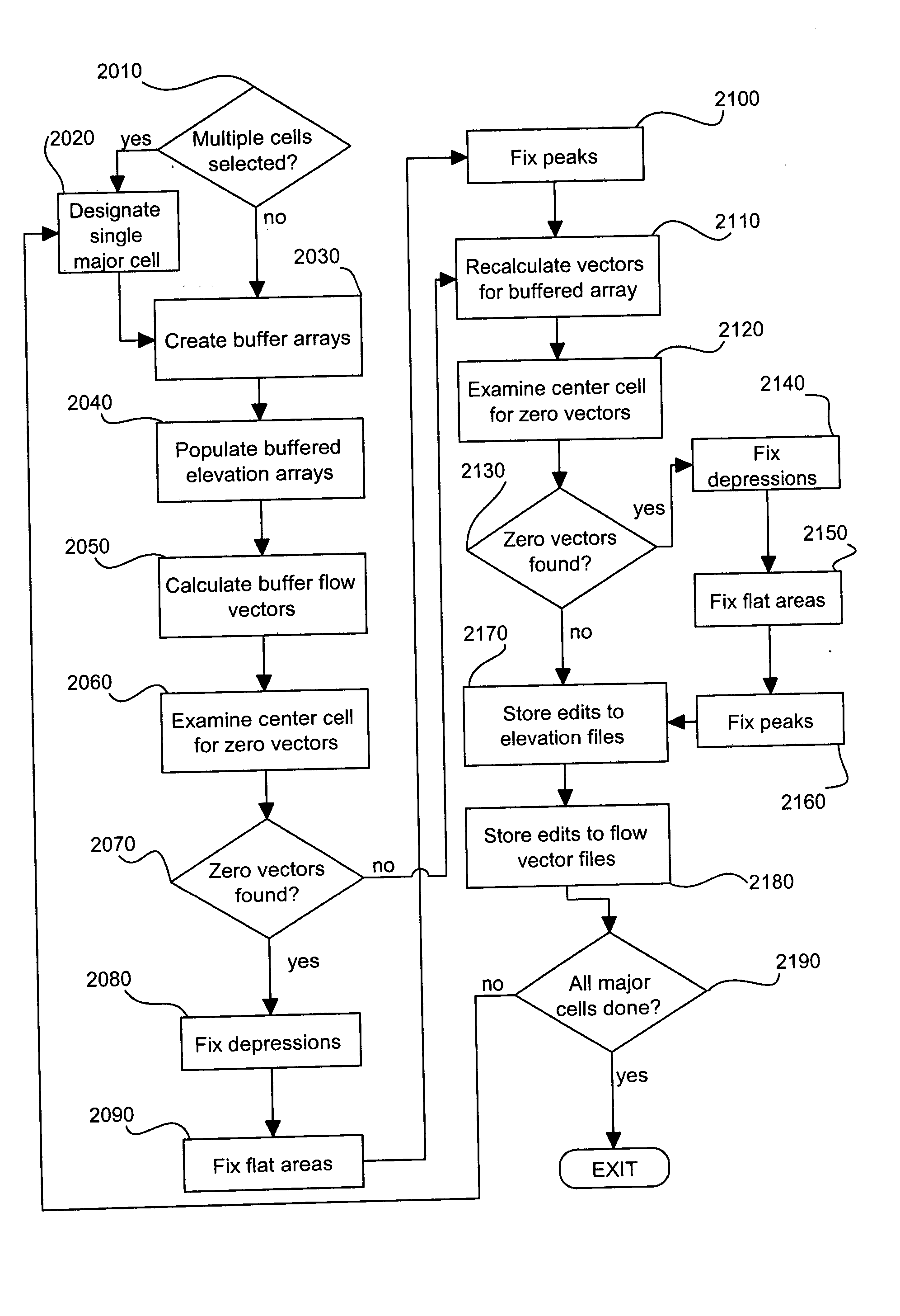
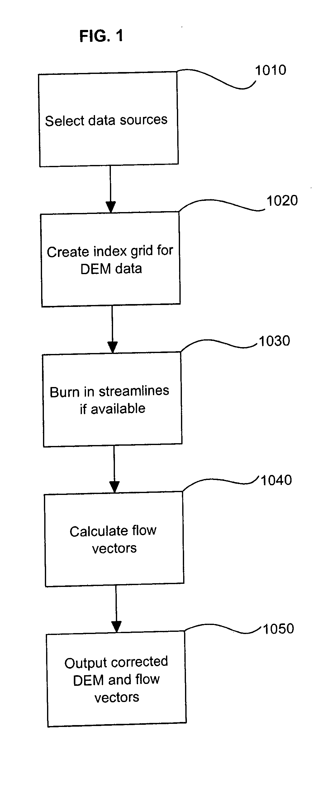
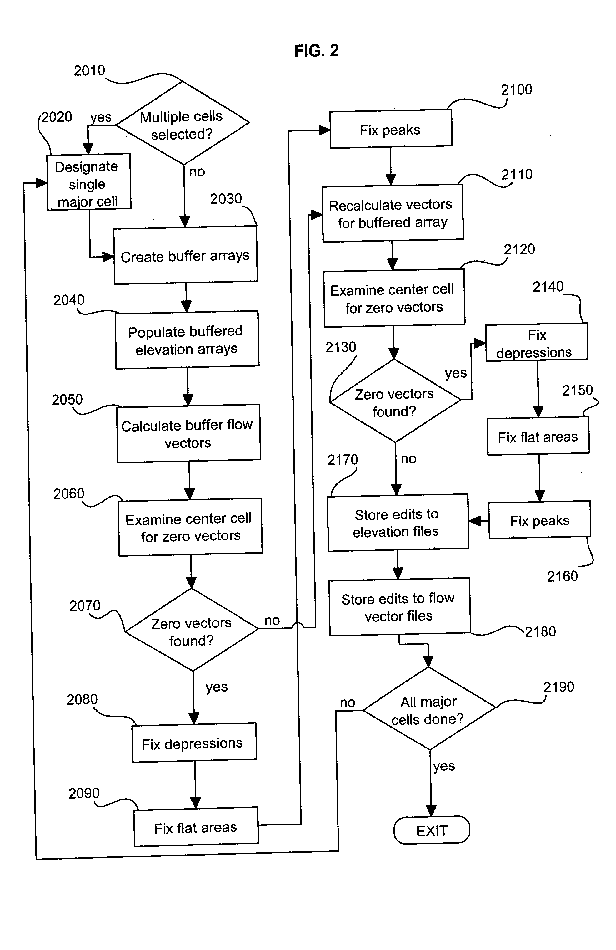
[0035] The method of this invention uses data derived from geological Digital Elevation Models (DEM's) to generate flow vectors based on a flow analysis utilizing cell elevation topology and is hereinafter referred to as FAUCET. The method derives input data from Digital Terrain Model data (DTM) that has been used to produce Triangular Irregular Network models (TIN's) for floodplain mapping and grid-based Digital Elevation Models (DEM's) for delineating basins and generating streamlines.

[0036]FIG. 1 displays a general overview of a hydrological modeling process in which the method of this invention may be used. At 1010, one or more sources of terrain data is selected to provide a basis from which flow vectors will eventually be calculated, as needed. At 1020, the user creates an index shapefile containing numerous index cells that represent the DEM data being processed. An index cell is one that is uniform in size and conforms to the extents of the DEM data source. Such index cells...


PUM


Abstract

A method for generating hydrologically correct flow vectors based on elevation data in a watershed which includes any one or more of depressions, flat areas and peaks. The watershed is typically divided into a plurality of major cells each of which encompasses a plurality of minor cells, and a user selects one or more major cells for which flow vectors are desired. Flow vectors are then calculated pursuant to the D8 method and assigned to those minor cells in the selected major cell and in surrounding major cells for which an optimal D8 solution is possible. The remaining minor cells are designated as zero vector cells and include those cells located in the problem areas. The method then generates flow vectors for minor cells in all depressions, flat areas and peaks, in that order, which exist in the selected major cells.

Description

COMPUTER PROGRAM LISTING APPENDIX [0001] This nonprovisional patent application is submitted with two copies of a compact disc meeting the requirements of 37 C.F.R. § 1.52(e)(5). This computer program listing appendix is specifically, fully incorporated herein by reference. The files appearing on the compact disc are those listed on the transmittal paper accompanying the disc. TECHNICAL FIELD [0002] The subject invention relates generally to a method and system for determining water flow directions in a watershed given a gridded array of digital elevation data. In particular, this method uses gridded elevation data to generate flow vectors indicating optimal flowpaths through depressions, flat areas and peaks occurring in the watershed. BACKGROUND OF THE INVENTION [0003] Advances in terrain data collection have spurred the need for new tools to work with this data to provide reliable, precise hydrologic and hydraulic models. More accurate sources are making new types of data with la...

Claims


Application Information

Patent Timeline
Patent Type & Authority Applications(United States)
IPC IPC(8): G01F1/00G01F7/00G01P5/00G06F19/00
CPCG01P5/001
Inventor MINTON, JOSEPH GRAYSON JR.
Owner HAYES SEAY MATTERN & MATTERN
Why Eureka
Try Eureka