Method for the synthesis of a 3D intervisibility image

a technology of intervisibility and image, applied in the direction of navigation instruments, instruments, maps/plans/charts, etc., can solve the problems of loss of certain pieces of information, difficult or even impossible for the aircraft pilot to read the information conveyed, and not always enabling the pilot to view it properly, so as to achieve the effect of improving the flight safety of the aircra

Inactive Publication Date: 2005-03-10
THALES SA
View PDF15 Cites 17 Cited by
  • Summary
  • Abstract
  • Description
  • Claims
  • Application Information

AI Technical Summary

Benefits of technology

It is the object of the invention to overcome these different drawbacks and present the pilot with the areas of intervisibility in a more ergonomic way, enabling the pilot to have sure knowledge firstly of whether the aircraft is in an area of intervisibility and secondly of when the aircraft is outside an area of intervisibility, and to know the margin of altitude remaining before the aircraft penetrates the area of intervisibility. The flight safety of the aircraft is thus substantially improved.

Problems solved by technology

Thus this prior art patent leads to the loss of certain pieces of information such as shading information representing the relief of the terrain for example, in the parts of the map covered by rays.
For the parts of the map that are in the areas of intervisibility of several threats, possibly of a different type, it becomes difficult or even impossible for the aircraft pilot to read the information conveyed by the map covered by the interlacing of the rays.
Besides, the area within range is indicated only by its boundary, which does not always enable the pilot to view it properly it in its totality.
However, these methods still have certain drawbacks.
Similarly, it is fairly difficult for him to define the path that he must take in order to remain in complete safety, outside or below the area of intervisibility.

Method used


Image

  • Method for the synthesis of a 3D intervisibility image
  • Method for the synthesis of a 3D intervisibility image
  • Method for the synthesis of a 3D intervisibility image

Examples


Embodiment Construction

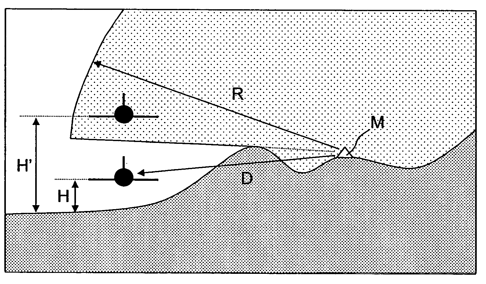
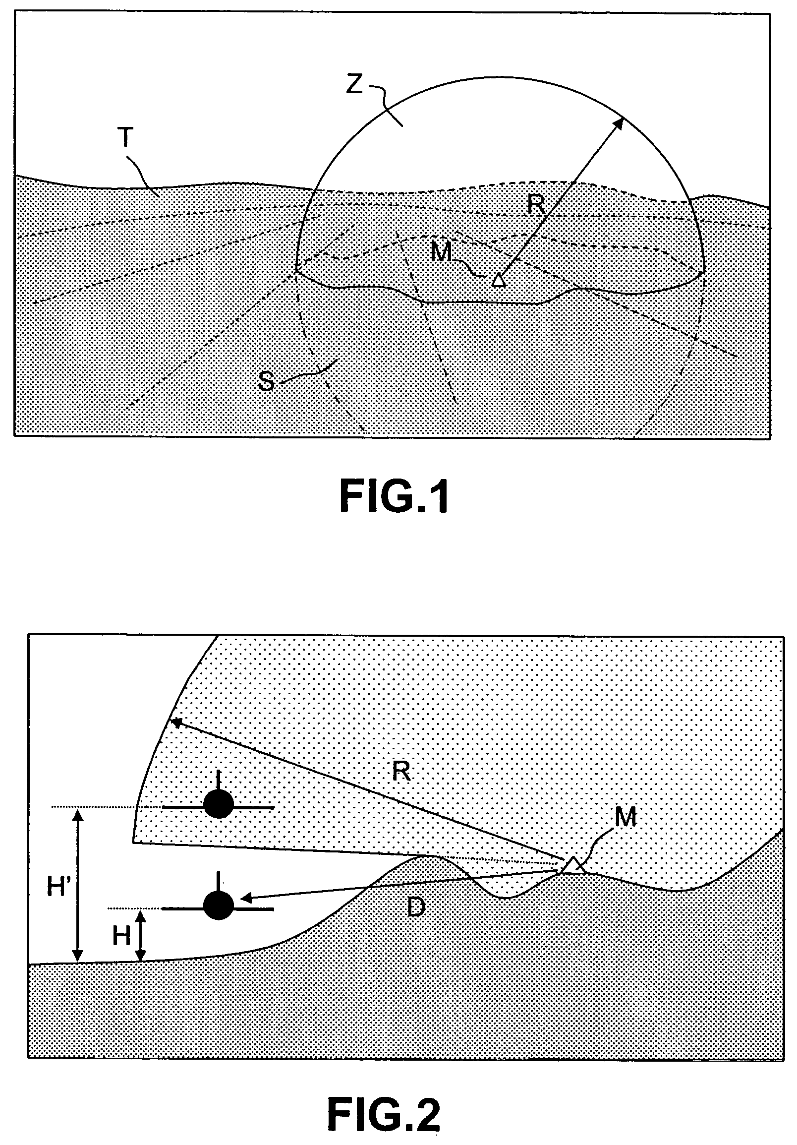
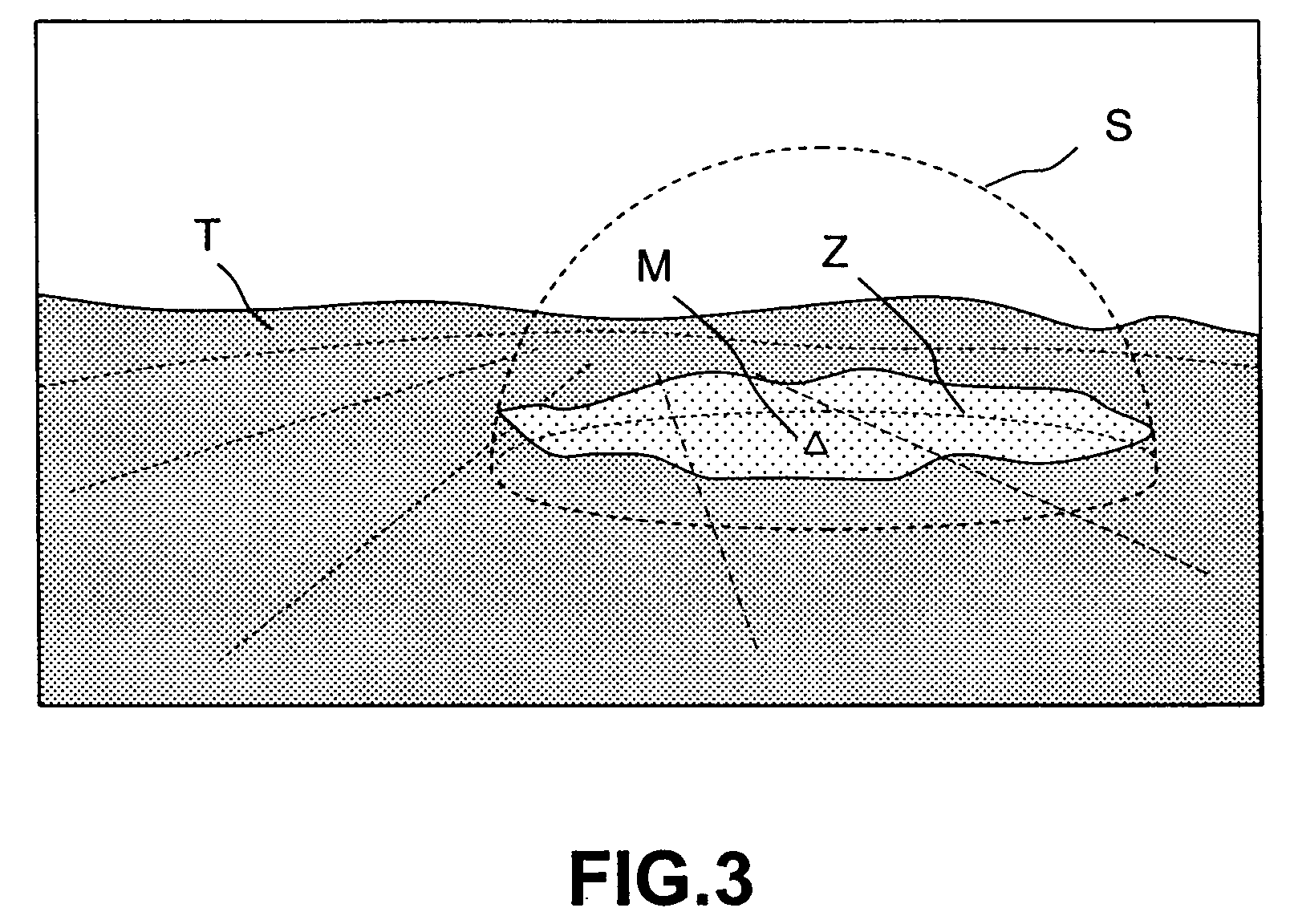
FIG. 3 shows a general 3D view of a terrain T comprising a threat M. The representation of the area of intervisibility Z according to the invention comprises only the surface layer constituted by the points belonging to the lower surface of the area of intervisibility, such that the distance from each point of the surface layer to the point of the terrain having the same geographic coordinates is as small as possible. When the aircraft is inside the sphere corresponding to the range but in an area located between the terrain and the surface layer, it is sheltered from the threat. As a consequence, the interpretation of the area of intervisibility is considerably simplified. Either the aircraft is located above the surface layer, in which case said aircraft is perceived by the threat and is in the area of intervisibility or the aircraft is located beneath the surface layer, in which case the aircraft is not perceived by the threat and is situated outside the area of intervisibility. ...


PUM


Abstract

The field of the invention is that of methods for the synthesis of a 3D mapping image consisting of pixels and representing the distribution of the intervisibility area on a terrain overflown by an aircraft. An intervisibility area is understood to mean the area within range of a known potential threat. The method of the invention represents the intervisibility area in the form of the surface layer constituted by points belonging to the sphere covered by the threat, such that the distance from each point of the surface layer to the point of the terrain having the same geographical coordinates should be as small as possible. This arrangement enables the aircraft pilot to have very clear and very easily interpretable information available to him. Furthermore, the method requires limited computation resources. This facilitates its implementation in onboard mapping generators.

Description

BACKGROUND OF THE INVENTION 1. Field of the Invention The field of the invention is that of methods for the synthesis of mapping images formed by pixels and representing the distribution of the intervisibility zones or areas on a terrain overflown by an aircraft. An intervisibility area Z is an area within range of a known potential threat. If the threat M has a radius of range R, then this range is a portion of a sphere S bounded in its lower part by the relief of the terrain T in which the threat is located, as indicated in FIG. 1. FIG. 2 shows that, depending on terrain relief features, there are areas which, although they are located at a distance D smaller than the radius of range R, are not in the area of intervisibility of the threat M. As a consequence, the presence or absence of an aircraft in the area of intervisibility of a threat will depend not only on its geographical position but also on its altitude. For example, in FIG. 2, the aircraft A is outside the area of in...

Claims


Application Information

Patent Timeline
Patent Type & Authority Applications(United States)
IPC IPC(8): G09B29/00G01C21/00G06T15/10
CPCG01C21/005G06T17/05G06T15/10
Inventor SERVANTIE, XAVIER
Owner THALES SA
Why Eureka
Try Eureka