Graphic airways displays for flight management systems

a flight management system and flight path technology, applied in the field of aircraft flight path displays and aircraft flight management systems, can solve the problems of increasing process burden, cluttered display, and difficult for flight crews to find navigational information

Active Publication Date: 2005-06-23
HONEYWELL INT INC
View PDF10 Cites 45 Cited by
  • Summary
  • Abstract
  • Description
  • Claims
  • Application Information

AI Technical Summary

Benefits of technology

[0007] An apparatus is provided for interactively building flight paths for entry into an aircraft flight management system (FMS). The apparatus comprises a database containing map information, a display for presenting the map information, a user controlled cursor and selection buttons, all under the control of a graphics processor coupled to the FMS. The processor presents the map information with included navigation features on the display. These are correlated with the aircraft position and cursor location. When the cur...

Problems solved by technology

At larger ranges the display can become very cluttered and can be difficult for the flight crew to find the navigational information of interest.
Further, prior art displays are generally static, that is the display may not change unless the range setting or aircraft location changes.
This process can become increasingly...

Method used


Image

  • Graphic airways displays for flight management systems
  • Graphic airways displays for flight management systems
  • Graphic airways displays for flight management systems

Examples


first embodiment

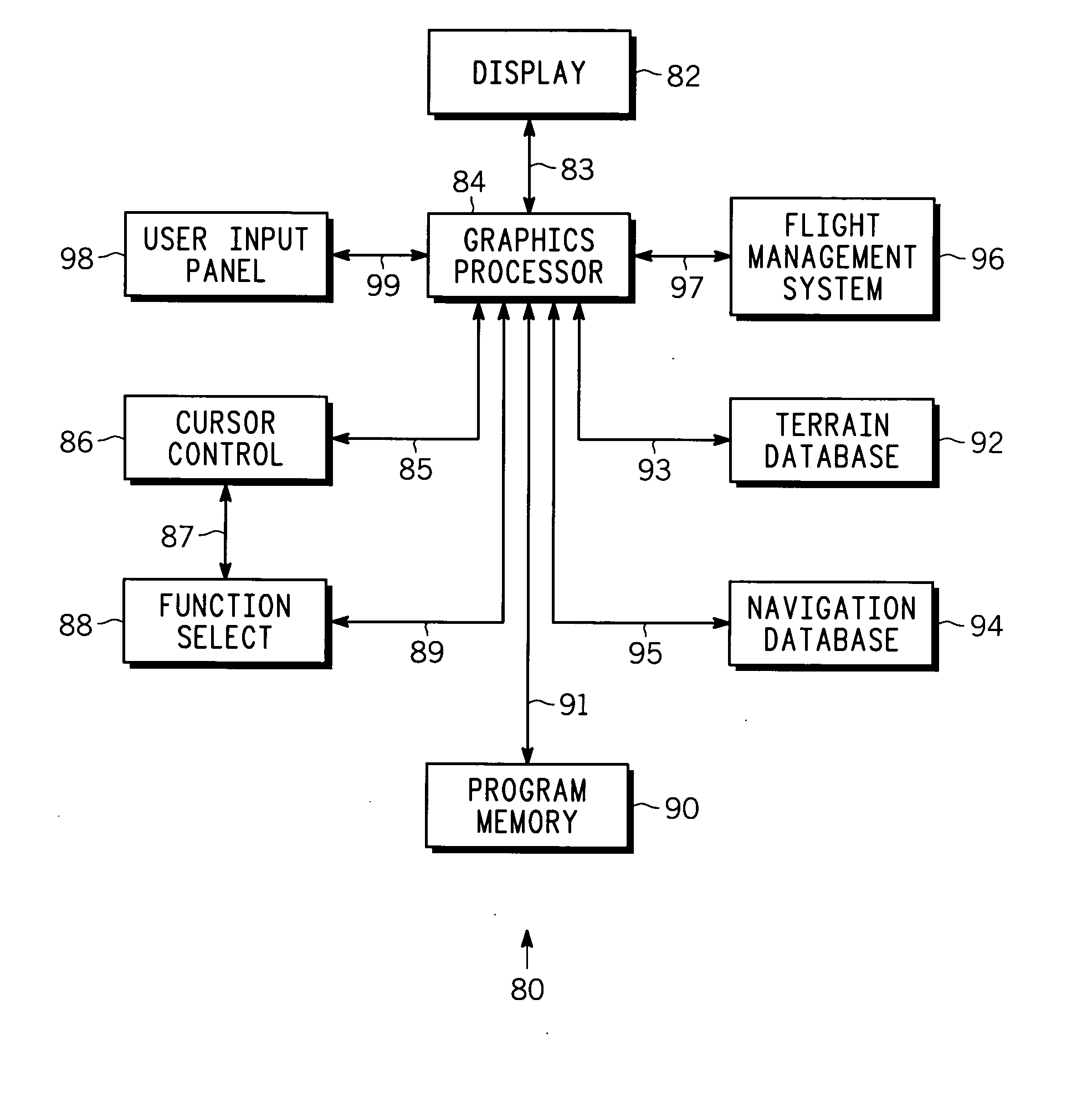
[0033]FIG. 7 is a simplified flow chart of method 100 of the present invention according to a Method 100 begins with START 102, which preferably occurs on system start-up. In step 104 the map settings (e.g., range, color, orientation, etc.) are obtained depending upon what the user has set into input panel 98. In step 106, processor 84 determines the displayable map area, that is, given the finite dimensions of screen 82 and the range selected by the user, processor 84 determines what terrain and navigation area can be shown on display 82. In step 108, the terrain and navigational features information stored in memories 92, 94 is retrieved for the map area determined in step 106 and sent to display 82. In general, it is convenient to place the aircraft present location at the center of the screen, but this is not essential. The present aircraft location is conveniently provided by FMS 96 but this is not essential. Any means of obtaining the current aircraft position may be used. (A...

second embodiment

[0036]FIG. 8 is a simplified flow chart of method 200 of the present invention and showing further details. In method 200 it is assumed for convenience of explanation that the navigational feature initially highlighted by the cursor is an airway and that route planning is being accomplished by selecting waypoints. Following START 202, which conveniently occurs on system start-up, steps 104 through110 described in connection with FIG. 7 are executed leading to query 212, wherein it is determined whether or not cursor 24 is on an airway path or navigational feature. Query 212 is analogous to query 112. If the outcome of query 212 is NO (FALSE) then as shown by path 213, query 212 is repeated. If the outcome of query 212 is YES (TRUE) then step 214 is desirably executed wherein the airway path on which cursor 24 rests is highlighted as previously described. Step 214 is analogous in part to step 114. Query 216 is then executed wherein it is determined whether or not the highlighted air...


PUM


Abstract

Methods and apparatus are provided for interactively building flight paths for entry into an aircraft flight management system (FMS). The apparatus comprises a database containing map information, a display for presenting the map information, a user controlled cursor and selection buttons, all under the control of a graphics processor. The processor presents the map information with included navigation features on the display, correlated with the aircraft position and cursor location. When the cursor overlies a navigational feature (airways, waypoints, etc.), the processor highlights the feature. Feature ID information may also pop up when the feature is highlighted. Using a mouse button or equivalent, the user selects the highlighted feature or ID, whereupon the processor sends the information associated therewith to the FMS. By successively highlighting and selecting features or IDs an entire flight path can be identified and entered automatically into the FMS without the need for individual text entry.

Description

TECHNICAL FIELD [0001] The present invention generally relates to displays for a vehicle, and more particularly, to aircraft flight path displays for use in connection with an aircraft flight management system. BACKGROUND [0002] Modem map displays, particularly those used in aircraft for flight planning and management, are capable of displaying a considerable amount of information such as flight navigation planning information and terrain information. The terrain information generally consists of situational awareness information (obstacles, landmarks, etc.) and warnings that, among other things, may indicate where the aircraft may potentially impact such terrain features may be in the aircraft's flight path. The flight planning and navigation information generally consists of flight path, altitude and other information useful to the flight crew in planning and following a particular path (and altitude) of the aircraft over the ground to reach a desired destination. Available “airwa...

Claims


Application Information

Patent Timeline
IPC IPC(8): B64D43/00G01C23/00G06F3/023
CPCG01C23/005
Inventor HE, GANGWILSON, BLAKE W. JR.SUDDRETH, JOHN G.GAMEROS, CARLOS M.DANIEL, PETER L.
Owner HONEYWELL INT INC
Why Eureka
Try Eureka