System and method for updating, enhancing, or refining a geographic database using feedback

a geographic database and feedback technology, applied in traffic control systems, navigation instruments, instruments, etc., can solve problems such as inaccurate data difficulty in maintaining up-to-date information in the geographic data set, and outdated geographic information, etc., to achieve high levels of confiden

Inactive Publication Date: 2005-07-07
HERE GLOBAL BV
View PDF56 Cites 114 Cited by
  • Summary
  • Abstract
  • Description
  • Claims
  • Application Information

AI Technical Summary

Benefits of technology

[0017] In yet still another aspect of the invention, using a feedback process, levels of confidence of accuracy are assigned to data in the geographic database representing physical features in the geographic region, thereby enabling the data to be used for purposes requiring high levels of confidence.

Problems solved by technology

One potential obstacle to providing enhanced features with a navigation system is the difficulty in maintaining up-to-date information in the geographic data set.
Geographic information, however, becomes outdated as new roads are built, existing roads are changed, traffic signals are installed, businesses change their hours of operation, new businesses open, existing businesses close, etc.
When changes occur, data in the geographic data set becomes inaccurate and its utility is thereby lessened.
However, the process of acquiring information regarding changes is time-consuming and expensive.
Moreover, existing methods of acquiring updated data may become increasingly expensive as geographic databases become more detailed and extensive in scope.
Another limitation with existing methods of data acquisition is accuracy.
Even with high quality aerial photographs and other existing collection methods, the geographic coordinates of features may not always be entered in the database with a high level of precision.

Method used


Image

  • System and method for updating, enhancing, or refining a geographic database using feedback
  • System and method for updating, enhancing, or refining a geographic database using feedback
  • System and method for updating, enhancing, or refining a geographic database using feedback

Examples


Embodiment Construction

[0031] I. System Overview

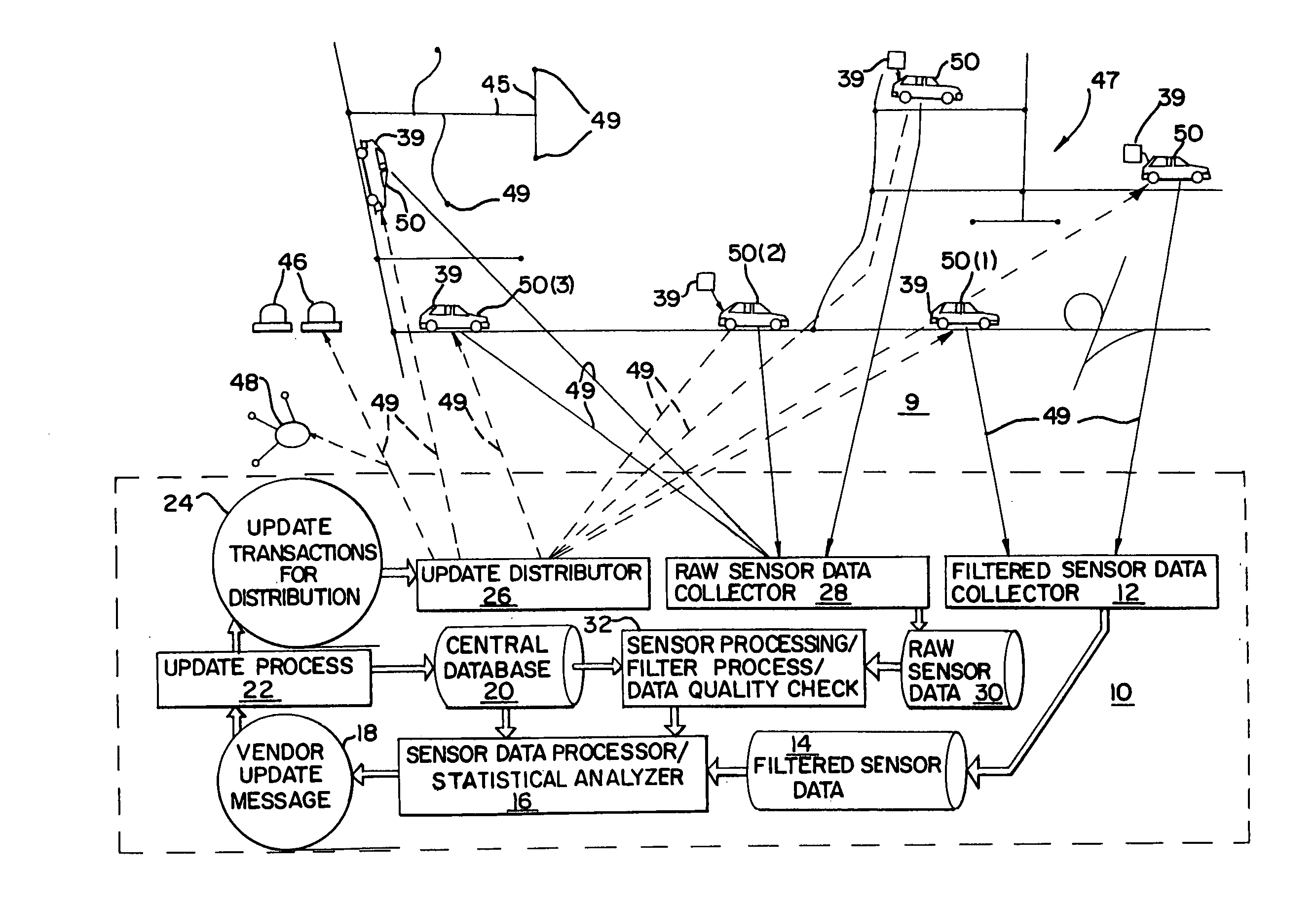
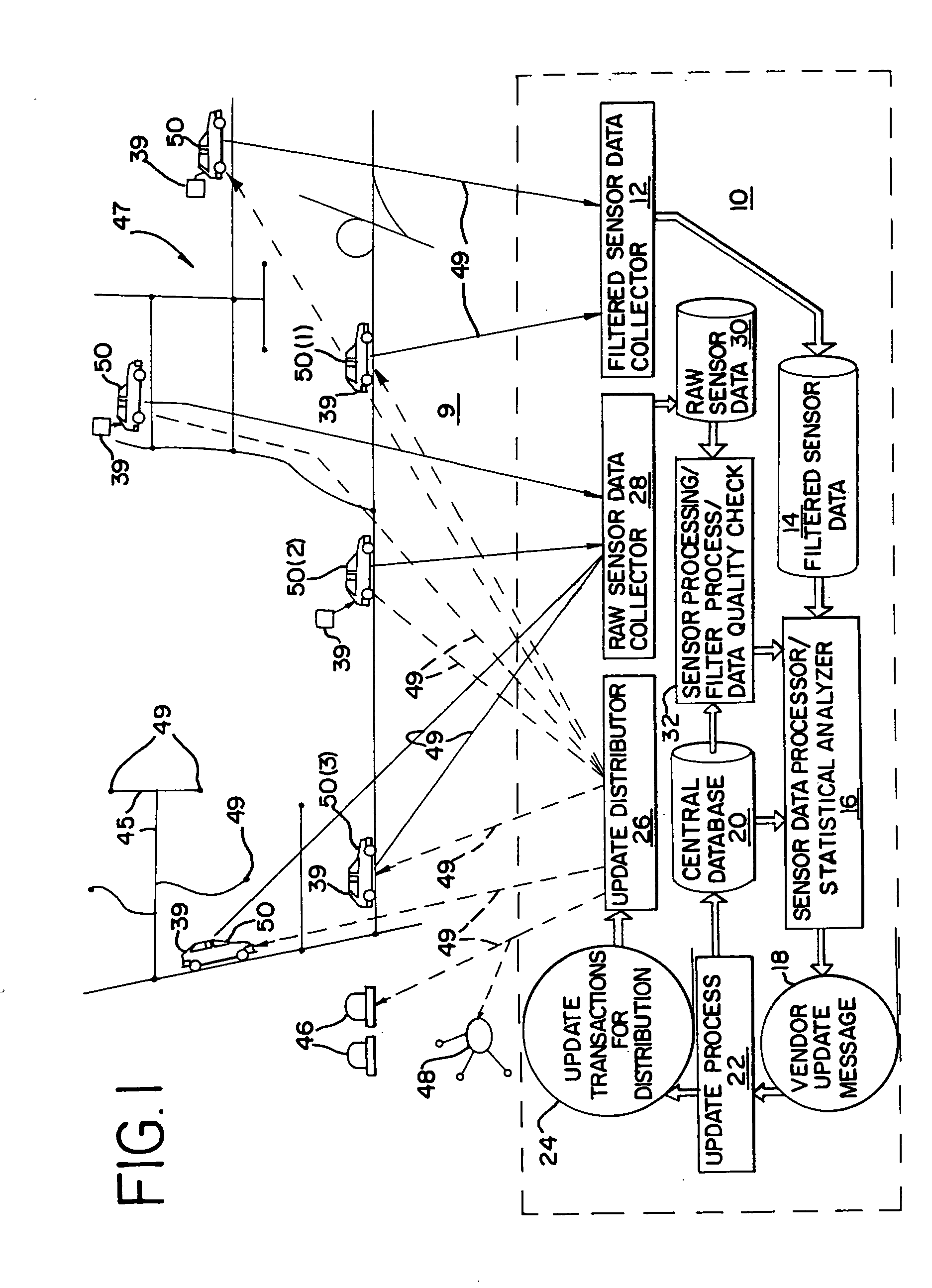
[0032] Referring to FIG. 1, a system 9 for updating and enhancing a geographic database includes a central geographic data manager 10. The central geographic data manager 10 includes a central geographic database 20. The geographic database 20 includes data that represents physical features in a geographical area 47. The central geographic database 20 may include data descriptive of position data in terms of points 44 on the map and of links, or segments of roads 45. The central geographic database 20 may also include data representing road gradients, road widths, lane widths and shoulder widths, and data that is descriptive of stationary objects such as stop signs, buildings, bridge supports, etc. The central geographic database 20 may include non-positional features such as speed limits, the direction of travel allowed on the roads and the directions of allowed turns. The central geographic database 20 may include other types of information as well, for e...


PUM


Abstract

A method for updating a geographic database is disclosed. Data collecting equipment is installed in each of a plurality of vehicles each of which also has a navigation system. The data collection equipment is used to collect data while the vehicles are being driven along roads by their respective users. In addition, a method for assigning a confidence level to geographic data is disclosed. The confidence level is assigned to the geographic data as an attribute. In addition, a method for determining a position of a vehicle by sensing roadside structures is disclosed. Data indicating positions of roadside structures are contained in a geographic database. By matching positions of sensed roadside structures to data in the geographic database that indicates the positions of the structures, the position of the vehicle while traveling can be determined.

Description

REFERENCE TO RELATED APPLICATION [0001] The present application is a continuation of Ser. No. 10 / 298,798, filed Nov. 18, 2002, which was a continuation of Ser. No. 09 / 532,751 filed Mar. 22, 2000, now U.S. Pat. No. 6,516,267, which was a continuation of Ser. No. 08 / 951,767, filed Oct. 16, 1997, now U.S. Pat. No. 6,047,234.BACKGROUND OF THE INVENTION [0002] The present invention relates to a system and method for updating and enhancing a geographic database, and more particularly, the present invention relates to a system and method for updating and enhancing a geographic database based on feedback from field use of the geographic data. [0003] Computer-based navigation systems for use on land have become available in a variety of forms and for a variety of applications. One exemplary type of system uses a geographic data set, a navigation application, and optionally, a positioning system. The geographic data set includes information about the positions of roads and intersections in or...

Claims


Application Information

Patent Timeline
Patent Type & Authority Applications(United States)
IPC IPC(8): G09B29/00G01C21/26G06F17/30G08G1/09G08G1/0969
CPCG01C21/26G08G1/0969G01C21/32G01C21/3841G01C21/3819G01C21/3811G01C21/3848G01C21/3822
Inventor CHERVENY, KEVINCRANE, AARONKAPLAN, LAWRENCE M.JASPER, JOHNSHIELDS, RUSSELL
Owner HERE GLOBAL BV
Why Eureka
Try Eureka