Method and apparatus for creating and maintaining a GIS

Inactive Publication Date: 2005-07-07
JUNGLE LASERS
View PDF6 Cites 53 Cited by
  • Summary
  • Abstract
  • Description
  • Claims
  • Application Information

AI Technical Summary

Problems solved by technology

This is a materials and human resource planning problem about which insights can be gained through use of a GIS.
For example, a bridge that is funded with federal monies has an expected useful life, requires periodic maintenance and is affected by degrading factors and events such as car impacts and weather.
While a GIS is a desirable tool for the management of geographically related assets, it has not been in common use by municipal government to-date.
Barriers to its successful use include high initial costs for system design and implementation, data input, staff training, staff inertia, management shortcomings, and software and hardware requir

Method used


Image

  • Method and apparatus for creating and maintaining a GIS
  • Method and apparatus for creating and maintaining a GIS
  • Method and apparatus for creating and maintaining a GIS

Examples


Embodiment Construction

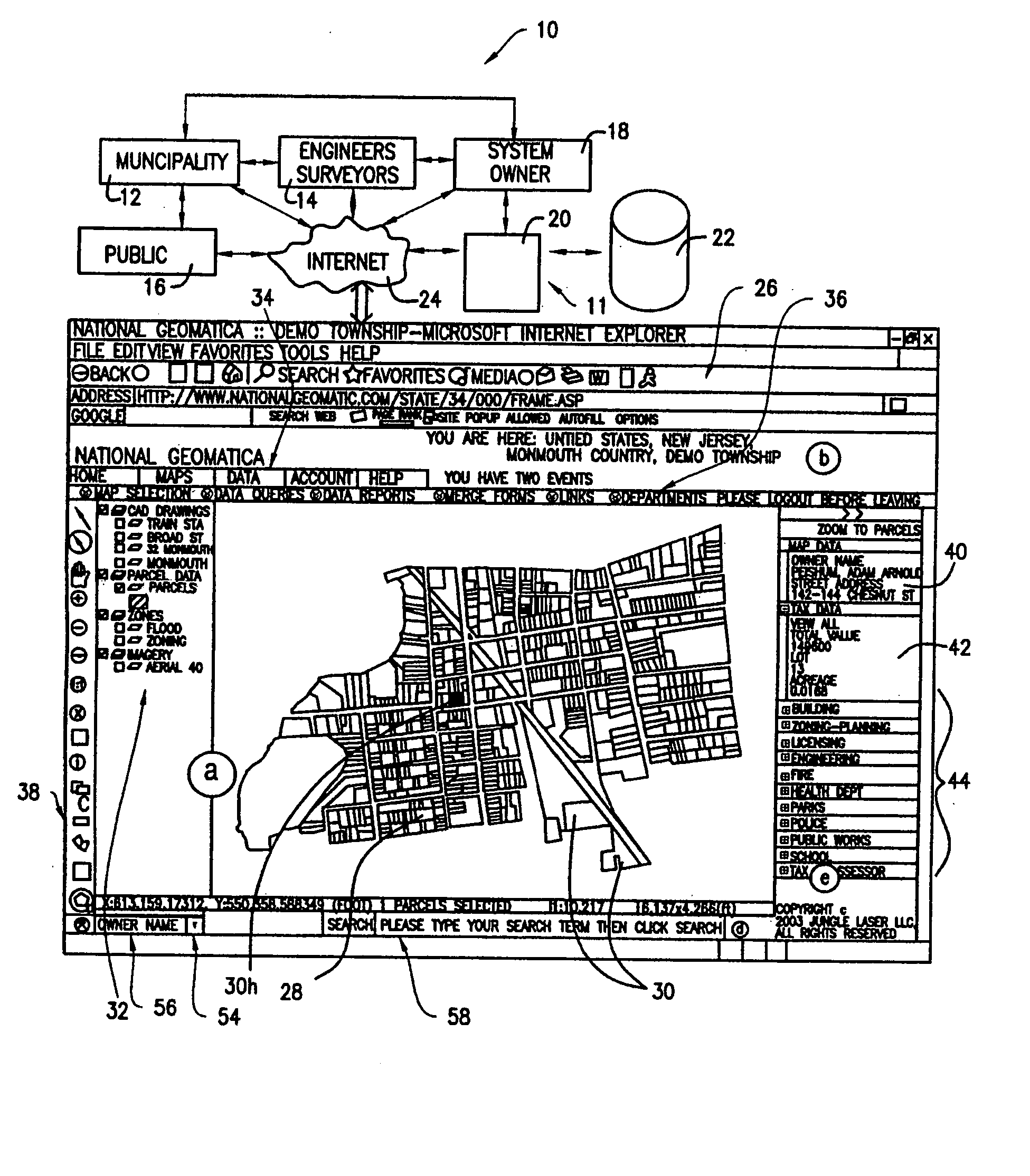
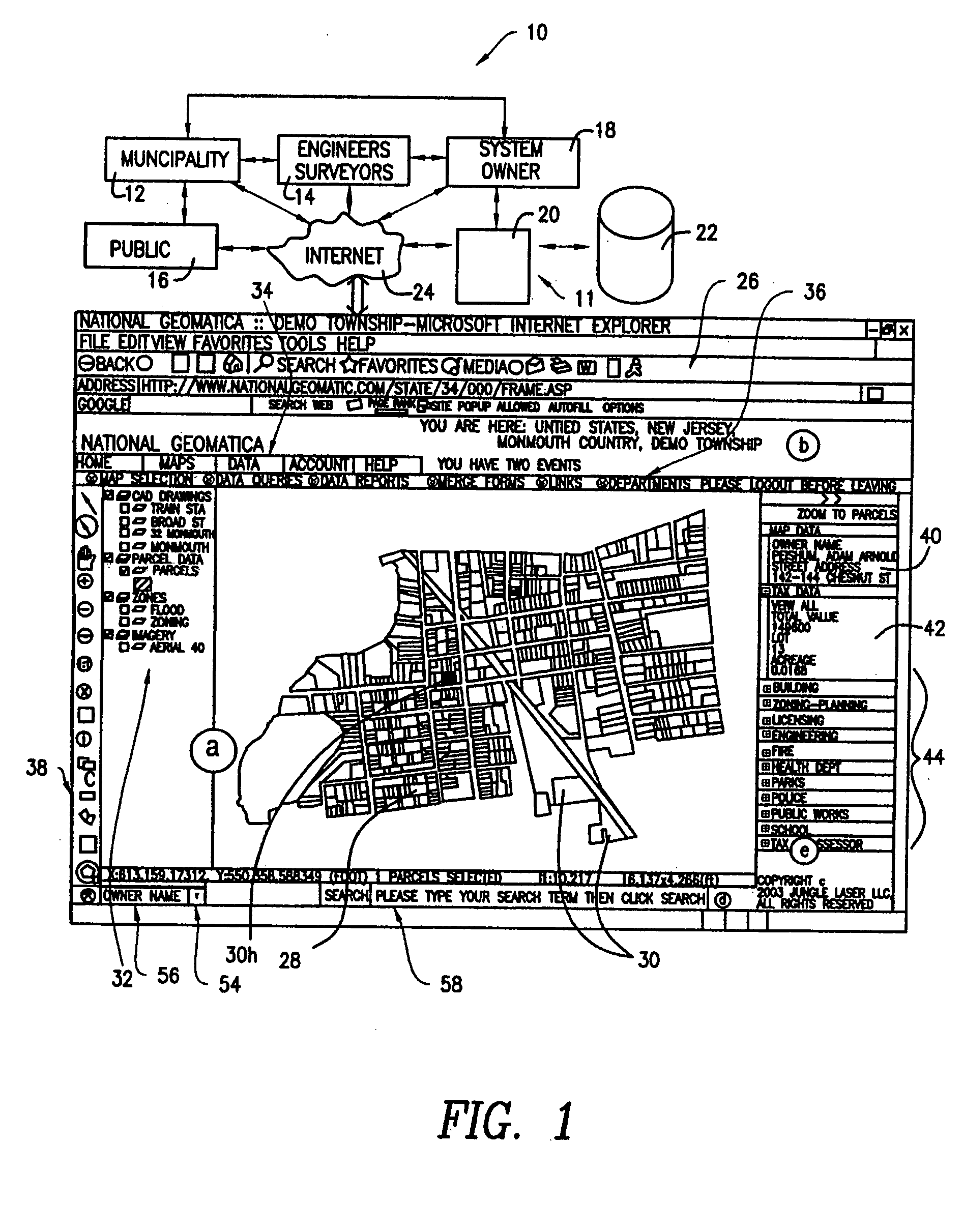
[0013]FIG. 1 shows a system 10 in accordance with the present invention, which incorporates and coordinates the capabilities and functions of federal, state and local governmental entities (hereinafter “municipalities”) 12, civil engineers and surveyors or anyone else with expertise in GIS's, such as architects, planners, GIS firms, geographers, cartographers and consultants (hereinafter “engineers”) 14, the public 16 and the system owner 18 to produce, fund, use and maintain a GIS 11 to the service and benefit of all parties. As shall be explained fully below, the system owner 18 assembles a hardware / software system 20 which stores and retrieves geographically related data obtained from municipalities 12, engineers 14 and the public 16 in a database 22. The data from the database 22 is then modeled as a GIS presented over the Internet 24 to authorized users, including the municipalities 12, the engineers 14 and the public 16. An exemplary screen display 26 in accordance with the pr...


PUM


Abstract

A system for presenting a GIS and method for making and using one includes the necessary hardware and software for presenting a GIS over the Internet. The GIS is particularly useful for municipalities and has an interactive, searchable database containing map data and parcel related data, such as tax records and information useful to various departments in a town, such as the police and building licensing departments. A server computer running GIS software presents the map data and the parcel related data to town users over the Internet. The system includes means for updating the related data by utilizing a system where towns fax forms to the system which converts them to image files from which relevant data fields are extracted and evaluated by optical character recognition. To fund the establishment, use and maintenance of the system, citizens are charged fees for submitting data change transactions, i.e., when forms, such as a building application are submitted to the towns. Civil engineers participate in the system by, inter alia, buying licenses to use and market the system to towns, teaching the towns how to use the system, preparing and maintaining maps and otherwise functioning as technical experts mediating between the towns and the system owner.

Description

FIELD OF THE INVENTION [0001] The present invention relates to apparatus and methods for creating, marketing, implementing, using and maintaining a data processing system utilizing a map interface, commonly known as a Geographic Information System (GIS). More particularly, the GIS is available to authorized users, such as municipalities, over the Internet. BACKGROUND OF THE INVENTION [0002] GIS's are known and used as a tool to model and depict place-related information on a geographic map displayed on a computer screen. Of course, the information displayed on the screen can be printed out or otherwise stored and / or communicated, e.g., in a file that can be transmitted over the Internet. The map display typically acts as a graphical user interface whereby data associated with a particular location on the map can be accessed by “clicking-on” the location on a computer mouse. When a specific location is “clicked-on”, this causes the data associated with that location to be displayed o...

Claims


Application Information

Patent Timeline
IPC IPC(8): G06F7/00G06F17/30
CPCG06F17/30241G06F16/29
Inventor HODNETT, RAYMOND J.GARFINKEL, DEAN S.CATANESE, MARKRYSTROM, ALEX
Owner JUNGLE LASERS
Why Eureka
Try Eureka