The collection and
processing of geophysical data is a massive and costly effort.
Marine data collection, typically done by private boat operators in accordance with business relationships described below, is
time consuming and expensive.
This cost does not include marketing and equipment deployment costs, which can add substantially to the data collection costs.
Seismic surveys are the first in a series of costly and time-consuming exploratory efforts undertaken prior to drilling for the production of gas and oil.
If the results of a
seismic survey appear promising, then exploratory drilling may be performed, typically through the use of expensive boat-based technology to explore deep-
water resources.
Such an infrastructure is extraordinarily expensive to both construct and operate.
It will thus be seen that the collection, review and analysis of seismic data comprises the first in an expensive and long-term series of exploration, drilling and production activities.
Dated, corrupt or otherwise faulty or inadequate seismic data could initiate a chain of events that would waste significant amounts of money and result in the loss of valuable alternate opportunities.
Despite the value and importance of geophysical data, the existing market for collecting, updating and marketing such data is not an efficient one.
If the seismic company is unsuccessful, they may loose a great deal of money on the
shoot.
In fact, E&P companies may be reluctant to provide too much guidance because E&P company information may be considered
trade secret.
Thus, while speculative
shoot data may be of value, it may not cover the most important area or include the most desirable
shoot parameters for any single E&P customer.
This type of data collection model is thus risky for the seismic company and not necessarily most efficient for a given E&P company.
This model of geophysical data collection shifts much of the risk from the seismic company to the E&P company.
However, the cost to the E&P company is very high.
If the data turns out to be of a lower value than expected, the E&P company will have suffered a significant financial loss.
Further, the company will have wasted a significant portion of an allocated seismic budget, thereby reducing opportunities to consider and explore alternate opportunities.
Ultimately, multiple failed opportunities could challenge an E&P company's ability to plan the development and profitable deployment of long-term drilling and production resources.
While superficially a multi-
client shoot appears to be one of the most cost-effective types of shoots, it is not without its own significant challenges and risks.
Assembling a multi-
client shoot is difficult and expensive.
Matching the needs of multiple E&P clients with the capability of the seismic company can take a long period of time and significant expense.
If the seismic company fails to assemble the multi-
client shoot, the will suffer a business loss.
Logistical costs, administrative costs, broker costs, the cost of accidental or convenience-driven overshoots, can all affect the cost and profitability of a shoot.
It will thus be understood that seismic data collection today, particularly boat operation, can be a risky and inefficient business.
The lack of predictable demand results in the taking of speculative shoots and the ad hoc marketing of these shoots.
Because it is difficult for boat owners to predict future demand, they cannot easily determine where to efficiently locate boats.
From a consideration of the above, it will be understood that despite the importance of geophysical data to the development of world energy needs, the processes for collecting such data are not very efficient.
As will now be explained, the current models for managing and distributing collected geophysical data are not in and of themselves efficient, either.
In fact, because of the
processing issues associated with collecting and distributing data, collected data is likely to be copied to multiple locations, including the original collector, the end-user and often a facilitating intermediary.
However, licensing or reselling data is often difficult for a variety of legal and logistical reasons.
As a result of transmission, storage and processing, the quality of the data may be questionable.
Data sets may be so large that it becomes inefficient if not impossible to sort them, identify their contents and distribute them to potential new users.
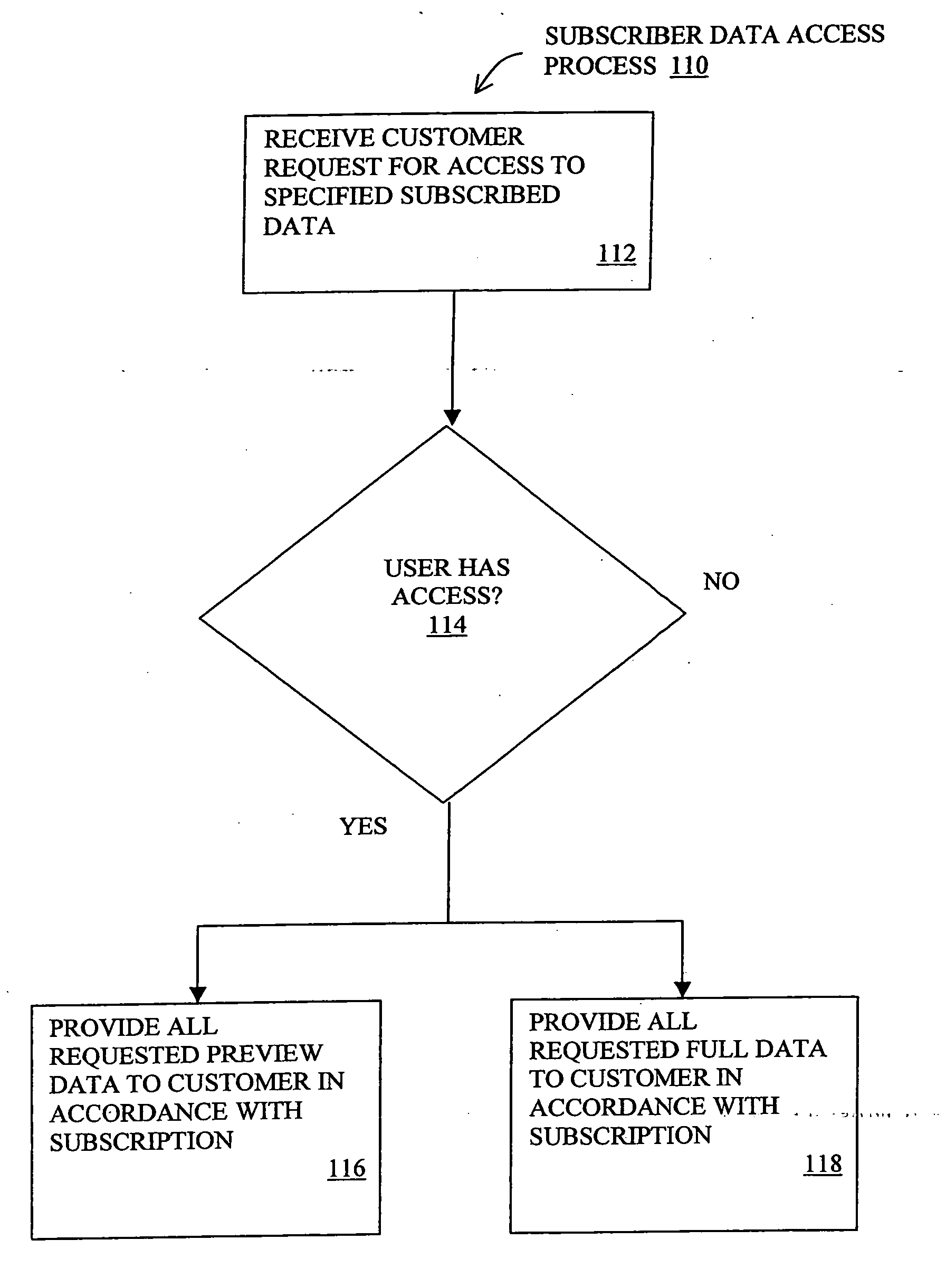
Because of the high costs of even ‘used’ data, a typical licensing structure may include providing access to ‘peek’ data at a first, less expensive cost, followed by access to
full data at a second, higher cost.
However, because of the size of the data sets, this type of tiered data distribution creates technical challenges in addition to all of the issues described above.
However, the mere collection and brokering of seismic data does not address, much less solve, many of the problems outlined above.
It is thus seen that there exists huge quantities of costly, collected geophysical data having potentially significant value to various users above and beyond those who sponsored the initial collections.
However, significant problems exist with organizing, identifying, maintaining the integrity of and distributing such data to potential users.
As described above there are significant challenges associated with efficiently selecting, collecting and distributing new data.
The various interested parties often find today's methodologies inefficient and costly.
Boat owners are faced with unorganized, unpredictable demand that makes efficient boat placement and operation challenging if not impossible.
E&P companies face huge expenditures to get access to limited data which may be of unexpectedly low value.
However, brokering of seismic data does not address the core inefficiencies in collection and distribution described above.

