Geospatial information system and method for updating same

a geospatial information and system technology, applied in the field of system and method for updating geospatial information, can solve the problems of inefficiency, inability to sustain, and inability to update literally millions of street information using such an ad hoc method of updating, and achieve the effect of facilitating the updating of geospatial information

Inactive Publication Date: 2005-12-15
TELE ATLAS NORTH AMERICA
View PDF34 Cites 74 Cited by
  • Summary
  • Abstract
  • Description
  • Claims
  • Application Information

AI Technical Summary

Benefits of technology

[0018] Yet another advantage of the present invention is in providing a geospatial information system and method that allows customers to monitor the status of their requested changes and updates.
[0019] Another advantage of the present invention is in providing a geospatial information system and method that facilitates updating of geospatial information.
[0020] Still another advantage of the present invention is in providing a geospatial information system and method that allows updates to be effectuated in an efficient manner.
[0021] In accordance with one aspect of the present invention, a geospatial information system is provided, the system including a database adapted to store geospatial information, a processing unit in electronic communication with the database and being adapted to access and retrieve the geospatial information from the database, a tool permissions module to associate a tool permission level with a user, and a user interface module including a plurality of enhancement tools to allow a user to generate an enhancement request that requests a change to the geospatial information stored in the database, each of the plurality of enhancement tools being adapted to request a specific type of change to the geospatial information stored in the database, and being generated based on the tool permission level associated with the user so that the user is provided with a plurality of tools corresponding to the tool permission level. In accordance with one implementation, the geospatial information may be an address, street name, street direction, intersection, and / or street path, and the tool permission level associated with the user is determined based on a login identification assigned to the user.
[0022] In accordance with another aspect of the present invention, the geospatial information system includes a user interface module adapted to display a graphical map and having an enhancement tool for allowing a user to generate an enhancement request that requests a change to the geospatial information stored in the database by marking changes on the graphical map, and a monitoring module adapted to dynamically monitor a status of the enhancement request or change requested in the enhancement request and to graphically indicate the status in the graphical map using a plurality of colors that represent different status.
[0023] In accordance with yet another aspect of the present invention, the geospatial information system includes a user interface module having an enhancement tool to allow a user to generate an enhancement request that requests a change to the geospatial information stored in the database, and an audit module adapted to apply at least one logic check to determine whether the change requested in the enhancement request is consistent with other confirmed geospatial information stored in the database, and to generate an edit failure notification to the user if the change requested in the enhancement request is logically inconsistent with other confirmed geospatial information stored in the database.

Problems solved by technology

Acquisition of geospatial information for incorporation into a database by a geospatial information provider involves expenditure of significant effort and expense.
Geospatial information for any given geographical area is frequently subject to change and may, in some instances, be incorrect.
However, maintenance of literally millions of street information using such an ad hoc method of updating is not efficient and cannot be sustained without expenditure of tremendous amount of resources.
In addition, such method of updating the geospatial information is often not possible since the materials provided by the customer requesting change may not be complete and fail to specifically identify the location for which the changes to the geospatial information should be made.
As a consequence of the various noted limitations of the conventional method of updating geospatial information, entry of requested changes to update the geospatial information frequently took period of many months.
However, the method and system disclosed in Barton only provides minimum utility in the geographical data updating process in that only the submission of change requests are facilitated.
In addition, although the quality of information that is provided by the end user may vary widely depending on the end user, this variation in quality of information is not addressed by the method and system disclosed in Barton.
Moreover, even when changes are submitted in a generated report, such changes typically take time in order for it to be entered into the geographical database.
However, the method and system of Barton does not provide any mechanism for allowing end users to monitor the status of their requested changes.
Therefore, in view of the above, there still exists an unfulfilled need for an effective way for customers to convey more accurate and current geospatial information to geospatial information providers, where the quality of information provided by the customers is improved.
There also exists an unfulfilled need for a geospatial information system and method that allows customers to monitor the status of their requested changes and updates.

Method used


Image

  • Geospatial information system and method for updating same
  • Geospatial information system and method for updating same
  • Geospatial information system and method for updating same

Examples


Embodiment Construction

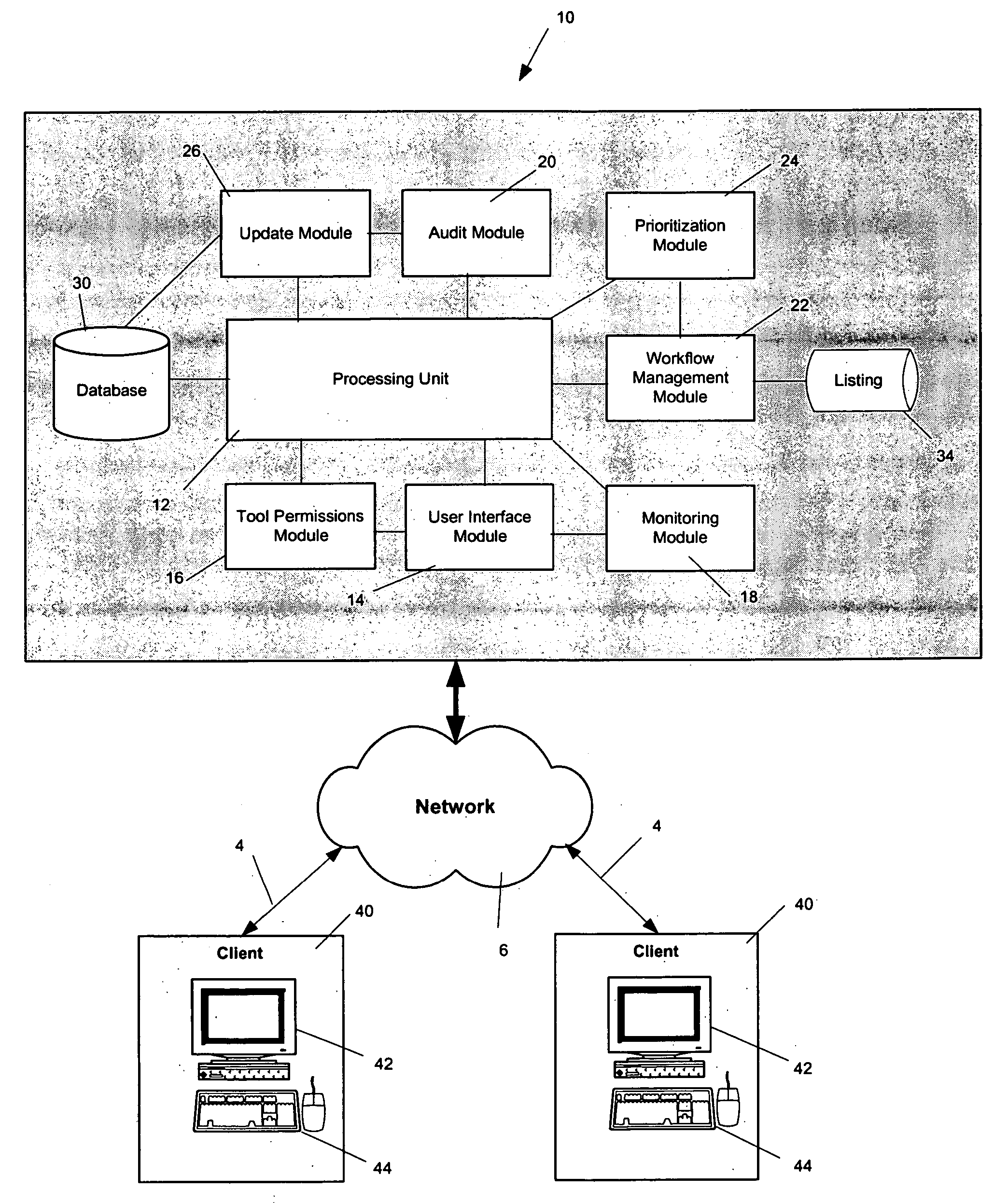
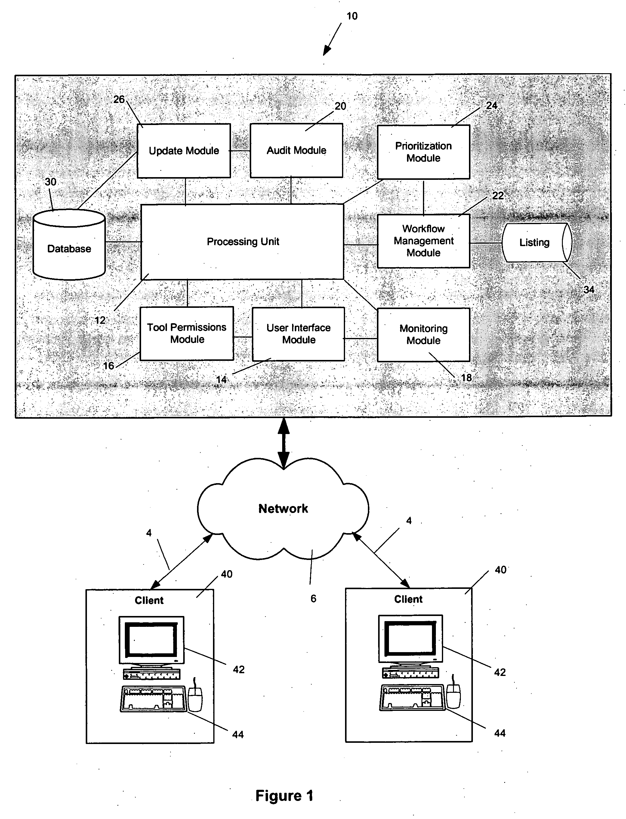
[0047] The geospatial information system 10 as shown in FIG. 1, and the method for updating geospatial information described herein below, provide an effective system and method for allowing users of the system to convey more accurate geospatial information to the administrator of the geospatial information system 10. In particular, the geospatial information system and method of the present invention facilitate updating of geospatial information and to allow such updating of geospatial information to be effectuated in a very cost effective and efficient manner.

[0048] In particular, FIG. 1 illustrates a schematic illustration of the geospatial information system 10 in accordance with one embodiment of the present invention. As shown, the geospatial information system 10 includes a processing unit 12 with a plurality of functional modules that are connected thereto for allowing the geospatial information system 10 to perform a variety of functions described in detail below. In addit...


PUM


Abstract

A geospatial information system is provided including a database, a processing unit adapted to access and retrieve the geospatial information from the database, a tool permissions module, a user interface module, a monitoring module, an audit module, a workflow management module, and an update module. Also, a method for updating geospatial information is provided including the steps of providing a database, accessing the database to retrieve geospatial information, associating a tool permission level to a user, generating a customized interface including a plurality of enhancement tools to request a change to the geospatial information, applying a logic check, selecting a map technician, prioritizing the order in which the changes are processed, monitoring the status of the requested change, and updating the geospatial information.

Description

BACKGROUND OF THE INVENTION [0001] 1. Field of the Invention [0002] The present invention is directed to a system and method for updating geospatial information such as those used in generation of maps, online maps, and navigational systems. In particular, the present invention is directed to a system and method in which updates are obtained from users of such geospatial information. [0003] 2. Description of Related Art [0004] Numerous businesses compile geospatial information and maintain geospatial information systems. The geospatial information is gathered from multiple, disparate sources, and used to build a unified, coherent database which is managed by geospatial information providers. The geospatial information gathered in the database is then sold to various customers that require geospatial information for their business operation. For example, geospatial information may be utilized by delivery companies, online map services that provide map information and routing informat...

Claims


Application Information

Patent Timeline
Patent Type & Authority Applications(United States)
IPC IPC(8): G01C21/32G06F7/00G06F17/30
CPCG06F17/30241G01C21/32G06F16/29G01C21/3856G01C21/3815G01C21/3881
Inventor KELLY, RICHARD A.MORLOCK, CLAYTON R.
Owner TELE ATLAS NORTH AMERICA
Why Eureka
Try Eureka