A method and device for customizing a local map with a grid that can be rotated and zoomed

a local map and grid technology, applied in traffic control systems, navigation instruments, instruments, etc., can solve the problems of limited degree of accuracy of existing map information, limited degree of enhanced resolution of devices, and limited multimedia travelog information to preplanned scenic tours, etc., to achieve low cost, high usefulness, and energy saving

Inactive Publication Date: 2006-05-25
XU TONY +1
View PDF8 Cites 17 Cited by
  • Summary
  • Abstract
  • Description
  • Claims
  • Application Information

AI Technical Summary

Benefits of technology

[0008] It is also an object of the present invention to reduce the cost of using GPS technology in association with location-direction aids.
[0009] It is another object to provide a device which permits the user to load a GPS device with a pre- or user-defined grid setup data which can include a plurality of grid blocks corresponding to blocks on a particular pre- or user defined paper map such that the GPS device receives the data and converts the data to display local grid coordinates on a screen in a manner such that the view can easily read one's location with respect to the paper map.
[0010] The pre- or user defined grid setup data can include grid origin, grid size and grid rotation angle. Thus, the invention provides a very inexpensive means by which very limited data need be transmitted / input and stored to the GPS device in order to enable highly accurate position to be established with respect to a paper map.
[0014] By so providing, the invention achieves a very low cost and energy efficient GPS device which is highly useful in many applications.

Problems solved by technology

This is a problem with the current devices.
Further, the existing map information is limited in its degree of accuracy; concurrency or resolution in order to accommodate a broad appeal of potential users.
These devices only allow for some limited degree of enhanced resolution, such as zooming the x-y coordinates in and out on a predefined map, as can be seen in such programs as Mapquest.com™.
While the Rand McNally product incorporates a database of many points of interest, the multimedia travelog information appears limited to preplanned scenic tours.
These prior systems have limitations.
All the prior devices are relatively memory intensive.

Method used


Image

  • A method and device for customizing a local map with a grid that can be rotated and zoomed
  • A method and device for customizing a local map with a grid that can be rotated and zoomed
  • A method and device for customizing a local map with a grid that can be rotated and zoomed

Examples


Embodiment Construction

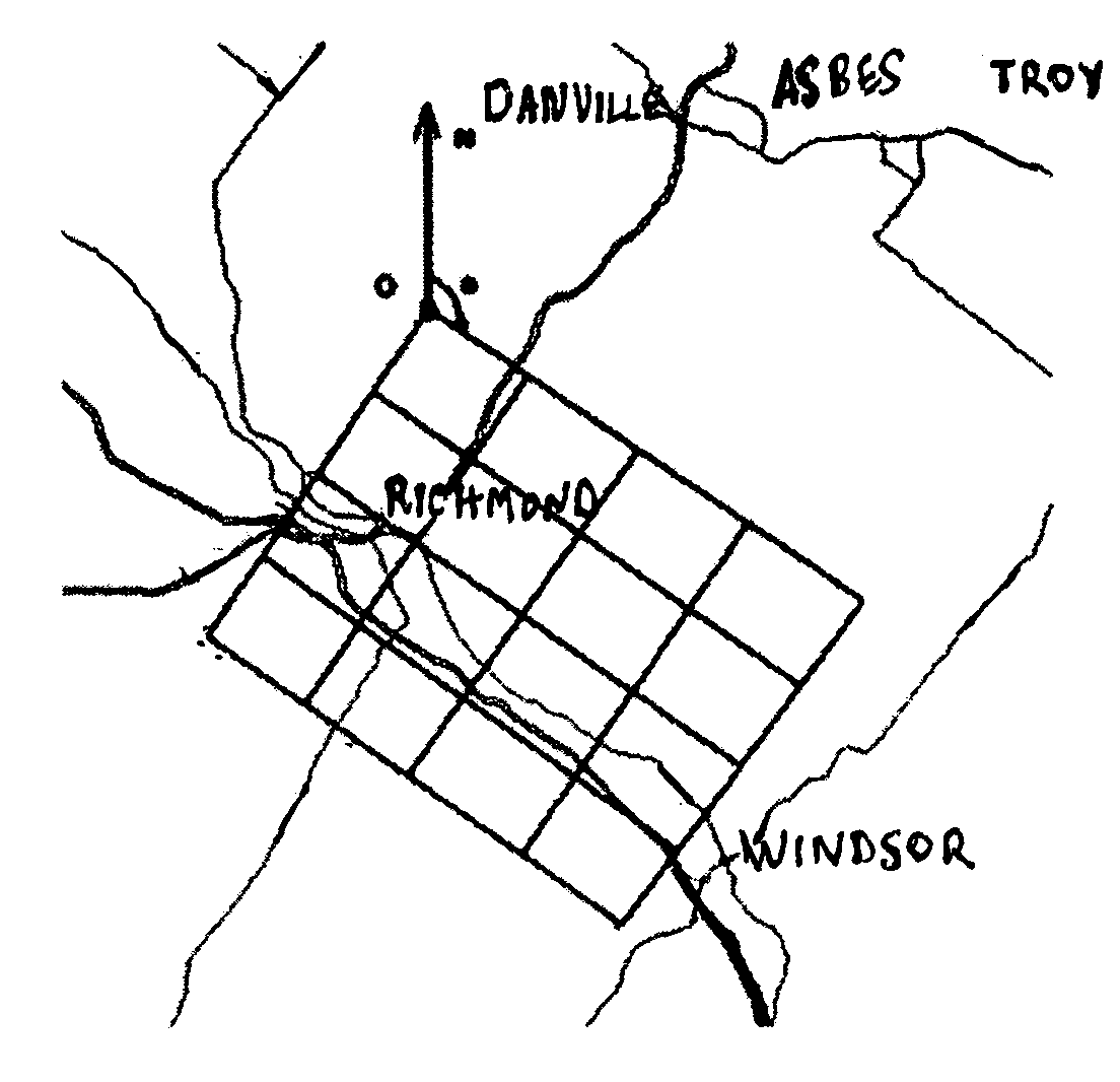
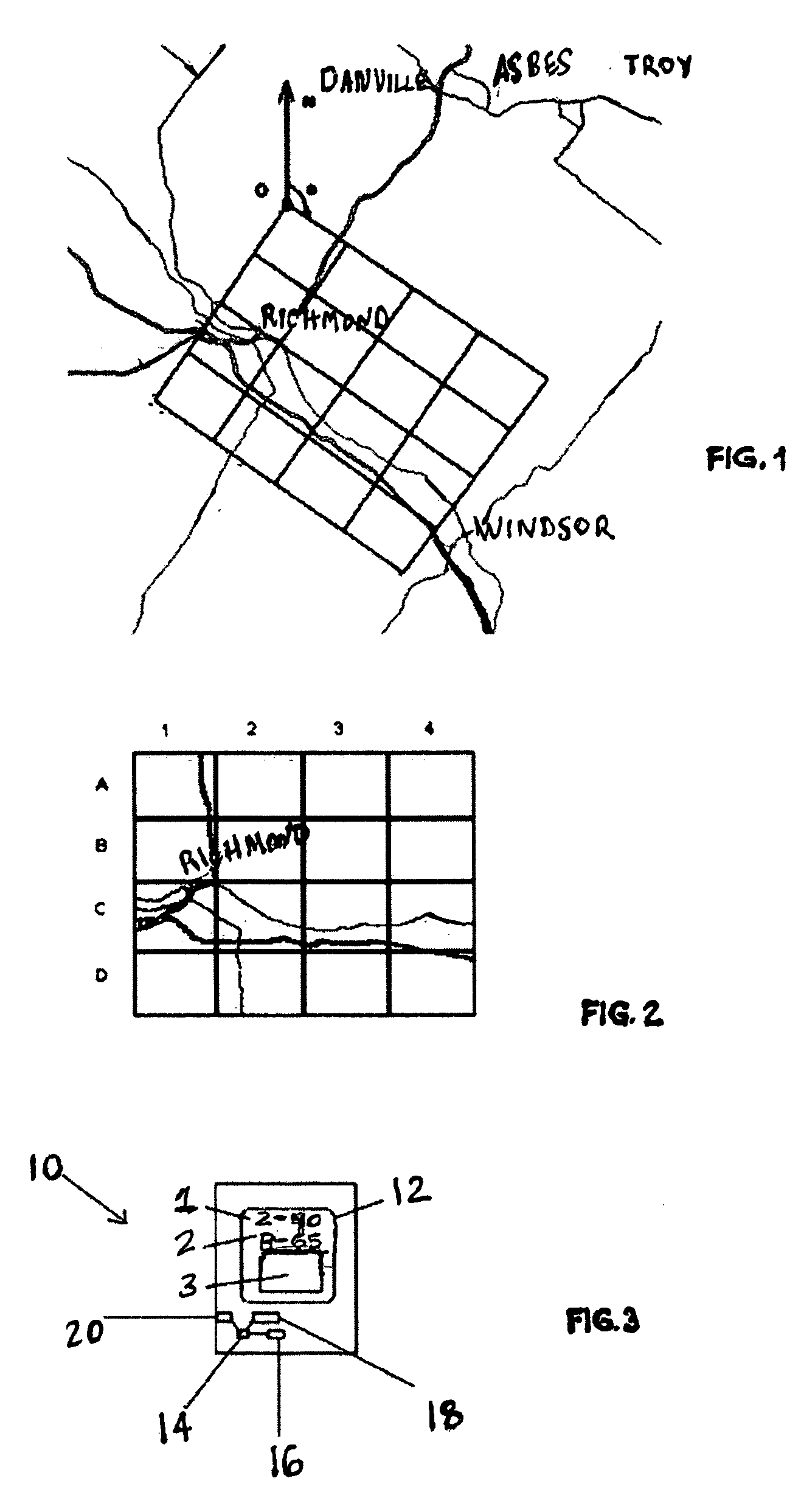
[0021] Referring to the drawings, FIG. 1. and FIG. 2. show a local map grid system. The grid represents a particular defined area over a predetermined geographic area. The user-defined grid setup data can include grid origin, grid size and grid rotation angle. As seen in FIG. 1, the grid is rotated a particular angle “α” from due North N zero degrees (0°) and is shown to cover a region covering Richmond toward Windsor. As seen in FIG. 2, the sixteen blocks of the grid are by way of example labeled 1-4 across the left to right and A-D from the top to bottom. Grids themselves on maps have been used in the past in city maps, local area maps like many downtown maps or community maps. Such prior grids were used in these maps helps user to locate a point of interest by narrowing the searching area. However, the grid systems used in those maps usually are not mapped to earth coordinate and are not readily usable with a satellite based location device like a GPS (Global Positioning System) ...


PUM


Abstract

A method for customizing a local map with a grid that can be rotated and zoomed includes the steps of (a) defining a grid on a map; (b) generating a grid set-up data as a function the defined grid; and (c) employing a computer based device in a manner to receive the grid set-up data and convert a geographical coordinate to a local coordinate on the map. A device for such use includes a computer based device having a processor, a memory operably association with the processor, a power source, means for receiving a geographical coordinate; and geographical coordinate conversion software operably disposed in the memory and operably associated with the processor in a manner to in a manner to receive grid set-up data and convert the received geographical coordinate to a local coordinate on the map.

Description

BACKGROUND OF THE INVENTION [0001] This invention relates to a method and device for customizing a local map with a grid that can be rotated and zoomed for travel planning, travel guidance, and recording travel locations and paths during business or recreational use, particularly in regard to the linkage of small, memory-limited computers. PRIOR ART [0002] Prior devices exist which provide a computer-based travel-planning guide for determining a route between a user selected travel origin and travel destination following user selected intermediate waypoints along the way. Conventional software enables a preferred travel route within user selected constraints. The user can also select among a plurality of types of geographically locatable points of interest (POIs) within a user-defined region of interest along the travel route. A database enables the incorporation of travel information such as graphics, photos, videos, animations, audio and text information about the user selectable ...

Claims


Application Information

Patent Timeline
Patent Type & Authority Applications(United States)
IPC IPC(8): G08G1/123G01C21/32
CPCG01C21/20G09B29/102
Inventor XU, TONYGRAHAM, ROBERT WILLIAM
Owner XU TONY
Why Eureka
Try Eureka