
GPS reference system providing a synthetic offset vector for dithering a rover station position

Active Publication Date: 2006-11-30
TRIMBLE NAVIGATION LTD
View PDF9 Cites 9 Cited by
  • Summary
  • Abstract
  • Description
  • Claims
  • Application Information

AI Technical Summary

Benefits of technology

[0008] In order to meet these requirements, the present invention embodies ways of providing high integrity positioning with controlled accuracies for a rover station either by providing synthetic reference phases for a GPS reference system or by dithering a secure rover position.
[0009] Briefly, the present invention uses or includes one or more real time kinematic (RTK) reference stations for receiving GPS signals at one or more actual reference positions and for measuring reference phases. When three or more reference stations are used, virtual reference phases may be determined for a virtual reference position. A synthetic offset vector is generated in a reference station, a server in the reference system, an RTK rover station, or a synthetic phase processor interacting between the reference stations and the rover station. Reference phase measurements are used with the synthetic offset vector for inferring synthetic reference phases for a synthetic position where the synthetic position is not equal to any of the actual or virtual reference positions. The rover station uses the actual or virtual reference position with the synthetic reference phases in place of the actual or virtual reference phases for computing a rover position with respect to the actual or virtual reference position having an added positional error that is proportional to the synthetic offset vector.
[0010] In another approach a secure RTK rover station uses a synthetic offset vector directly for dithering a secure rover position determined from the actual or virtual reference phase. The synthetic offset vector may be generated in a reference station, a server in the reference system, the rover station, or a processor acting between the reference system and the rover station. The positions determined by the rover station have the integrity of the RTK system with accuracy controlled by the s

Problems solved by technology

However, a user cannot be altogether confident in the accuracies of stand alone or differential GPS positions because the integrity of the positions is affected by multipath.
Multipath reflections of the GPS signals can cause occasional large errors of tens to hundreds of meters or even more depending on the extra distances that are traveled by reflected signals.
Existing GPS RTK systems provide fixed RTK carrier phase measurements to the users for a cost that is largely driven by the fixed infrastructure costs for providing the system divided by the number of users.
Unfortunately, there is no existing technique for spreading the infrastructure costs across more users by providing high integrity positions with accuracies that are lower than the full accuracy of the system.

Method used


Image

  • GPS reference system providing a synthetic offset vector for dithering a rover station position
  • GPS reference system providing a synthetic offset vector for dithering a rover station position
  • GPS reference system providing a synthetic offset vector for dithering a rover station position

Examples


Embodiment Construction

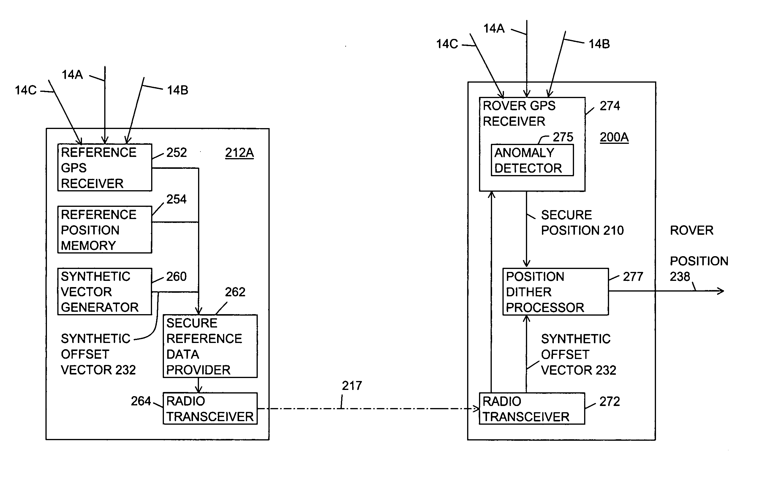
[0037] The details of the preferred embodiments for carrying out the idea of the invention will now be described. It should be understood that the description of these details is not intended to limit the invention to these details. On the contrary these details are merely intended to describe the best mode for carrying out the idea of the invention. Numerous alternatives, modifications and equivalents of the embodiments described herein will be apparent to someone skilled in the art as within the scope of the idea of this invention. The preferred embodiment of the invention is described for the global positioning system (GPS). However, it will be apparent to those in the art that the invention may be carried out with a generic global navigation satellite system (GNSS) including the global positioning system (GPS), the global orbiting navigation system (GLONASS), the Galileo system or a combination of these systems. It should also be noted that pseudolites may be used in place of sa...


PUM


Abstract

A positioning system or synthetic phase processor or rover station for providing high integrity positions with graduated accuracies. The positioning system includes one or more real time kinematic (RTK) reference stations for receiving GPS signals at established reference positions and measuring reference phases. The positioning system or the rover station selects a synthetic offset vector and uses the synthetic offset vector for inferring synthetic reference phases to a synthetic position. The rover station uses the synthetic reference phases with actual or virtual reference positions for determining a rover position having an added positional error controlled by the synthetic offset vector. For another embodiment a secure rover station dithers a secure position with a synthetic offset vector for providing an unsecure rover position having the added positional error.

Description

BACKGROUND OF THE INVENTION [0001] 1. Field of the Invention [0002] The invention relates generally to positioning and more particularly to positioning with high integrity positions having graduated accuracies. [0003] 2. Description of the Background Art [0004] The Global Positioning System (GPS) is operated by the United States government for providing free GPS positioning signals to all users around the world. Stand alone GPS receivers can use a coarse / acquisition (C / A) code in these signals for computing unaided positions having typical accuracies of about five to twenty meters. These accuracies are sufficient for some applications including most navigation applications. However, there are positioning applications, such as survey, mapping, machine control and agriculture, where greater accuracy or integrity is needed. [0005] Some of these needs are met by differential GPS systems that provide GPS code phase corrections. A GPS receiver that is constructed for differential GPS oper...

Claims


Application Information

Patent Timeline
IPC IPC(8): G01S5/14G01S19/04
CPCG01S19/04
Inventor BIRD, DAVID G.
Owner TRIMBLE NAVIGATION LTD
Features
  • Generate Ideas
  • Intellectual Property
  • Life Sciences
  • Materials
  • Tech Scout
  • Unparalleled Data Quality
  • Higher Quality Content
  • 60% Fewer Hallucinations
Learn More