Generalization of Features In A Digital Map

a technology of digital maps and features, applied in the field of generalization of features in digital maps, can solve the problems of large data files, difficult to accurately represent complex shapes like mountain roads, and long processing time, etc., and achieve the effect of simplifying polylines

Active Publication Date: 2007-02-01
UBER TECH INC
View PDF7 Cites 25 Cited by
  • Summary
  • Abstract
  • Description
  • Claims
  • Application Information

AI Technical Summary

Benefits of technology

[0018] The present invention enables generalization of features in a digital map by performing a simplification of polylines. A set of chords between points on the original polyline is selected such that each chord does not violate rules such as maximum distance from the original polyline, maximum distance between points, and the like. If a chord between two points on the polyline is considered acceptable, then a node representing the chord is created, described by the start and end points of the chord. Next, for pairs of nodes created, a transition from the first node in the pair to the second node in the pair is evaluated to determine whether it is acceptable. In one embodiment, a transition is acceptable if the absolute value of the angle formed by the chords is within a threshold angle from the angle formed by the original polyline at that point. If the transition is acceptable, a link between the two nodes is established. After each pair of nodes is considered, a set of paths through a directed graph can be evaluated for cost. The cost of a path includes the sum of costs assigned to each node and link in the path. A least-cost path through the graph is chosen, and a simplified polyline is then generated according to the selected path.

Problems solved by technology

For maps at all but the largest (most zoomed-in) scale, it is physically impossible to represent complex shapes like mountain roads exactly, because the width of the line describing the object is much too great to allow the true shape of the object to be illustrated.
This makes the data file much larger than necessary, and makes the processing time much longer than necessary as well.
However, simplification can be carried out in a variety of ways, and conventional methods have some significant drawbacks associated with them.
However, since those chords are not considered in relation to other nearby chords, this can cause several problems when the resulting simplified polylines are used.
When the polylines are used for a purpose in which angles have significance, such as some driving-time estimating methods, the result can be significantly different from the original polyline, reducing the utility of the simplified polyline.
A more serious problem is that because the relationship of two chords that meet at a kept point is not constrained, the angle formed at the point can be reversed.
If the polyline is used to describe a driving route, this can be unfortunate, causing a driver to go in the wrong direction.
If it is used as the boundary of an area, such as a park or lake, the result is even worse—such a change in angle can make the boundary of the area no longer topologically correct, turning the area inside-out, and making it impossible to draw the area correctly using the new polyline.

Method used


Image

  • Generalization of Features In A Digital Map
  • Generalization of Features In A Digital Map
  • Generalization of Features In A Digital Map

Examples


Embodiment Construction

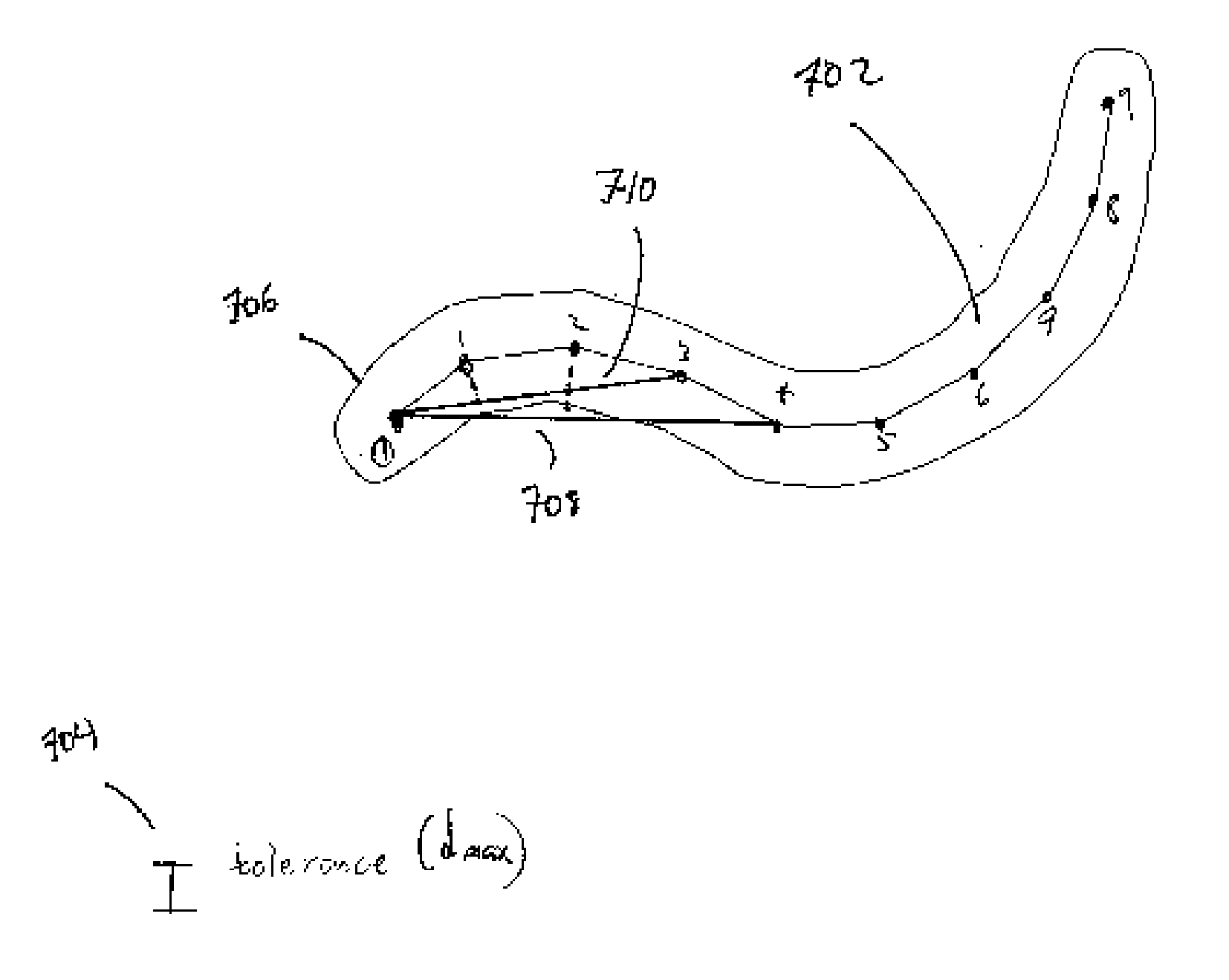
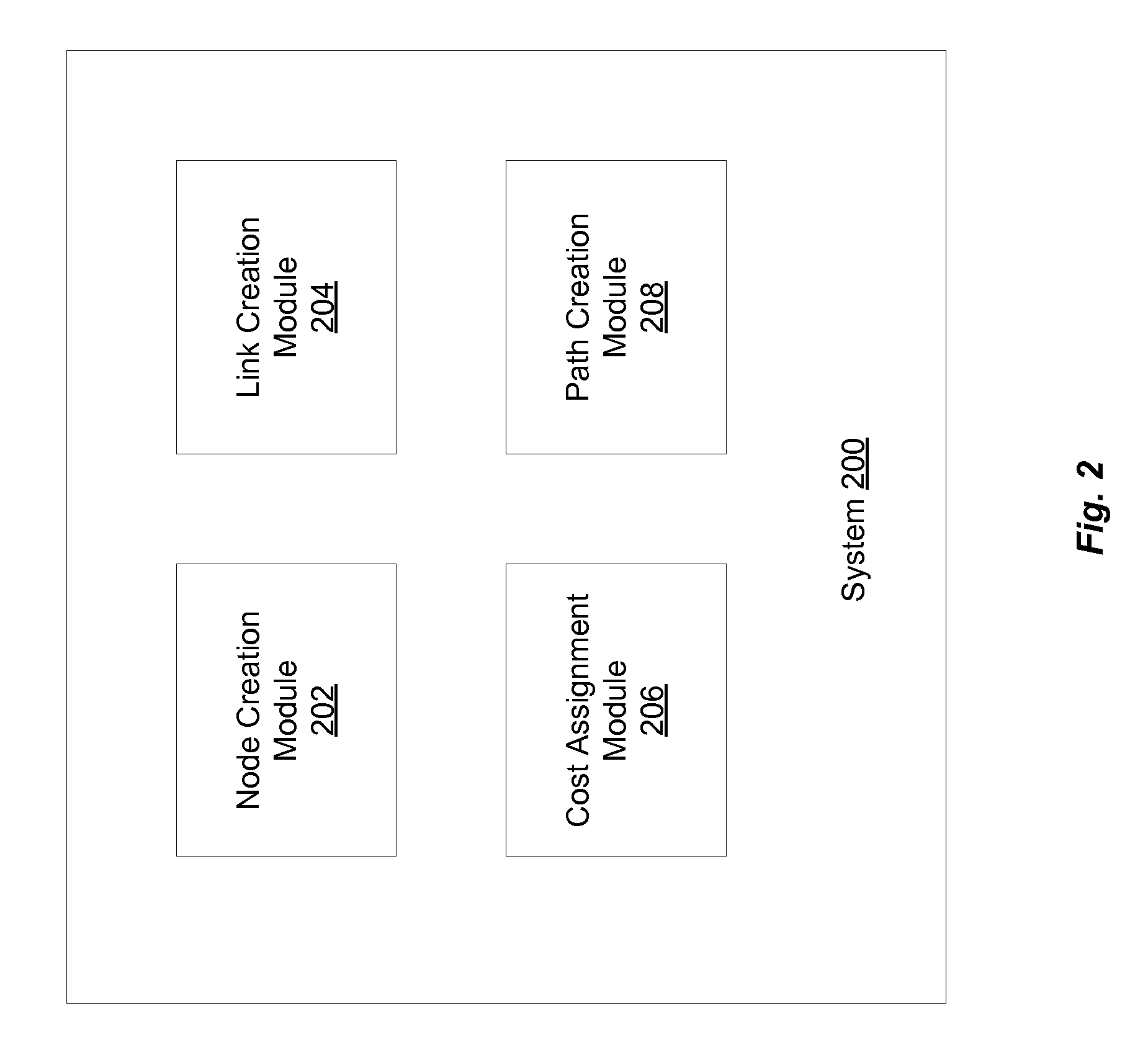
[0027]FIG. 2 illustrates a block diagram of a system 200 for generalizing features in a digital map in accordance with an embodiment of the present invention. System 200 includes a node creation module 202, for creating a set of nodes; a link creation module 204 for creating a set of links; a cost assignment module 206 for assigning costs to the links and nodes created by link creation module 204 and node creation module 202, respectively; and a path creation module 208 for creating a least-cost path through a graph created as described now with respect to FIG. 3.

[0028] As noted above, in order to create a map with generalized features in accordance with the present invention, a graph is created. FIG. 3 illustrates the construction of such a graph in a preferred embodiment. A graph is constructed by first creating 302 a set of nodes, as described further below with respect to FIG. 4. Next, links are created 304 between the nodes, as described further below with respect to FIG. 5. F...


PUM


Abstract

Generalization of features in a digital map is enabled by performing a simplification of polylines. A set of chords between points on a polyline is selected such that each chord does not violate specified rules such as maximum distance from the original polyline. If a chord is acceptable, a node representing the chord is created, described by the start and end points of the chord. For pairs of nodes created, a transition from the first node to the second node is evaluated to determine whether it is acceptable. In one embodiment, a transition is acceptable if the absolute value of the angle formed by the chords is within a threshold angle from the angle formed by the original polyline at that point. If the transition is acceptable, a link between the two nodes is established. A least-cost path through the graph is chosen, and a simplified polyline is then generated.

Description

CROSS-REFERENCE TO RELATED APPLICATIONS [0001] This application claims the benefit of U.S. Provisional Application 60 / 702,778, filed on Jul. 26, 2005, incorporated by reference herein in its entirety.BACKGROUND OF THE INVENTION [0002] 1. Field of the Invention [0003] The present invention is related to generalization in digital maps. [0004] 2. Description of the Related Art [0005] Generalization in Maps [0006] When a paper map is produced, shapes of objects represented in the map are rarely the same as they are in reality. For maps at all but the largest (most zoomed-in) scale, it is physically impossible to represent complex shapes like mountain roads exactly, because the width of the line describing the object is much too great to allow the true shape of the object to be illustrated. Cities, parks, and other areas may also have boundaries with complex shapes. Even when the line on a map is not too wide to allow a true representation of a shape, cartographers often smooth out a com...

Claims


Application Information

Patent Timeline
Patent Type & Authority Applications(United States)
IPC IPC(8): G06T11/20G06T17/05
CPCG06T9/20G06T17/05G06T11/203
Inventor POPPEN, RICHARD F.
Owner UBER TECH INC
Why Eureka
Try Eureka