Navigation signal differential acquisition method and systems therefor

a technology of navigation signal and acquisition method, applied in the field of communication methods used in satellite navigation system, can solve the problems of signal detection and synchronization, high amount of computation required, and time-domain and frequency-domain convolution suffer from computational scaling issues

Active Publication Date: 2008-05-29
2201028 ONTARIO
View PDF4 Cites 18 Cited by
  • Summary
  • Abstract
  • Description
  • Claims
  • Application Information

AI Technical Summary

Benefits of technology

[0012]Preferably, the step of nonlinear processing further includes discarding an imaginary component of the digitized samples of the first signal for short delay periods or small residual carrier frequencies. Also, the method may include rotating, on a complex plane, at least one of the second signal and the third signal so that the at least one signal falls on or near a real or an imaginary axis of the complex plane. The method may also include determining a chip timing drift rate for each of the received navigation signals and inserting or deleting samples in the digitizing samples step to compensate for the chip timing drift rate. Also, the inserting or deleting step may include passing multiple coherently averaged sections of the first signal though delay and advance filters.

Problems solved by technology

One of the key problems in the use of satellite navigation systems such as GPS is detection of and synchronization to the signals from the satellites (often termed “acquisition”).
Although the frequency-domain approach is attractive, the amount of computation required can be very high, especially in unassisted receivers which have no side information (for example from a cellular radio link) on the receiver frequency error.
Both time-domain and frequency-domain convolution suffer from a computational scaling issue with coherent integration.
One of the limitations to coherent integration is loss due to bit transitions in the navigation data.

Method used


Image

  • Navigation signal differential acquisition method and systems therefor
  • Navigation signal differential acquisition method and systems therefor
  • Navigation signal differential acquisition method and systems therefor

Examples


Embodiment Construction

[0023]A preferred embodiment of the present invention will be set forth in detail with reference to the drawings, in which like reference numerals refer to like elements or operational steps throughout.

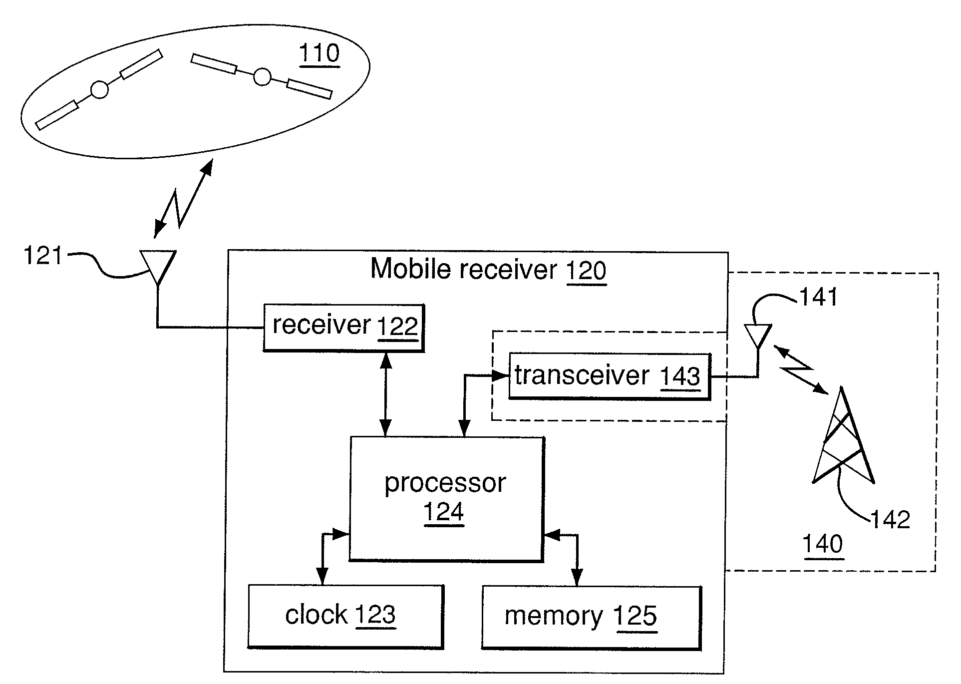
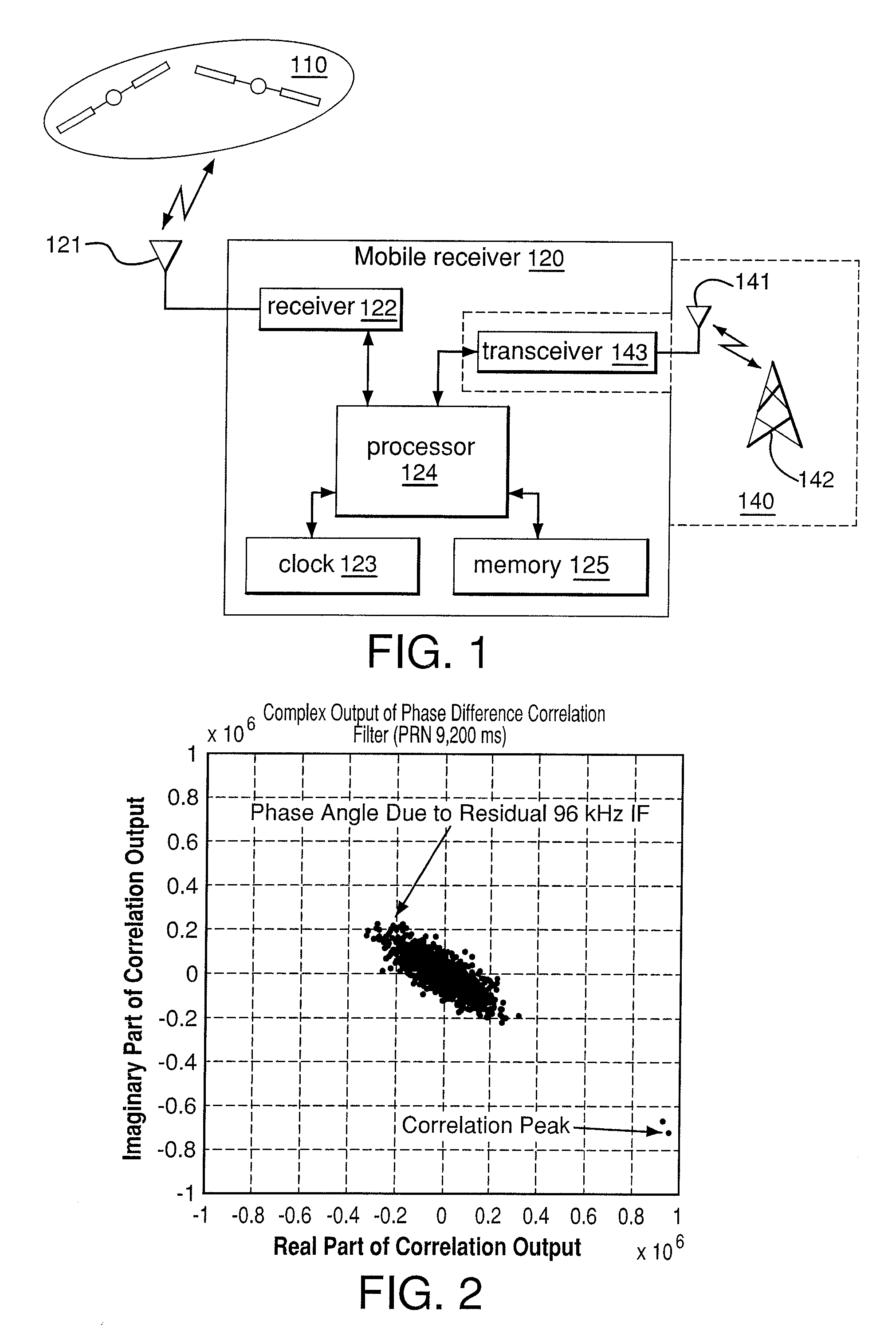
[0024]The communication methods used in satellite navigation systems and a receiver for processing those signals, according to at least one embodiment, are illustrated in FIG. 1. A mobile receiver 120 communicates with multiple satellites 110 through an antenna or antennas 121. The received signals are processed through the receiver module 122 and forwarded to the processor 124. The processor 124 has access to memory 125 and has a reference clock 123 that is used in the processing of the signals. Additionally, the processor 124 of the mobile receiver 120 may also have access to a transceiver 143, that is used to send and receive other signals, through an antenna 141 to other sources 142, in the terrestrial arena 140. The other sources can, in some embodiments, be used to determine and...


PUM


Abstract

A method of acquiring signals from satellites in a Global Positioning System (GPS) is disclosed. The method includes receiving navigation signals from the satellites of the GPS, down-converting to complex baseband the received navigation signals to form a first signal, digitizing samples of the first signal, nonlinear processing of the digitized samples of the first signal to form a second signal, where the nonlinear processing comprises forming a weighted sum of products of pairs of the digitized samples at different relative delays, in which one of each of the pairs has been complex conjugated, coherent averaging the second signal over integer multiples or submultiples of a spreading sequence period of the navigation signals to form a third signal, performing circular correlation processing of the third signal with a representation of each navigation signal of the navigation signals and determining a timing offset at which a correlated output energy is maximized, based on the circular correlation processing.

Description

CROSS-REFERENCE TO RELATED APPLICATIONS[0001]This application claims benefit of U.S. Provisional Patent Application No. 60 / 861,450, filed on Nov. 29, 2006. The full disclosure of this provisional application is incorporated herein by reference.FIELD OF THE INVENTION[0002]The present invention relates to communication methods used in satellite navigation systems. More specifically, the present invention is directed to improved methods of acquisition of spread spectrum satellite navigation signals that reduce the required computational complexity when compared to other methods.DESCRIPTION OF RELATED ART[0003]One of the key problems in the use of satellite navigation systems such as GPS is detection of and synchronization to the signals from the satellites (often termed “acquisition”). As a minimum, receivers must measure the carrier frequency or spreading code phase (delay), or both; typically unassisted receivers must additionally determine and track the signal carrier phase to enabl...

Claims


Application Information

Patent Timeline
Patent Type & Authority Applications(United States)
IPC IPC(8): G01S1/00G01S19/29
CPCG01S19/21G01S19/37G01S19/30G01S19/29
Inventor HOUTMAN, TOM
Owner 2201028 ONTARIO
Why Eureka
Try Eureka