Automated location-based information recall

Active Publication Date: 2008-07-03
PIONEER HI BRED INT INC
View PDF71 Cites 94 Cited by
  • Summary
  • Abstract
  • Description
  • Claims
  • Application Information

AI Technical Summary

Problems solved by technology

One problem with data collection and analysis associated with crop production and other land management activities is in identifying fields and field boundaries.
This problem presents itself in various ways.
Another problem with data collection and analysis is the ability to collect data from a producer or other user and provide analysis of the collected information or other useful information to the producer or other user at the point and time of need.
This problem also presents itself in various ways.
Another problem relates to creating electronic records for production information which are convenient for the producer or other user and provide a benefit to the producer or other user beyond the benefits of paper records.

Method used


Image

  • Automated location-based information recall
  • Automated location-based information recall
  • Automated location-based information recall

Examples


Embodiment Construction

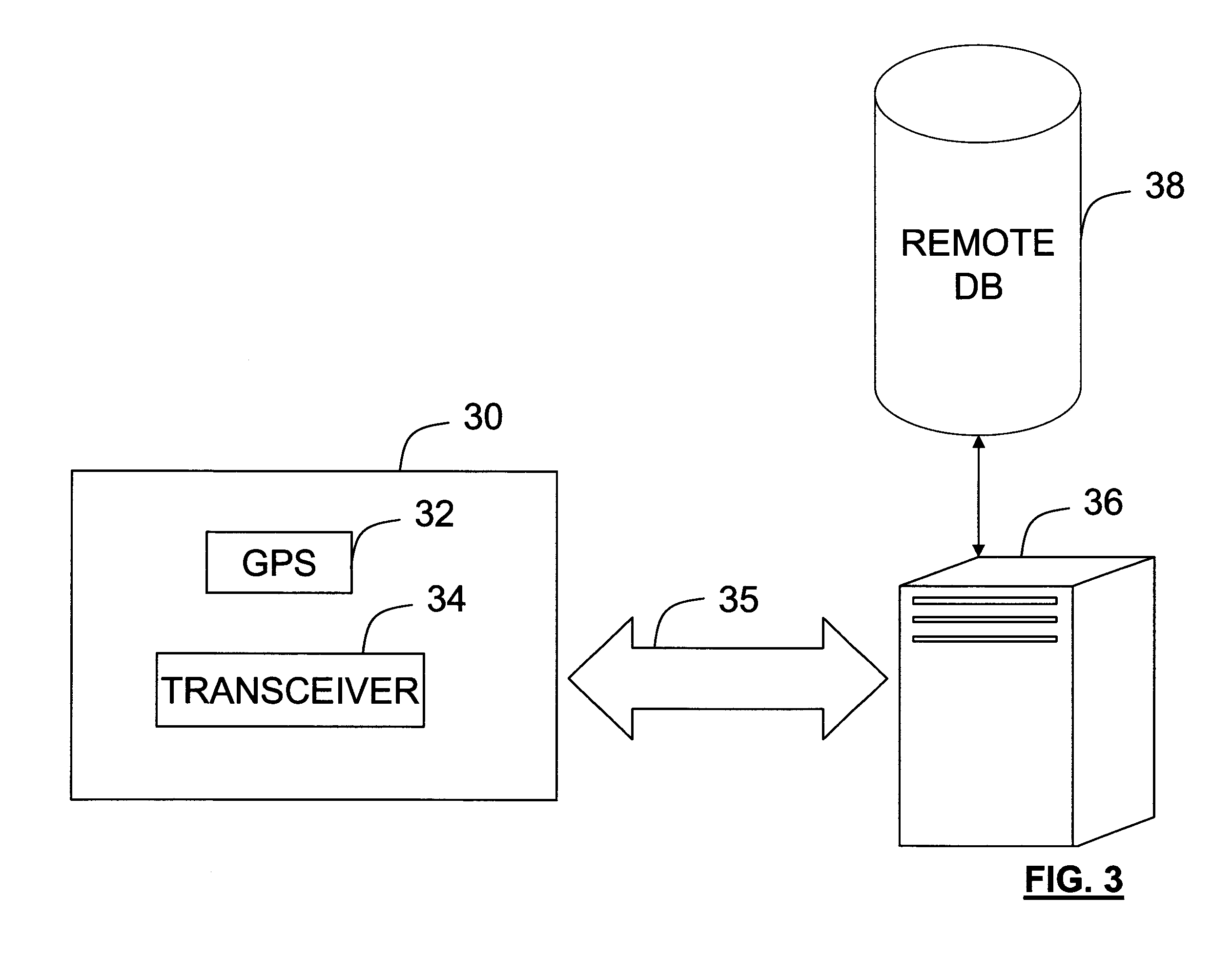
[0023]A GPS enabled device with wireless communications capability such as a cell phone, properly equipped personal digital assistant (pda), or properly equipped computer is used for collecting data within a land management zone such as a field or other crop management zone and communicating the data to a remote location. The data can then be stored at the remote location. A remote location is one that may be positioned outside of the land management zone and may be nearby or around the world. Alternatively, the data can be analyzed at the remote location and the results of the analysis can then be communicated back to the GPS enabled device at the field or other crop management zone or land management zone.

[0024]Such a system has numerous potential advantages. Because a GPS enabled device is used, geolocation information is collected which can be associated with the user's observations. The geolocation information can further be used to identify a land management zone or crop manag...


PUM


Abstract

A geoposition is determined at a point using a geoposition determining mobile communication device. A crop management zone is identified based on one or more predetermined crop management boundaries and the geoposition of the point. Information about the field is wirelessly communicated between the geoposition determining mobile communications device and a remote site. Analysis may be performed at the remote site with the results of the analysis communicated to the mobile communication device at the growing point. Information may be collected at the point which is stored or analyzed at the remote site. Information may include digital images of plant conditions which may be analyzed to determine conditions such as disease or pest infestation. Contextual information from a number of different types of sources may be used to provide meaningful analysis and feedback to the producer. The producer may define crop management zones using the geoposition determining mobile communication device.

Description

CROSS-REFERENCE TO RELATED APPLICATIONS[0001]This application claims priority to U.S. Provisional Application Ser. No. 60 / 882,756 filed Dec. 29, 2006, herein incorporated by reference in its entirety.FIELD OF THE INVENTION[0002]The present invention includes various methods and systems relating to data collection, record keeping and analysis used in land management activities such as, but not limited to crop production, particularly where the data collection, record keeping, and results of the analysis are available within the field or other land management zone.BACKGROUND OF THE INVENTION[0003]One problem with data collection and analysis associated with crop production and other land management activities is in identifying fields and field boundaries. This problem presents itself in various ways.[0004]Another problem with data collection and analysis is the ability to collect data from a producer or other user and provide analysis of the collected information or other useful infor...

Claims


Application Information

Patent Timeline
Patent Type & Authority Applications(United States)
IPC IPC(8): G08B21/00
CPCG06Q10/06G06Q50/02G06Q10/00G06Q10/087
Inventor BELZER, WILLIAM A.PETERSON, TODD A.GARDNER, DOUGLAS L.RICHARDSON, WARRENANDERSON, BARRYTERNDRUP, DANA TORQUILHERSHEY, TRACYCORAK, STEVEN J.LANGER, DAVID K.BOWEN, DAVID
Owner PIONEER HI BRED INT INC
Why Eureka
Try Eureka