System and method for providing multiple participants with a central access portal to geographic point of interest data

a technology of geographic point of interest and central access, applied in the field of electronic maps, electronic documents, electronic databases, etc., can solve the problems of large time lapse of several days, no single company has been able to meet the growing demand for precise positional accuracy and regularly updated, and no common terminology among divergent conten

Inactive Publication Date: 2008-07-03
TELE ATLAS NORTH AMERICA
View PDF9 Cites 124 Cited by
  • Summary
  • Abstract
  • Description
  • Claims
  • Application Information

AI Technical Summary

Benefits of technology

[0016]Described herein is a system and method of providing multiple participants with a centrally accessible content portal for geographic point of interest (POI) data, for subsequent use in creating map-based or spatial applications. In accordance with an embodiment, the system allows different entities to dynamically upload, update, retrieve, and use digital map and POI data. Advantages of the present invention include the ability to handle the large amounts of POI data needed by multiple Application Developers, even though much of that data is dynamic, or frequently changing; the ability to update POI attribute information and deliver it to the Application Developer; the ability to associate multiple points of entry (POE) with a POI, and to aggregate data from multiple Content Providers; and the use of a common geocoding engine and common digital map reference across all Content Providers, which ensures the consistency of the geocoding throughout all the POI data.

Problems solved by technology

To date, no single company has been able to meet the growing demand for precise positional accuracy and regularly updated information about the newest business, recreational, and critical services.
Some of the problems that are particularly relevant to delivering POI content include:
However, once the sources are found and acquired, there is no common terminology among the divergent content.
However, using traditional methods there is often a large time lapse of several days between the initial collection and the final delivery of the geocoded content.
As such, there is no way to determine the consistency of the geocoding results from one set of content to another, or how the geocoding will mesh with the particular mapping engine that a software Application Developer will later use.
Nor do Application Developers have any way to manage their content subscriptions across multiple content data sets and Content Providers.

Method used


Image

  • System and method for providing multiple participants with a central access portal to geographic point of interest data
  • System and method for providing multiple participants with a central access portal to geographic point of interest data
  • System and method for providing multiple participants with a central access portal to geographic point of interest data

Examples


Embodiment Construction

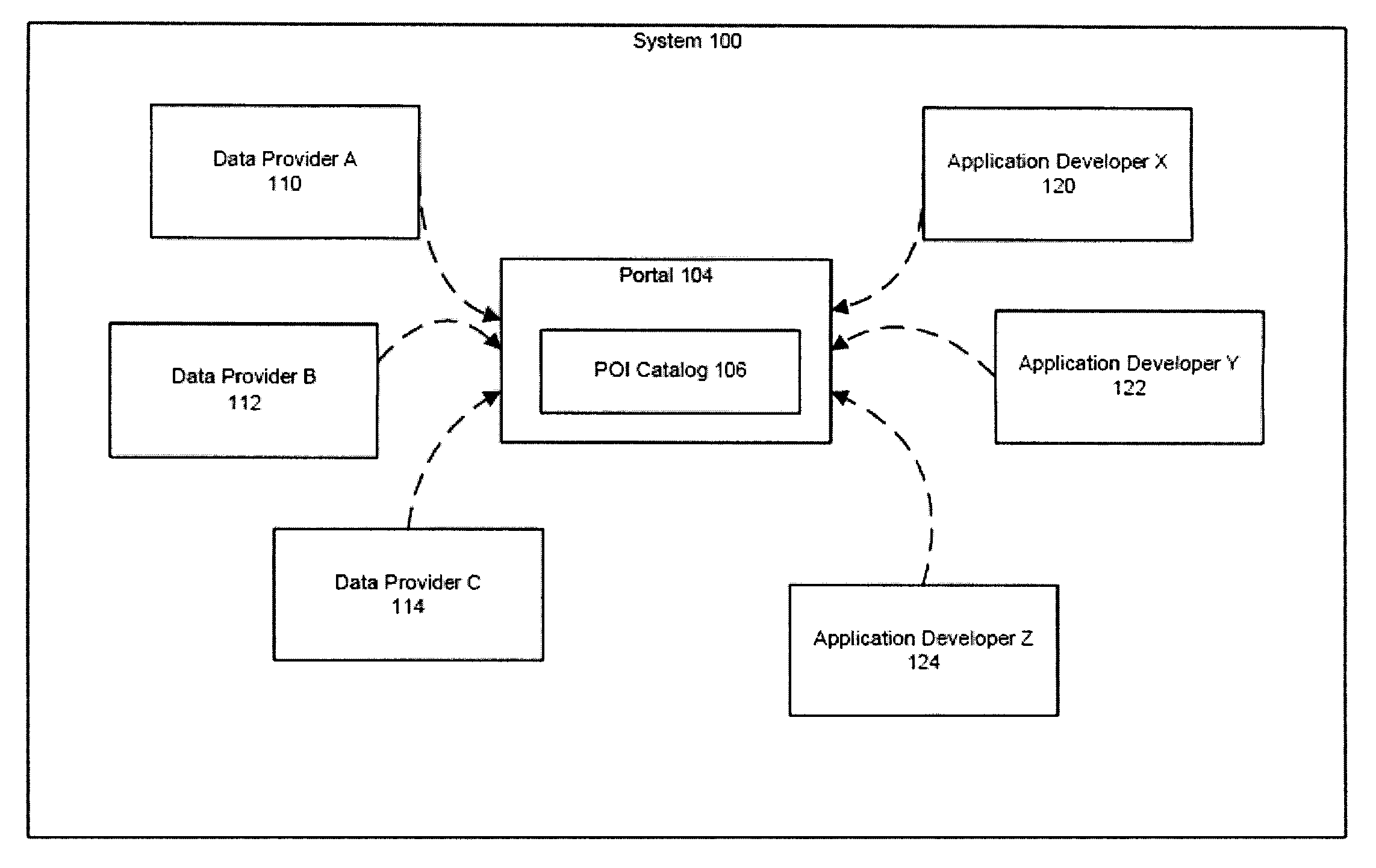
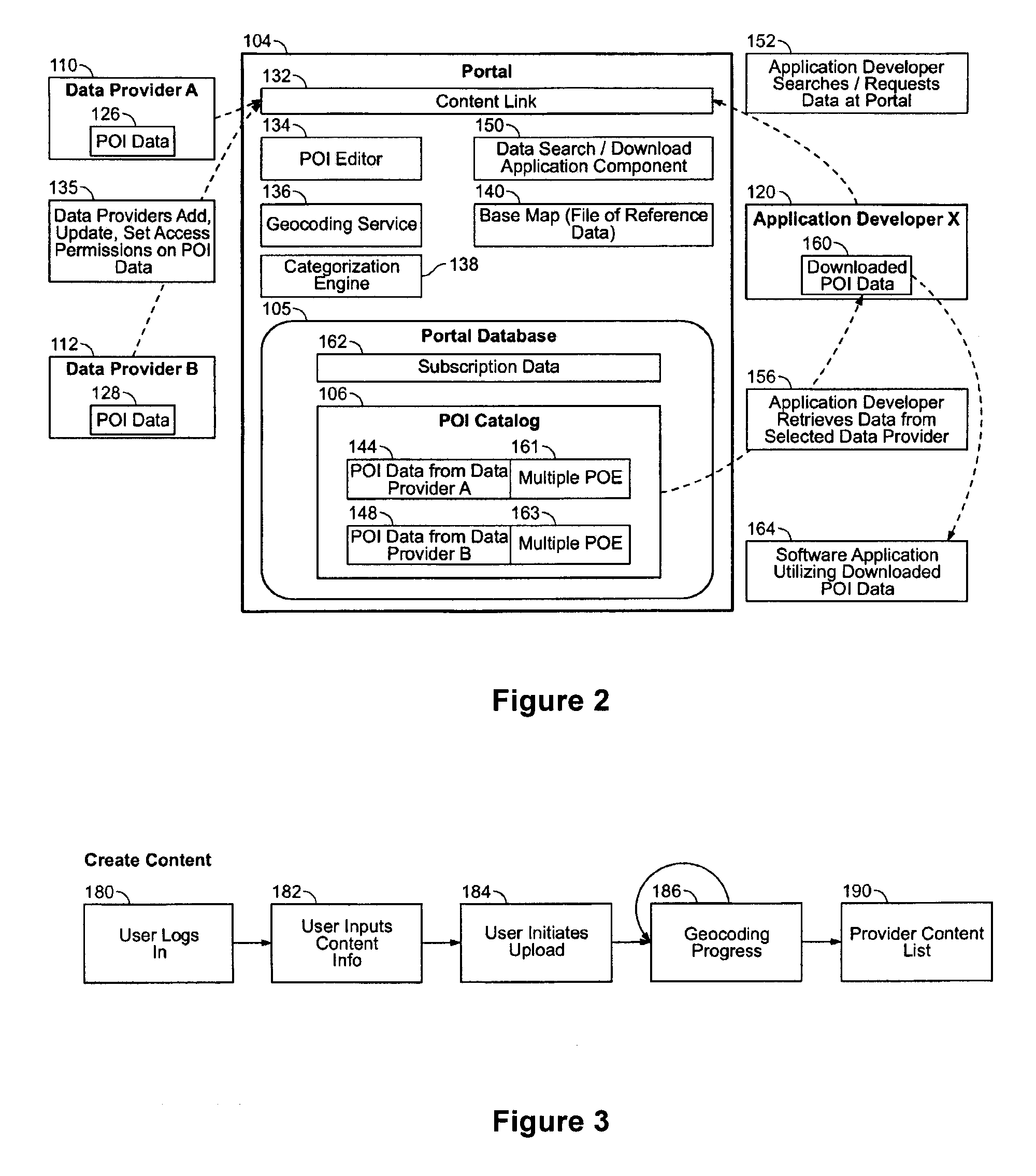
[0105]As described above, digital maps have become commonplace in modern society, and include an ever greater variety of data content and points of interest (POIs). The variety of different uses for these maps has also expanded. However, to date, no single company has been able to meet the growing demand for precise positional accuracy and regularly updated information about the newest business, recreational, and critical services; and other POI information. In accordance with an embodiment of the present invention, a system and a method is described which provides multiple participants with a centrally accessible content portal of geographic point of interest (POI) data, for subsequent use in creating map-based applications. Advantages of the present invention include:

[0106]The system can handle large amounts of POI data. Any portion of the POI information in a particular entry can be easily updated and delivered to the Application Developer, either by subscription means, or by the...


PUM


Abstract

A system and method of providing multiple participants with a centrally accessible content portal for geographic point of interest (POI) data, for subsequent use in creating map-based or spatial applications. Different entities can dynamically upload, update, retrieve, and use digital map and POI data. Additional features include the ability to handle the large amounts of POI data needed by multiple Application Developers, including data that is dynamic, or frequently changing; the ability to update POI attribute information and deliver it to the Application Developers; the ability to associate multiple points of entry (POE) with a POI, and to aggregate data from multiple Content Providers; and the use of a common geocoding engine and common digital map reference across all Content Providers, which ensures the consistency of the geocoding throughout all the POI data.

Description

CLAIM OF PRIORITY [0001]This application claims the benefit of U.S. Provisional Patent Application titled “SYSTEM AND METHOD FOR PROVIDING MULTIPLE PARTICIPANTS WITH A CENTRAL ACCESS PORTAL TO GEOGRAPHIC POINT OF INTEREST DATA”; Inventors: Mary R. Becker, Roger Brown, Jennifer Parker LaFlamme, Craig Sabbey, Jay Undercoffler, Richard Cohen, and Rik Temmink; Application No. 60 / 858,613; Filed Nov. 13, 2006; and also claims the benefit of U.S. Provisional Patent Application titled “SYSTEM AND METHOD FOR PROVIDING MULTIPLE PARTICIPANTS WITH A CENTRAL ACCESS PORTAL TO GEOGRAPHIC POINT OF INTEREST DATA”; Inventors: Mary R. Becker, Craig Patrick Sabbey, Jay W. Undercoffler, Richard Cohen, Rik Temmink, David Goldberg, Roger W. Brown and Jennifer Parker; Application No. 60 / 949,757; Filed Jul. 13, 2007; each of which applications are herein incorporated by reference.COPYRIGHT NOTICE[0002]A portion of the disclosure of this patent document contains material which is subject to copyright protect...

Claims


Application Information

Patent Timeline
Patent Type & Authority Applications(United States)
IPC IPC(8): G06F3/048G06F15/16
CPCG06Q30/00
Inventor BECKER, MARY R.SABBEY, CRAIG PATRICKUNDERCOFFLER, JAY W.COHEN, RICHARDTEMMINK, RIKGOLDBERG, DAVIDJONES, MICHELLEBROWN, ROGER W.PARKER, JENNIFER
Owner TELE ATLAS NORTH AMERICA
Why Eureka
Try Eureka